What it is
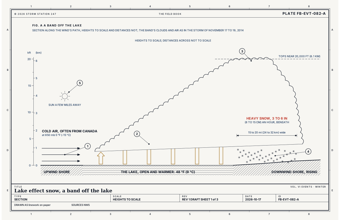
Lake effect snow is snow made by a lake. When cold air, often from Canada, crosses the open water of one of the Great Lakes in late fall and winter, the water, still far warmer than the air, warms and moistens the air from below. The air rises, and clouds form and grow into narrow bands that can drop 2 to 3 in (5 to 8 cm) of snow an hour or more on the shore downwind. Heavy snow can be falling in one place while the sun shines a mile or two away.
The Weather Service warns it, where a region chooses, with a Lake Effect Snow Warning: lake-induced snow squalls or heavy snow showers that bring snow meeting the office's warning criteria, usually in narrow bands over a limited area. Other regions warn it as a Winter Storm Warning, and a Winter Storm Watch or a Winter Weather Advisory can carry lake effect snow alone. The criteria are the office's own: 7 in (18 cm) of snow in one event across the Buffalo office's zones, 6 in (15 cm) across the Cleveland office's.
What it is not
It is not a snow squall, Snow squall FB-EVT-086: a brief burst of heavy snow and wind, often along a cold front, that passes in minutes. A lake effect band can hold over the same ground for days.
It is not a winter storm, Winter storm FB-EVT-080: snow from a large storm system, over a wide region. Lake effect snow comes from the lake itself, and the sky can be clear a few miles from the band.
It is not a blizzard, Blizzard FB-EVT-081, which is warned for the wind and the visibility, not for how much snow falls, though a strong band can bring both.
Lookalikes
- Snow squall
- A brief burst of heavy snow and wind, often along a cold front, that passes in minutes, Snow squall FB-EVT-086. A lake effect band can hold over the same ground for days.
- Winter storm
- Snow from a large storm system over a wide region, Winter storm FB-EVT-080. Lake effect snow comes from the lake itself, in narrow bands, often under fair weather elsewhere.
- Blizzard
- Wind and snow that hide the way, Blizzard FB-EVT-081, warned for the wind and the visibility, not the amount.
Machine
Warm water under cold air
A large lake gives up its summer heat slowly, and through late fall and early winter its open water stays much warmer than the arctic air that crosses it. The water heats the lowest air and adds moisture to it, and the warmed air rises. Air rising without reaching saturation cools as it expands, by 5.4 °F for every 1,000 ft (9.8 °C per km), the dry adiabatic lapse rate of Lapse rates and stability FB-ENG-005. Where the air above the lake is colder than that, the warmed air stays warmer than its surroundings and keeps rising: the deeper the cold above warm water, the taller the clouds grow. The equation below works it for the storm Figs. B and C draw.
The wind sets the band
The longer the air's path over open water, the more heat and moisture it gathers, so the heaviest bands come when the wind blows along the length of a lake. The wind's direction decides where the band comes ashore, and a steady wind holds it there, hour after hour, over the same towns. A shift of the wind sends the band north or south, onto other towns, or out over the water. The lie of the land downwind matters too: rising ground lifts the air further and wrings more snow from it.
Narrow and sharp
A band is narrow: the Buffalo office measured the band of November 17 to 19, 2014, at 15 to 20 mi (24 to 32 km) wide. Its edges are sharp. On Transit Road east of Buffalo there were only a few inches on the ground at Genesee Street, and several feet at Walden Avenue, less than 2 miles to the south. Along the band's northern edge, which many described as a wall of snow, the snow fell at more than 3 in (8 cm) an hour, some near 6 in (15 cm), with blue sky to the north.
The storm of November 17 to 19, 2014
The band formed over the Buffalo Southtowns around 6 in the evening on Monday, November 17, settled south of the city and the airport by 9, and locked in place on a line from Lackawanna and Hamburg east-northeast across West Seneca, Lancaster and Alden. By sunrise some places had more than 3 ft (0.9 m), in under 12 hours; by the end of Tuesday, 4 to 5 ft (1.2 to 1.5 m). The band weakened and drifted north on Wednesday morning. South Cheektowaga measured 65 in (165 cm); the Buffalo airport, a few miles north of the band, 6.2 in (16 cm). Fig. B draws the totals to scale; Fig. C the storm hour by hour.
The air was unusually cold for November. The lake was around 48 °F (9 °C), the air at 850 mb 5 °F (−15 °C), and at 500 mb −44 °F (−42 °C), and the clouds grew to near 20,000 ft (6.1 km), as Fig. A draws. There were 13 deaths, hundreds of roofs fell, and thousands of motorists were stranded. A second band, on November 19 and 20, added 1 to 4 ft (0.3 to 1.2 m) more over nearly the same ground.
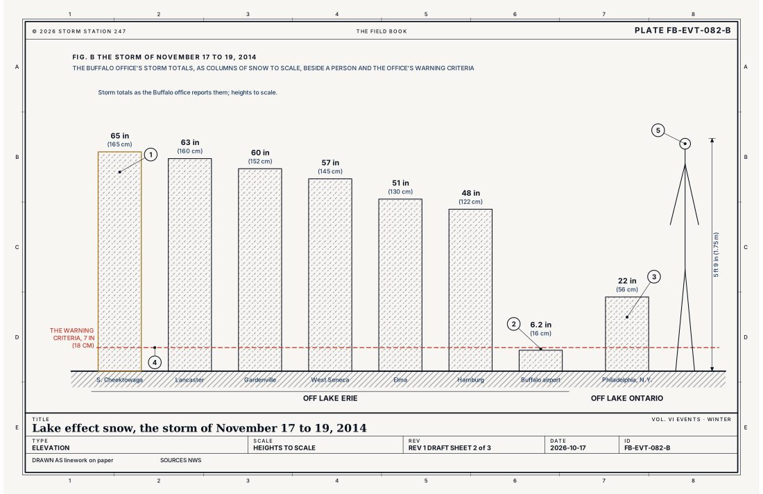
- South Cheektowaga, 65 in (165 cm), the most
- The Buffalo airport, 6.2 in (16 cm), a few miles north
- Philadelphia, New York, off Lake Ontario, 22 in (56 cm)
- The warning criteria, 7 in (18 cm)
- A person, 5 ft 9 in (1.75 m)
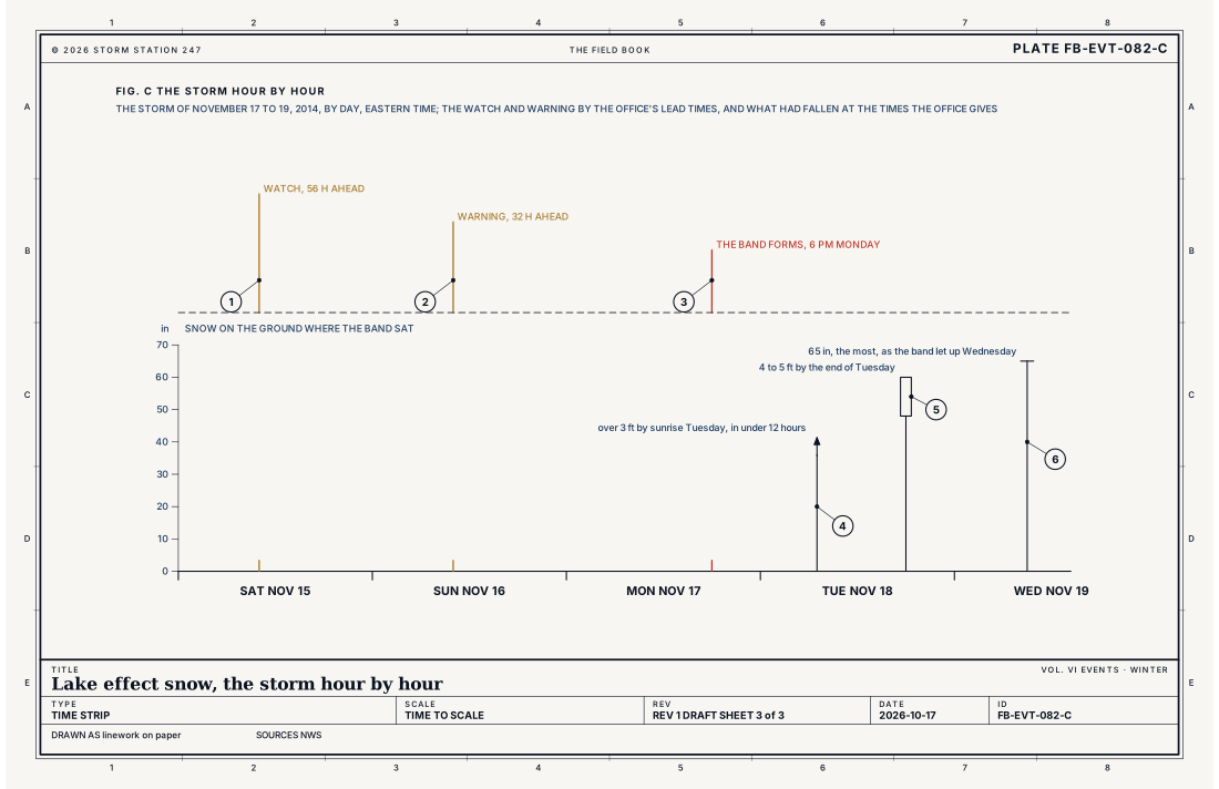
- The watch, 56 hours ahead
- The warning, 32 hours ahead
- The band forms, 6 pm Monday
- Over 3 ft (0.9 m) by sunrise Tuesday
- 4 to 5 ft (1.2 to 1.5 m) by the end of Tuesday
- 65 in (165 cm), the most, as the band let up
Ingredients
- Cold air, often from Canada, crossing a large lake that is still open and much warmer than the air
- A long reach of water under the wind, so the air gathers more heat and moisture
- A steady wind direction, which holds a band over the same ground
- The lie of the land downwind, which can lift the air further
Scales
- time
- hours to days; a band can hold over the same ground for a day or more while the wind holds steady
- horizontal
- bands from a few miles to about 20 miles wide, running tens of miles inland from the shore
- vertical
- clouds from a few thousand feet deep to near 20,000 ft in the strongest storms
- orlanski
- meso-beta to meso-gamma
Equations
How fast rising air cools
- the dry adiabatic lapse rate, 5.4 °F per 1,000 ft (9.8 °C per km)
- the acceleration of gravity, 32.17 ft s⁻² (9.81 m s⁻²)
- the heat needed to warm a kilogram of dry air one degree at constant pressure, 1,004 J kg⁻¹ K⁻¹
Assumes Air rising without reaching saturation cools at this rate by its own expansion. Where the air above a lake is colder than air warmed at the surface would be after rising to the same height, the warmed air stays warmer than its surroundings and keeps rising, and the clouds of a band grow.
Working form Air warmed by a lake at 48.2 °F (9 °C) and rising unsaturated cools 26.8 °F (14.9 °C) in 5,000 ft (1.52 km), to 21.4 °F (−5.9 °C). On November 18, 2014, the air at 850 mb, near a mile above Lake Erie, was 5 °F (−15 °C): the rising air stayed 16.4 °F (9.1 °C) warmer than the air around it and kept rising, and the clouds reached near 20,000 ft (6.1 km).
Signatures
- surface
- the wind steady from across the lake; snow heavy in one town and the sky clear a few miles away
- satellite
- cloud streets or a single long band of cloud running off the lake; clear sky upwind
- radar
- a long; narrow band of echo running from the lake onto the shore; often holding in place for hours
- sounding
- very cold air above a warm lake; the air near the lake unstable up to a few thousand feet or; in the strongest; near 20; 000 ft
Numbers
| Quantity | Value, and the kind of number it is |
|---|---|
| Lake Effect Snow Warning | Lake-induced snow squalls or heavy snow showers, widespread or localized, producing snow that meets or exceeds locally defined warning criteria; issued at each region's discretionStandard, Directive 10-513 |
| Where it falls | Usually in narrow bands, over a limited areaStandard, Directive 10-513 |
| In other products | A region may warn it as a Winter Storm Warning; a Winter Storm Watch or Winter Weather Advisory may carry lake effect snow aloneStandard, Directive 10-513 |
| How long an event runs | Set by the office, and not over 48 hours unless absolutely necessaryStandard, Directive 10-513 |
| The Buffalo office's warning criteria | 7 in (18 cm) of snow in one event, in each of its 17 zonesStandard, Winter Storm Warning Criteria for Heavy Snow |
| The Cleveland office's warning criteria | 6 in (15 cm) of snow in one event, in each of its 32 zonesStandard, Winter Storm Warning Criteria for Heavy Snow |
| How fast it can fall | 2 to 3 in (5 to 8 cm) an hour or moreStandard, What is a Lake Effect Snow? |
| How sharp its edges are | Heavy snow in one place while the sun shines a mile or two awayStandard, What is a Lake Effect Snow? |
| Dry adiabatic lapse rate | 5.4 °F per 1,000 ft (9.8 °C per km)Standard, Glossary of Meteorology |
| Buffalo's storm of November 17 to 19, 2014 | 65 in (165 cm) in south Cheektowaga, 6.2 in (16 cm) at the Buffalo airport; 22 in (56 cm) off Lake Ontario at Philadelphia, New YorkStandard, Lake Effect Summary |
| Its band | 15 to 20 mi (24 to 32 km) wide, from Lackawanna and Hamburg east-northeast across West Seneca, Lancaster and Alden, in place about 48 hoursStandard, Lake Effect Summary |
| Its rates | Over 3 in (8 cm) an hour on its northern edge, some near 6 in (15 cm)Standard, Lake Effect Summary |
| Its air and water | The lake around 48 °F (9 °C); at 850 mb 5 °F (−15 °C); at 500 mb −44 °F (−42 °C); the clouds near 20,000 ft (6.1 km)Standard, Lake Effect Summary |
| Its warning | A watch 56 hours ahead and a warning 32 hours aheadStandard, Lake Effect Summary |
| What it cost | 13 deaths, hundreds of roofs fallen, thousands of motorists strandedStandard, Lake Effect Summary |
How the station sees it
The radars show a band as a long, narrow line of echo running off the lake and onto the shore, often holding in place for hours; this site's radar map draws them. The cooperative observers measure the snowfall and the depth on the ground once a day, and their totals show how sharply a band's snow ends. Where a Lake Effect Snow Warning is in force, the places it covers carry it, and the warning has its own report.
- Cooperative observers: the snowfall and the depth once a day, where a band's totals are measured
- Radar: the bands as the radars see them, off each lake and onto its shore
- Severe Alerts: every Lake Effect Snow Warning in force, each with its own report
How it is warned
A Lake Effect Snow Warning is issued, in the regions that use it, when lake effect snow is expected to meet the office's warning criteria for one event, an event that should not run longer than 48 hours unless absolutely necessary. A Winter Storm Watch can be issued for heavy lake effect snow that is possible, and a Winter Weather Advisory for lake effect snow below the warning. In 2014 the Buffalo office gave 56 hours of lead time on its watch and 32 hours on its warning, and its warning said 3 to 5 in (8 to 13 cm) of snow an hour before the band formed.
During lake effect snow, the weather can change from a band of heavy snow to dry weather a few miles away, and back. Before driving through a warned area, expect sudden whiteouts and snow-covered roads, and stay off the roads where travel is said to be impossible.
| VTEC | Phenomenon | The alerts that carry it |
|---|---|---|
LE | lake effect snow | Lake Effect Snow Warning |
See also
- Lake effect convective line FB-EVT-083
- Snow squall FB-EVT-086
- Winter storm FB-EVT-080
- Blizzard FB-EVT-081
- Lapse rates and stability FB-ENG-005
- How to read a warning FB-STN-001
Sources
- National Weather Service. Directive 10-513, WFO Winter Weather Products Specification.
- National Weather Service. Winter Storm Warning Criteria for Heavy Snow, Directive 10-513 Appendix D.
- National Weather Service. What is a Lake Effect Snow?.
- National Weather Service. Lake Effect Summary, November 17 to 19, 2014, the Buffalo office.
- American Meteorological Society. Glossary of Meteorology.
Definition after the Directive 10-513, WFO Winter Weather Products Specification. Plate FB-EVT-082, revision 1, 2026-10-17. The number is permanent; cite it.