What it is
A blizzard is wind and snow at once. The Weather Service's definition names no depth of snow at all: a sustained wind or frequent gusts of 35 mph (15.6 m s⁻¹) or more, with falling or blowing snow that often cuts the visibility to less than a quarter of a mile (402 m), for three hours or longer. What makes it deadly is not the snow on the ground but the air full of snow, in which a road, a field and the sky become one white surface.
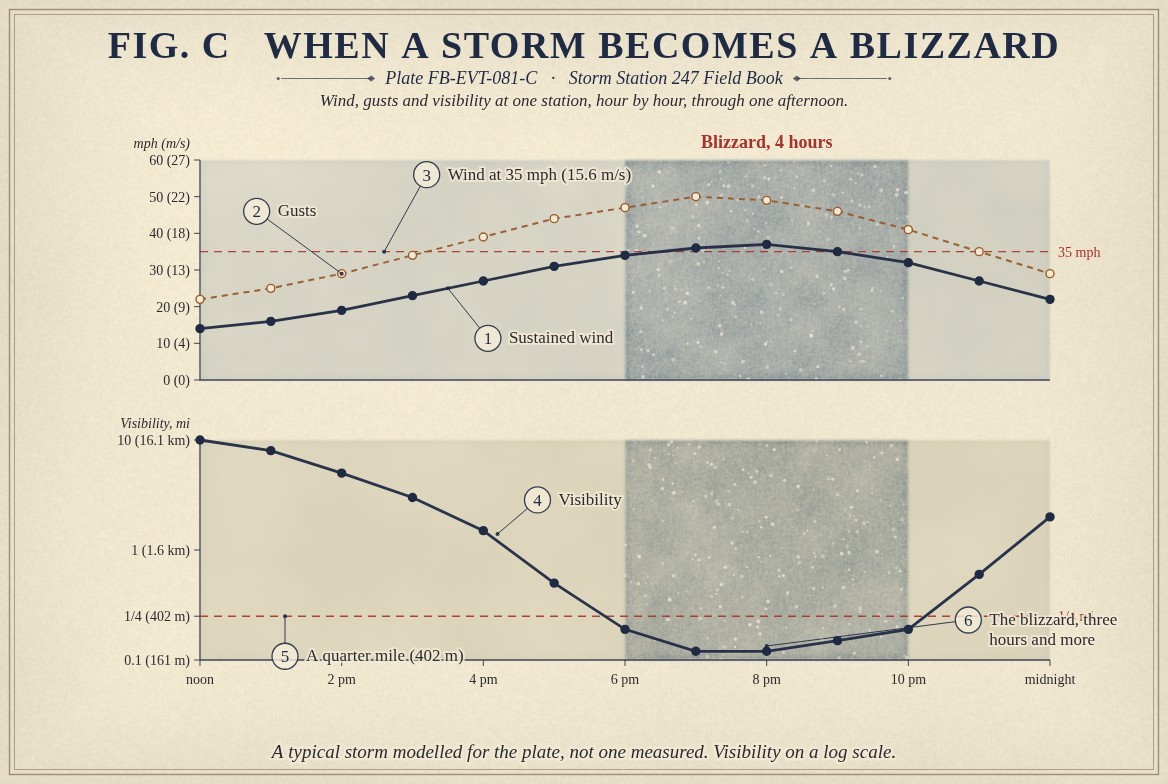
A blizzard can happen with snow falling or with none. When the storm has passed but the wind keeps blowing over loose snow already on the ground, the result is a ground blizzard: blue sky overhead, and a whiteout at head height. Fig. C follows one blizzard through an afternoon and marks the hours when both the wind and the visibility meet the definition.
What it is not
It is not a heavy snowstorm. Two feet of snow falling in light wind is a winter storm, and the Weather Service warns it as one. A blizzard can leave only a few inches of new snow behind, piled into drifts taller than a car.
It is not a snow squall. A squall is a short, violent burst of snow and wind along a cold front, over in minutes, and it has its own warning. A blizzard lasts hours.
It is not the cold, though it comes with cold. The cold makes the snow dry enough to blow, and the wind makes the cold dangerous, which is the wind chill below.
Lookalikes
- A heavy snowstorm
- Deep snow in light wind is a winter storm, not a blizzard. A blizzard can bring little new snow at all.
- Snow squall
- A short, intense burst of snow and wind along a front, lasting minutes to an hour, warned as a Snow Squall Warning.
- Whiteout
- What a blizzard does to the eye: the ground, the sky and the air all the same white, with no horizon and no shadows.
The machine
The storm that makes the wind
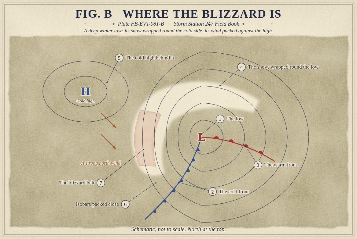
Most blizzards in the United States come from a deep winter low, Midlatitude cyclone life cycle FB-EVT-060. Fig. B draws one in plan. Snow falls on the low's cold side, wrapped around its north and west in the shape of a comma. Behind the low a dome of cold, dense air presses in from the northwest, and between the low and that high the isobars pack tight. The tighter they lie, the harder the wind blows, High wind FB-EVT-150. Where that belt of strong wind crosses the belt of snow, the storm becomes a blizzard. On the Great Plains, with hundreds of miles of open country and nothing to slow the wind, that happens more often than anywhere else in the country.
How the wind lifts snow
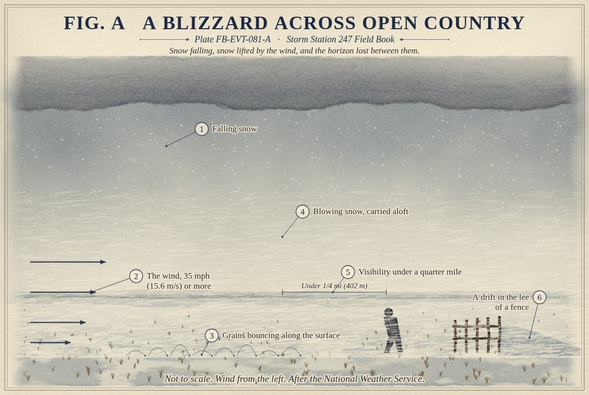
Snow lying on the ground is a bed of grains bonded lightly to each other. A wind of about 17 mph (7.7 m s⁻¹) at the standard height can break fresh, dry grains loose; older snow that has bonded, or wet snow, needs more, about 22 mph (9.9 m s⁻¹) when wet. Once loose, the grains move in two ways, and Fig. A draws both. Most hop along the surface, rising a few inches and falling back to knock more grains loose: that is saltation, and it is the drifting snow that snakes across a road. In a stronger wind, eddies lift the smallest grains high into the air and carry them for miles. That is blowing snow, and it is what fills the air to the height of a truck and above.
Cold matters because dry snow blows and wet snow sticks. The colder the snow, the weaker the bonds between the grains, and the easier the wind lifts it.
Why a quarter of a mile
Visibility falls fast in blowing snow because the air is full of small, bright grains that scatter light in every direction. The eye loses contrast long before it loses light. Under a quarter of a mile, a driver cannot see a stopped car or the edge of the road in time to act, and a person on foot can lose a building a few yards away. That is where the definition draws the line.
Where the snow goes
Wherever the wind slows, it drops what it carries. Behind a fence, a road cut, a building or a shelterbelt of trees, the snow settles into drifts, while open ground nearby is scoured bare. That is why a blizzard with little new snow can still close roads for days: the wind has moved the snow off the fields and onto the highways.
The cold of the wind
Wind takes heat from the skin much faster than still air does. The Weather Service's wind chill index measures how cold still air would have to be to take heat from bare skin as fast; its equation is below. At 10 °F (−12.2 °C) in a 35 mph wind, the wind chill is −13.6 °F (−25.4 °C). Exposed skin can freeze quickly in such conditions, Wind chill event FB-EVT-093.
The drawings
Each figure drawn as an engineering sheet, its parts numbered, to print at 11 by 17.
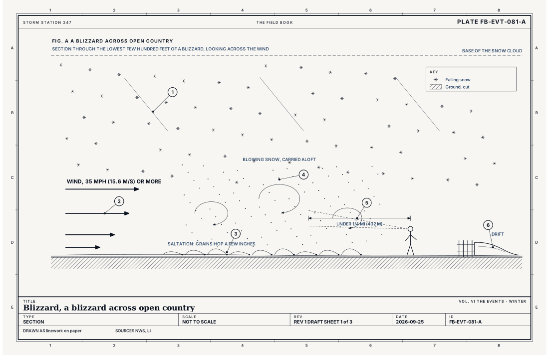
- Falling snow
- The wind, 35 mph (15.6 m s⁻¹) or more
- Grains bouncing along the surface
- Blowing snow, carried aloft
- Visibility under a quarter mile (402 m)
- A drift in the lee of a fence
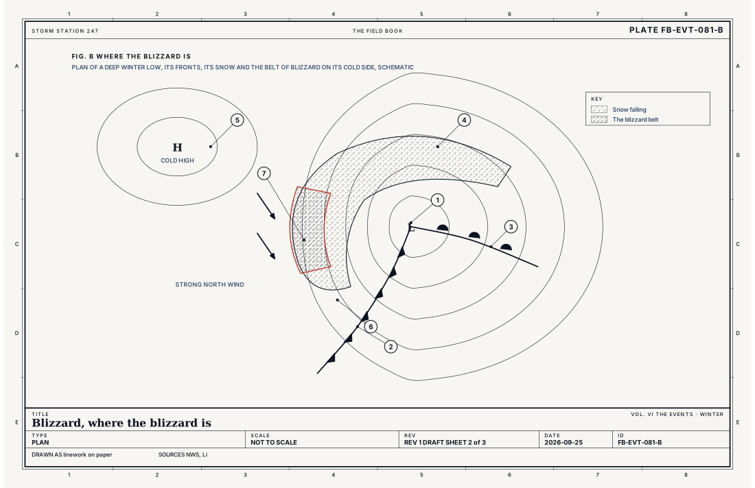
- The low
- The cold front
- The warm front
- The snow, wrapped round the low
- The cold high behind it
- Isobars packed close
- The blizzard belt
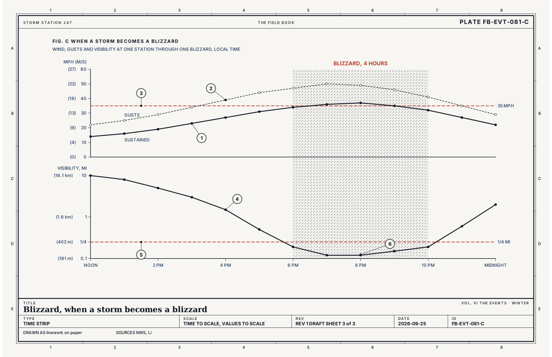
- Sustained wind
- Gusts
- Wind at 35 mph (15.6 m s⁻¹)
- Visibility
- A quarter mile (402 m)
- The blizzard, three hours and more
Ingredients
- Snow to move: falling from the storm, or already on the ground, dry and loose
- Wind: a steep pressure gradient on the cold side of a deep low, strong enough to lift the snow
- Cold: dry snow that does not stick, so the wind can pick it up and carry it
- Open country: long, unbroken fetch where nothing breaks the wind or catches the drift
Scales
- time
- three hours at the least, for a blizzard; a day or two, for the storm that brings it
- horizontal
- a region of hundreds of miles (hundreds of km) around a deep low; a ground blizzard, wherever loose snow lies under a strong wind
- vertical
- the blowing snow, from the surface to a few hundred feet (about 100 m); the falling snow, from clouds several miles up
- orlanski
- meso-alpha to synoptic
Equations
The wind chill
- the wind chill temperature, °F
- the air temperature, °F
- the wind speed at 33 ft (10 m), mph
Assumes The National Weather Service's 2001 index, for air temperatures at or below 50 °F (10 °C) and winds above 3 mph; it describes the heat lost from bare skin on the face, walking into the wind, in darkness.
Working form At 10 °F (−12.2 °C) in a 35 mph (15.6 m s⁻¹) wind, the wind chill is −13.6 °F (−25.4 °C): the bare face loses heat as fast as it would at −13.6 °F in still air.
Signatures
- sounding
- a deep cold layer near the ground; strong wind within a few thousand feet of the surface behind the low
- surface
- pressure rising fast behind the low; 6 mb or more in three hours; wind gusting past 35 mph; visibility dropping under a quarter mile in snow
- satellite
- a comma cloud wrapped around a deep low; a clear slot behind it where a ground blizzard can still blow
- radar
- bands of snow on the low's cold side; blowing snow near the radar that is seen as clutter rather than precipitation
The numbers
| Quantity | Value, and the kind of number it is |
|---|---|
| Blizzard Warning | Sustained wind or frequent gusts of 35 mph (15.6 m s⁻¹) or more, with considerable falling or blowing snow frequently cutting the visibility to less than a quarter of a mile (402 m), for three hours or longerStandard, Directive 10-513 |
| Ground blizzard | The same wind and visibility with no snow falling: snow already on the ground, lifted by the windStandard, Directive 10-513 |
| Winter Storm Warning | Heavy snow, sleet or freezing rain that a local office judges hazardous; commonly 6 in (15 cm) or more of snow in 12 hours, varying by officeTypical, Directive 10-513 |
| Threshold for blowing dry snow | A wind of about 17 mph (7.7 m s⁻¹) at 33 ft (10 m), and more for older or wetter snow, about 22 mph (9.9 m s⁻¹) when wetTypical, Li 1997 |
| Wind chill index | Valid at or below 50 °F (10 °C) with wind above 3 mph (1.3 m s⁻¹)Standard, Wind Chill Temperature Index (2001) |
How the station sees it
A blizzard is defined by what the airport stations measure every minute: the wind, the gusts and the visibility. The visibility sensor on an airport station shines a beam through a small volume of air and measures how much light the snow scatters back, and from that it estimates how far a person could see. The wind is measured at 33 ft (10 m), above most of the blowing snow.
What the stations do not measure well in a blizzard is the snowfall itself. Wind blows snow out of a gauge before it can be caught, and blows it into drifts beside the snow board. A blizzard's snowfall total is an estimate, and the observer's remarks about drifting often say more than the number.
Road weather stations along the highways report the wind and the visibility where the blizzard does its harm, and state road agencies close roads when they cross their own limits.
- Airport weather stations: the wind, the gusts and the visibility, every minute
- Road weather stations: the wind and the visibility along the highways, where a blizzard closes them
- Cooperative observers: the snowfall and the depth once a day, the drifting written in the remarks
How it is warned
A Winter Storm Watch is issued a day or two ahead when a significant winter storm is possible. A Blizzard Warning is issued when blizzard conditions are expected or occurring: a sustained wind or frequent gusts of 35 mph, with snow cutting the visibility under a quarter of a mile, for three hours or longer. A Winter Storm Warning covers heavy snow or ice without the wind.
In a blizzard, do not travel. If already on the road and stranded, stay with the vehicle, which is easier to find than a person on foot; keep the exhaust pipe clear of snow; run the engine for short spells only; and tie something bright to the antenna. At home, keep a supply of food, water, medicine and heat for several days without power. Cover all exposed skin when going out, even for a short distance.
| VTEC | Phenomenon | The alerts that carry it |
|---|---|---|
BZ | blizzard | Blizzard Warning |
WS | winter storm | Winter Storm Warning; Winter Storm Watch |
See also
- High wind FB-EVT-150
- Midlatitude cyclone life cycle FB-EVT-060
- Nor'easter FB-EVT-066
- Wind chill event FB-EVT-093
- Snow FB-WAT-012
- Snowpack strata FB-WAT-031
- How to read a warning FB-STN-001
Sources
- National Weather Service. Directive 10-513, WFO Winter Weather Products Specification.
- National Weather Service. Wind Chill Temperature Index (2001).
- Li, L. and J. W. Pomeroy. Estimates of Threshold Wind Speeds for Snow Transport Using Meteorological Data, Journal of Applied Meteorology 36 (1997).
- National Weather Service. Watch, Warning, Advisory definitions.
- American Meteorological Society. Glossary of Meteorology.
Definition after the Directive 10-513, WFO Winter Weather Products Specification. Plate FB-EVT-081, revision 1, 2026-09-25. The number is permanent; cite it.