What it is
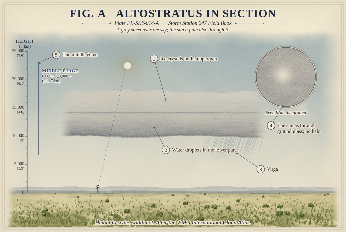
Altostratus is a greyish or bluish sheet or layer covering all or much of the sky, fibrous or even, in the middle étage, 6,600 to 23,000 ft (2 to 7 km) in the middle latitudes, Cloud classification FB-SKY-001. In its thinner parts the sun shows as through ground glass: a pale, blurred disc that casts no sharp shadow. It makes no halo.
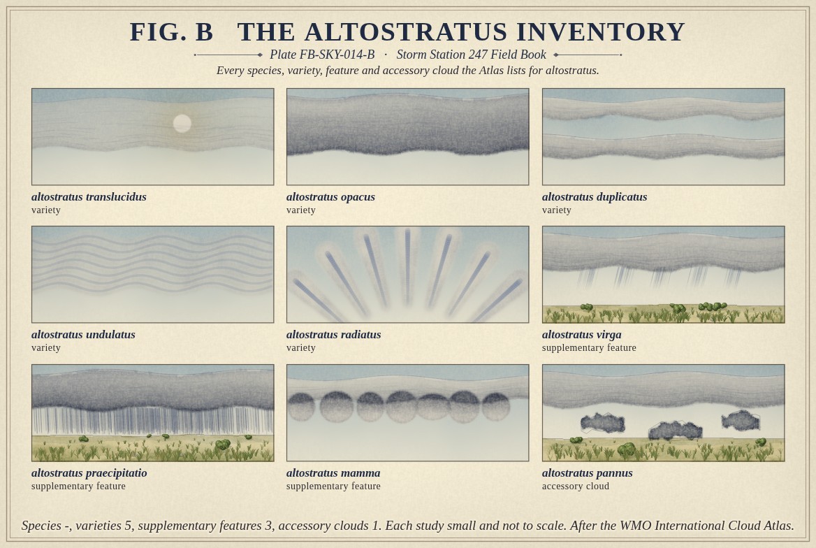
The Atlas gives altostratus no species; a sheet has no shape to sort by. It lists five varieties: translucidus and opacus for a sheet that shows or hides the sun, duplicatus for two layers, and undulatus and radiatus for waves and bands. Three supplementary features, virga, praecipitatio and mamma, and one accessory cloud, pannus, can come with it. Fig. B draws each one.
What it is not
It is not cirrostratus, Cirrostratus FB-SKY-012, which is thinner and higher: shadows stay sharp under it and it often makes a halo. Altostratus never makes a halo, because it is too thick for light to pass cleanly through its crystals.
It is not nimbostratus, Nimbostratus FB-SKY-015, which is darker, hides the sun everywhere and has rain or snow falling from it steadily. The line between the two is crossed when a sheet thickens, and one often becomes the other within hours. It is not stratus, which is low, and even, with drizzle rather than rain.
Lookalikes
- Cirrostratus
- Thin enough for shadows, and makes a halo.
- Nimbostratus
- Darker, hides the sun everywhere, and rain or snow falls steadily.
- Stratus
- Low and uniform, with drizzle rather than rain.
The machine
Altostratus forms where a deep layer of moist air is lifted broadly and slowly over a wide area, most often over the sloping surface of a warm front or ahead of a low. The lift is gentle and wide, so the cloud is a sheet; it is deep, so the sheet spans heights where the air is below freezing and heights where it may not be.
Fig. A draws the sheet in two parts: ice crystals in its upper part, water droplets in its lower. Snow and rain begin to fall from it, and at first they evaporate in the drier air below as virga, drawn beneath one side. As the lifting continues, the air under the sheet moistens, the base lowers, and what falls starts to reach the ground. The sheet is then turning into nimbostratus.
The usual order of a warm front's sky, read from its first cloud, is cirrus, then cirrostratus, then altostratus, then nimbostratus, over half a day or so. Altostratus is the stage at which the sun goes watery.
The drawings
Each figure drawn as an engineering sheet, its parts numbered, to print at 11 by 17.
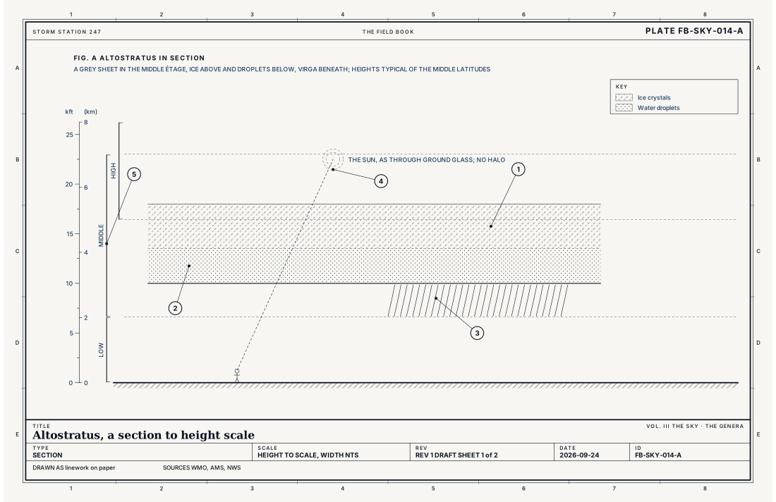
- Ice crystals in the upper part
- Water droplets in the lower part
- Virga
- The sun as through ground glass; no halo
- The middle étage
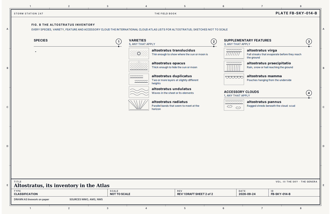
- Species, at most one
- Varieties, any that apply
- Supplementary features, any that apply
- Accessory clouds, any that apply
Ingredients
- A broad, slow lifting of a deep layer of moist air, as over a warm front
- Ice crystals in the upper part of the sheet and water droplets in the lower part
- Rain or snow falling from it, often evaporating before it reaches the ground
Scales
- time
- hours; it lowers and thickens over half a day ahead of a front
- horizontal
- hundreds of miles
- vertical
- 3,300 to 10,000 ft (1 to 3 km) deep, or more
- orlanski
- synoptic
Signatures
- surface
- an overcast in the sky report when it is below 12,000 ft; light rain or snow may begin
- satellite
- a wide cold sheet, often the front edge of a storm's cloud shield
- radar
- light echo aloft; virga shows as echo that does not reach the ground
The numbers
| Quantity | Value, and the kind of number it is |
|---|---|
| Abbreviation | AsStandard, International Cloud Atlas |
| Étage | Middle: 6,600 to 23,000 ft (2 to 7 km) in the middle latitudesStandard, International Cloud Atlas |
| Made of | Ice crystals above and water droplets below, with raindrops or snowflakesStandard, International Cloud Atlas |
| The sun through it | Seen dimly, as through ground glass; no haloStandard, International Cloud Atlas |
| Species | -Standard, International Cloud Atlas |
| Varieties | 5: translucidus, opacus, duplicatus, undulatus, radiatusStandard, International Cloud Atlas |
| Supplementary features | 3: virga, praecipitatio, mammaStandard, International Cloud Atlas |
| Accessory clouds | 1: pannusStandard, International Cloud Atlas |
| Airport ceilometer | Cloud bases to 12,000 ft (3.7 km) overheadStandard, Automated Surface Observing System (ASOS) User's Guide |
How the station sees it
An airport station measures cloud overhead with a laser ceilometer to 12,000 ft (3.7 km). Altostratus below that height appears in the sky report as an overcast or broken layer at its base height; the station does not name the genus. Light rain or snow may begin in the report as the sheet thickens. On radar, snow falling from the sheet shows as echo aloft that does not reach the ground until the air below moistens.
- Airport weather stations: the cover and height of each layer overhead, to 12,000 ft
How it is warned
Altostratus is not warned. It is the cloud of the hours before steady rain or snow, and the warnings that follow it, for heavy snow, freezing rain or flooding, are for what falls from the nimbostratus it becomes, Snow FB-WAT-012 and Rain FB-WAT-010.
See also
- Cloud classification FB-SKY-001
- Cirrostratus FB-SKY-012
- Altocumulus FB-SKY-013
- Nimbostratus FB-SKY-015
- Rain FB-WAT-010
- Snow FB-WAT-012
Sources
- World Meteorological Organization. International Cloud Atlas.
- American Meteorological Society. Glossary of Meteorology.
- National Weather Service. Automated Surface Observing System (ASOS) User's Guide.
Definition after the International Cloud Atlas. Plate FB-SKY-014, revision 1, 2026-09-24. The number is permanent; cite it.