What it is
Two kinds of cloud form far above the weather, and the Atlas names them apart from the ten genera as upper atmospheric clouds, Cloud classification FB-SKY-001.
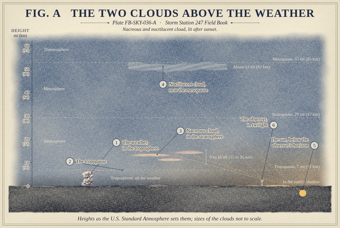
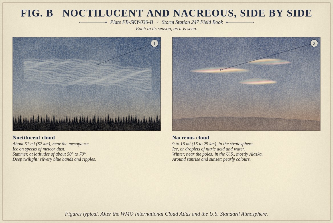
Noctilucent cloud forms near 51 mi (82 km), just below the mesopause, the coldest level in the atmosphere, Atmosphere in section FB-ENG-001. It is thin ice, seen only in summer, at latitudes of about 50° to 70°, as silvery blue bands and ripples glowing in a dark sky long after sunset. Its name means night shining. It was first described in 1885, two years after the eruption of Krakatoa, by observers who were watching that eruption's vivid twilights, and it has been reported more often, and farther from the poles, in the decades since.
Nacreous cloud forms in the stratosphere, near 9 to 16 mi (15 to 25 km), in the polar winter. It is seen shortly before sunrise and after sunset, in vivid pearly colours that barely move, and is also called mother of pearl cloud. Fig. B sets the two side by side.
What it is not
Neither is cirrus. Cirrus is lit only while the sun is up where the observer stands; noctilucent cloud is still bright when every lower cloud has turned dark. Nacreous colours are brighter and steadier than the iridescence on the edge of an ordinary altocumulus, Corona, iridescence and glory FB-SKY-052. And neither is aurora, which is light made in the upper air itself and seen in full night, Aurora FB-SKY-070.
Lookalikes
- Cirrus
- Lit only while the sun is up where the observer is; noctilucent cloud glows after the lower clouds have gone dark
- Iridescent altocumulus
- Also colourful near the sun, but moving, and lower; nacreous colours are brighter and almost still
- Aurora
- Light made in the upper air itself, not sunlight on cloud, and seen in full night
The machine
Both need extreme cold. The summer mesopause over the high latitudes is the coldest place in the atmosphere, near -210 °F (-135 °C), because air rising there in summer expands and cools. At that cold the trace of water vapour present freezes onto specks of meteor dust. Nacreous cloud needs the stratosphere below about -108 °F (-78 °C), which it reaches only in the long polar night; its particles are ice, or droplets of nitric acid and water.
Fig. A shows why both are seen in twilight. With the sun a few degrees below the observer's horizon, the ground and the lower air are in the earth's shadow, but the air far overhead is still in sunlight. For noctilucent cloud the best time is when the sun is roughly 6° to 16° below the horizon: dark enough below for the cloud to show, high enough above for it to be lit.
The nacreous cloud's small, even particles bend sunlight into its colours. Its cousins, the polar stratospheric clouds of nitric acid, are where the chemistry that thins the ozone layer each polar spring takes place.
The drawings
Each figure drawn as an engineering sheet, its parts numbered, to print at 11 by 17.
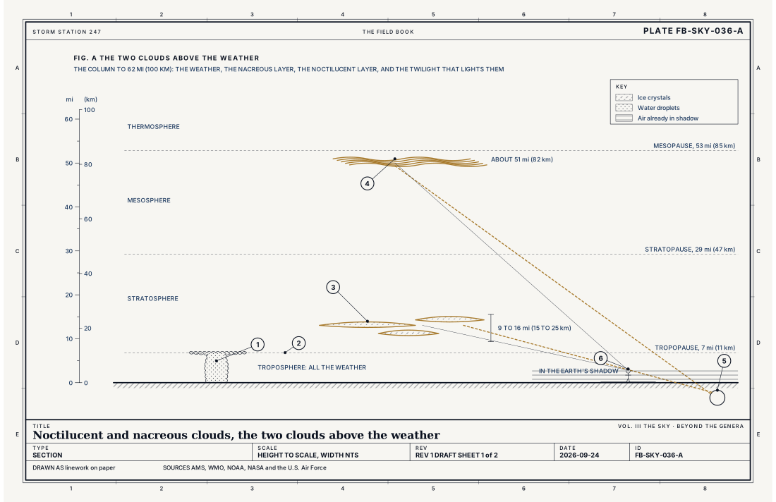
- The weather, in the troposphere
- The tropopause
- Nacreous cloud, in the stratosphere
- Noctilucent cloud, near the mesopause
- The sun, below the observer's horizon
- The observer, in twilight
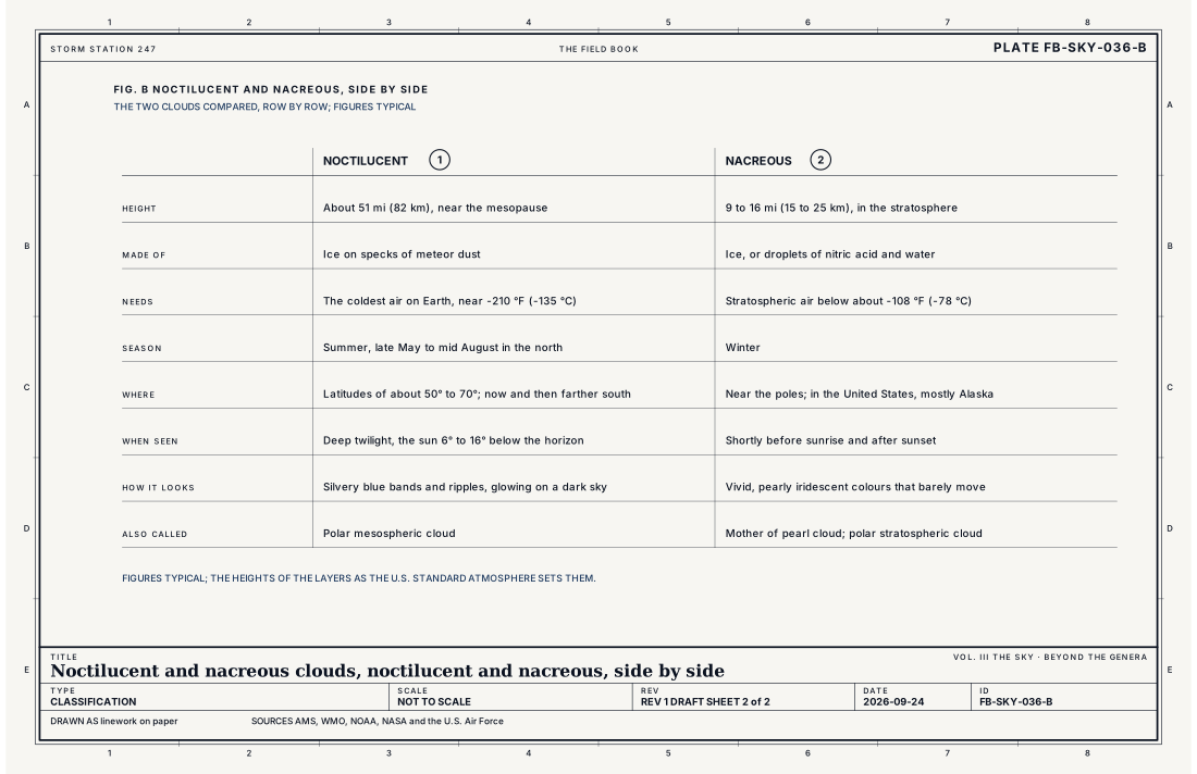
- Noctilucent cloud
- Nacreous cloud
Ingredients
- Extreme cold: the summer polar mesopause is the coldest place in the atmosphere; nacreous cloud needs the stratosphere colder than about -108 °F (-78 °C)
- A trace of water vapour, and particles to freeze on: meteor dust high up
- Twilight, with the sun below the observer's horizon but still shining on the cloud
Scales
- time
- an hour or two of twilight; the clouds themselves can last for days
- horizontal
- hundreds of miles of banded sheet
- vertical
- a thin layer, under a mile (1.6 km) deep for noctilucent cloud
- orlanski
- synoptic
Signatures
- satellite
- polar mesospheric cloud seen from orbit as a bright ring around the summer pole; polar stratospheric cloud from space borne lidar in the polar winter
- surface
- none: both are far above every instrument at a weather station
The numbers
| Quantity | Value, and the kind of number it is |
|---|---|
| Noctilucent height | About 51 mi (82 km), near the mesopauseTypical, Glossary of Meteorology |
| Mesopause | About 53 mi (85 km) in the standard atmosphereStandard, U.S. Standard Atmosphere |
| Noctilucent season | Summer; late May to mid August in the northern hemisphere, at latitudes of about 50° to 70°Typical, Glossary of Meteorology |
| Noctilucent temperature | Near -210 °F (-135 °C)Typical, Wallace 2006 |
| Nacreous height | 9 to 16 mi (15 to 25 km), in the stratosphereTypical, Glossary of Meteorology |
| Nacreous temperature | Below about -108 °F (-78 °C)Typical, Wallace 2006 |
| Seen | In twilight, when the sun is roughly 6° to 16° below the horizon for noctilucent cloudTypical, Glossary of Meteorology |
How the station sees it
No weather station sees either: both are far above every instrument on the ground, and above the reach of any airport's ceilometer. They are known from observers on the ground in twilight, and from satellites and lidar, which see noctilucent cloud as a bright ring around the summer pole.
How it is warned
Neither is warned or affects the weather below. In the United States, noctilucent cloud is seen most often from the northern states in June and July, and has been seen farther south in recent summers; nacreous cloud is seen mostly from Alaska in winter. Both are worth looking for in the northern sky in deep twilight.
See also
- Cloud classification FB-SKY-001
- Atmosphere in section FB-ENG-001
- Corona, iridescence and glory FB-SKY-052
- Aurora FB-SKY-070
- Composition of air FB-ENG-002
Sources
- American Meteorological Society. Glossary of Meteorology.
- World Meteorological Organization. International Cloud Atlas.
- NOAA, NASA and the U.S. Air Force. U.S. Standard Atmosphere, 1976.
- Wallace, J. M. and P. V. Hobbs. Atmospheric Science, An Introductory Survey, 2nd ed. (2006).
Definition after the Glossary of Meteorology. Plate FB-SKY-036, revision 1, 2026-09-24. The number is permanent; cite it.