What it is
A high wind is a wind strong enough, and lasting long enough, to do damage on its own. It snaps branches and whole trees, brings down power lines, lifts roofing, and rolls trucks and trailers on open highways. It needs no thunderstorm. It can blow under a clear sky for a day or more, across several states at once.
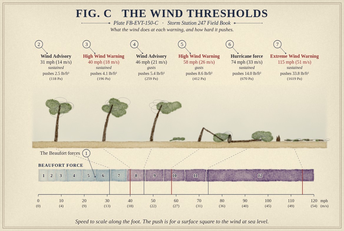
The Weather Service draws the line in numbers. A High Wind Warning means a sustained wind of 40 mph (18 m s⁻¹) or more for an hour or longer, or gusts of 58 mph (26 m s⁻¹) or more for any length of time. A Wind Advisory covers the step below it: a sustained 31 to 39 mph, or gusts of 46 to 57 mph. Fig. C sets these on one scale with the Beaufort forces the sea has used for two hundred years.
What it is not
It is not a thunderstorm's wind. A downburst or a squall line can bring gusts of 58 mph or more, but from one storm, over a few miles, for minutes. That is warned as a Severe Thunderstorm Warning, and its plate is Severe wind FB-EVT-016. A high wind comes from the weather of a whole region.
It is not a hurricane's wind. Inside a tropical storm or a hurricane the wind is warned by the hurricane products: Hurricane FB-EVT-043. The one wind warning that belongs to a hurricane is the Extreme Wind Warning, for the core of a major hurricane about to arrive.
It is not wind chill. A strong wind on a cold day makes the air feel colder, and that is warned as cold: Wind chill event FB-EVT-093.
Lookalikes
- Severe thunderstorm wind
- A downburst or a squall line brings gusts of 58 mph or more too, but from one storm, for minutes, and it is warned as a Severe Thunderstorm Warning, Severe wind FB-EVT-016.
- Tropical storm or hurricane wind
- Inside a tropical cyclone the wind is warned by the hurricane products, not by the high wind products, Hurricane FB-EVT-043.
- Wind chill
- Wind makes cold air feel colder. That is warned as cold, not as wind, Wind chill event FB-EVT-093.
The machine
Pressure drives it
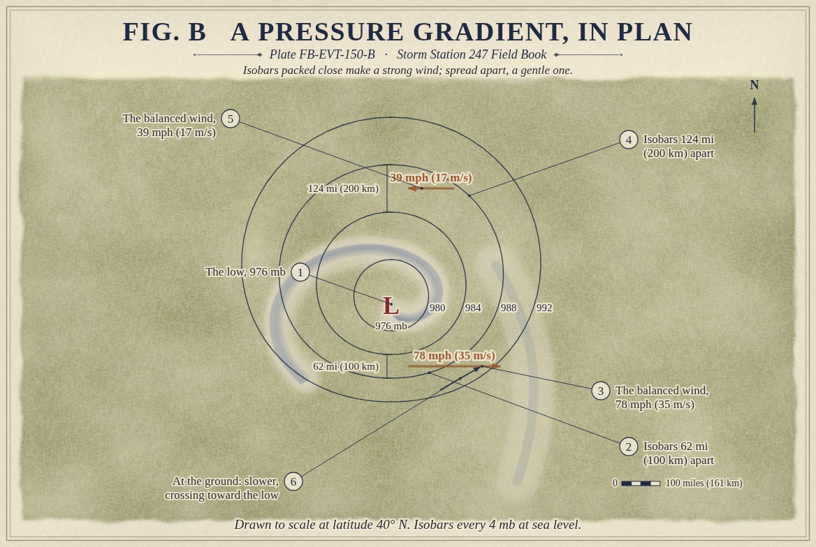
Air moves from high pressure toward low pressure. On a map the isobars, the lines of equal pressure, show where the difference is steep: the closer together they lie, the harder the air is pushed. Away from the ground the Earth's turning bends that moving air until it runs along the isobars instead of across them, and the wind settles where the push of the pressure and the turn of the Earth balance. That balanced wind is the geostrophic wind, and its equation is below.
The balance makes the spacing of the isobars a measure of the wind. At latitude 40°, isobars 4 mb apart and 124 miles (200 km) from each other balance a wind of 39 mph (17 m s⁻¹). Bring them to 62 miles (100 km) and the wind is 78 mph (35 m s⁻¹). Fig. B draws both, around one deep low. The deeper the low, and the stronger the high beside it, the tighter the isobars pack. The balance itself is drawn in Geostrophic and thermal wind FB-ENG-009.
Friction slows it at the ground
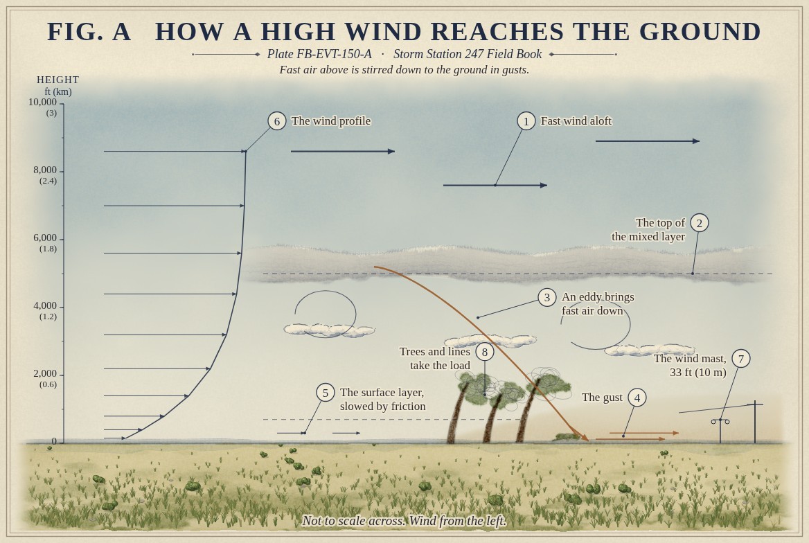
That is the wind a little way up. At the ground, friction with trees, buildings and rough land slows the air and turns it partly across the isobars toward the low. Over land the surface wind is often about half the balanced wind above it. So a strong gradient alone does not bring a high wind to the ground. Something has to bring the fast air down.
Mixing brings it down
What brings it down is mixing. On a sunny afternoon the ground heats the air above it, and that air rises and overturns in a layer that can be several thousand feet deep. In the cold air behind a strong front, the air is stirred the same way. Within that layer, eddies carry parcels of air up and down. A parcel carried down from the fast wind at the top of the layer arrives at the ground still moving fast, and that is a gust. Fig. A draws it.
This is why a windy day is often windiest in the afternoon and calms at dusk. When the sun sets, the ground cools and the lowest air goes still, cut off from the fast wind above it, which blows on overhead through the night.
Terrain concentrates it
Mountains make the strongest of these winds. Air forced over a range can plunge down the far side, warming as it sinks, and reach the foot of the slope far faster than it blew over the crest. That is the downslope windstorm of the Front Range, the chinook, and the Santa Ana of Southern California. Three plates draw them: Downslope windstorm FB-EVT-156, Chinook and foehn FB-EVT-152 and Santa Ana, Diablo and Sundowner FB-EVT-153. Air squeezed through a gap in the mountains speeds up the same way a river speeds through a narrow channel: Bora and gap wind FB-EVT-154.
Why a gust does the damage
The push of the wind on a surface grows with the square of its speed. The second equation below gives it. At 40 mph (18 m s⁻¹) the wind pushes about 4.1 lb on every square foot (196 Pa) of a surface square to it. A gust of 58 mph (26 m s⁻¹) pushes 8.6 lb (412 Pa): about one and a half times the speed, and more than twice the load. That is why the gust sets the warning, and why a tree that stands all day in a steady wind falls in one gust. Ground already soaked by rain holds roots less well, and trees in full leaf catch more wind, so the same wind brings down more trees in summer or after a wet week.
The drawings
Each figure drawn as an engineering sheet, its parts numbered, to print at 11 by 17.
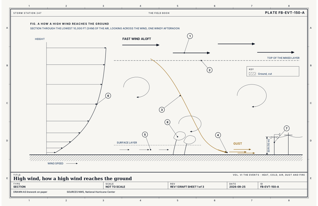
- Fast wind aloft
- The top of the mixed layer
- An eddy carrying fast air down
- A gust at the ground
- The surface layer, slowed by friction
- The wind profile
- The wind mast, 33 ft (10 m)
- Trees and lines, taking the load
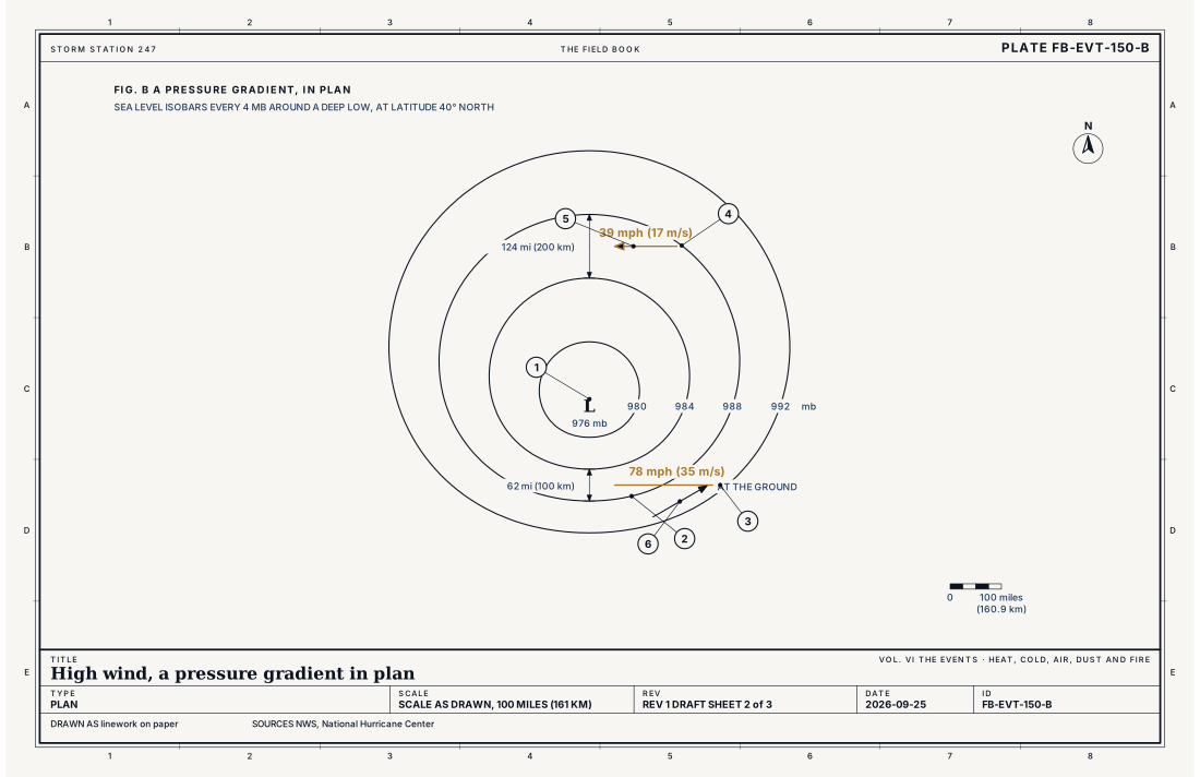
- The low, 976 mb
- Isobars 62 mi (100 km) apart
- The balanced wind there, 78 mph (35 m s⁻¹)
- Isobars 124 mi (200 km) apart
- The balanced wind there, 39 mph (17 m s⁻¹)
- The surface wind, crossing toward the low
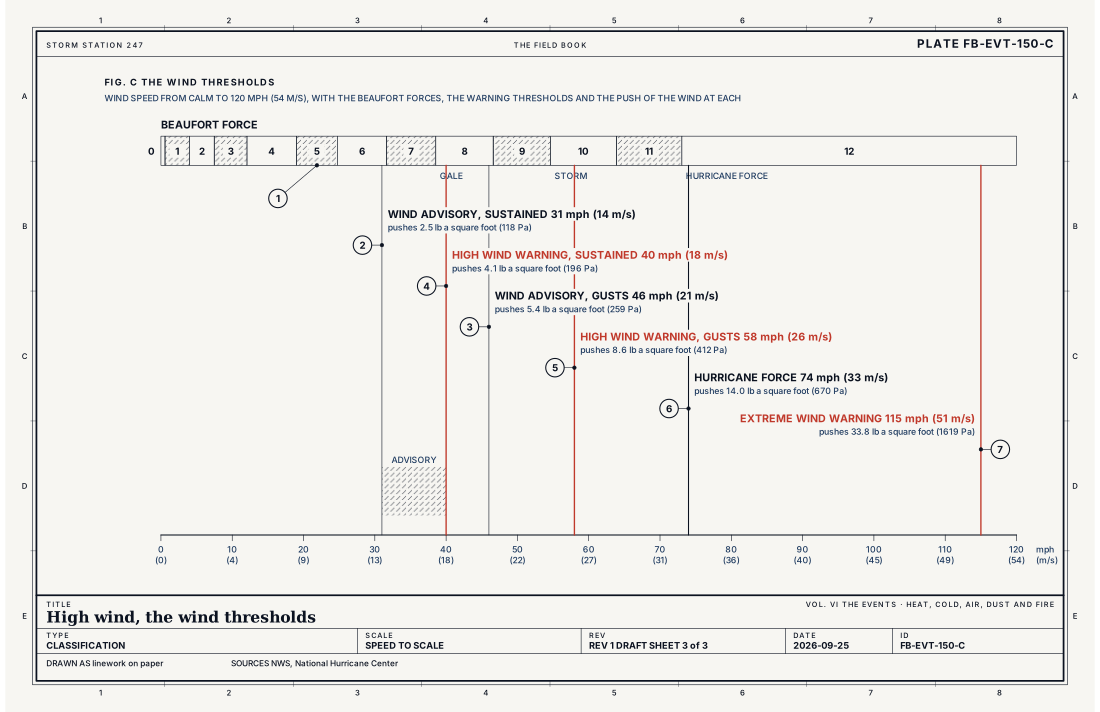
- The Beaufort forces, 0 to 12
- Wind Advisory, sustained 31 mph (14 m s⁻¹)
- Wind Advisory, gusts 46 mph (21 m s⁻¹)
- High Wind Warning, sustained 40 mph (18 m s⁻¹)
- High Wind Warning, gusts 58 mph (26 m s⁻¹)
- Hurricane force, 74 mph (33 m s⁻¹)
- Extreme Wind Warning, 115 mph (51 m s⁻¹)
Ingredients
- A steep pressure gradient: isobars packed close together around a deep low, or between a low and a strong high
- Fast wind a little way above the ground, at the top of the layer that can mix down
- Mixing: a well stirred layer, by afternoon heating or cold air behind a front, that brings that fast air to the surface in gusts
- Or terrain: air forced down the lee of a range, or squeezed through a gap, speeding up as it goes
Scales
- time
- hours to a day or two, for one event
- horizontal
- a valley or a coast, for a downslope or gap wind; hundreds of miles (hundreds of km), for a deep storm
- vertical
- the lowest 3,000 to 10,000 ft (1 to 3 km), where fast air aloft is mixed to the ground
- orlanski
- meso-beta to synoptic
Equations
The geostrophic wind
- the wind that balances the pressure gradient against the turning of the Earth, m s⁻¹
- the density of the air, kg m⁻³
- the Coriolis parameter, s⁻¹
- the difference in pressure between two isobars, Pa
- the distance between them, m
- the rate the Earth turns, 7.292 × 10⁻⁵ s⁻¹
- the latitude
Assumes Straight isobars, no friction and no change with time; it describes the wind above the lowest few thousand feet well, and the wind at the ground less well, because friction slows it there.
Working form At latitude 40° (f = 9.37 × 10⁻⁵ s⁻¹) and sea level density 1.225 kg m⁻³, isobars 4 mb apart over 62 miles (100 km) balance a wind of 78 mph (35 m s⁻¹); the same isobars 124 miles (200 km) apart balance 39 mph (17 m s⁻¹). Halve the spacing and the wind doubles.
The push of the wind
- the dynamic pressure of the wind on a surface square to it, Pa
- the density of the air, kg m⁻³
- the wind speed, m s⁻¹
Assumes Air brought to rest against a flat surface; a real tree, sign or roof takes a fraction or a multiple of it according to its shape.
Working form At sea level density, 40 mph (17.9 m s⁻¹) pushes 4.1 lb on every square foot (196 Pa); a 58 mph (25.9 m s⁻¹) gust pushes 8.6 lb (412 Pa), more than twice as much for less than one and a half times the speed.
Signatures
- sounding
- a deep well mixed layer; a strong wind at its top; 50 knots or more within a few thousand feet of the ground
- surface
- pressure rising or falling 6 mb or more in three hours; gusts well above the sustained wind; a sudden shift and rise of the wind behind a cold front
- satellite
- a tight comma cloud wrapping around a deep low; dust lifted from dry ground; a clear band in the lee of a range
- radar
- a fast inbound or outbound velocity close to the radar in clear air; the wind itself carrying insects and dust past the beam
The numbers
| Quantity | Value, and the kind of number it is |
|---|---|
| High Wind Warning | Sustained wind of 40 mph (18 m s⁻¹) or more for an hour or longer, or gusts of 58 mph (26 m s⁻¹) or more for any length of time, occurring or expectedStandard, Directive 10-515 |
| Wind Advisory | Sustained wind of 31 to 39 mph (14 to 17 m s⁻¹) for an hour or longer, or gusts of 46 to 57 mph (21 to 25 m s⁻¹)Typical, Directive 10-515 |
| High Wind Watch | High wind warning criteria are possible, usually 12 to 48 hours aheadTypical, Directive 10-515 |
| Local criteria | Some offices, in the mountains, on the coasts, in Alaska and in Hawaii, set higher or lower numbers that suit their groundTypical, Directive 10-515 |
| Extreme Wind Warning | Sustained surface wind of 115 mph (51 m s⁻¹, 100 knots) or more in a major hurricane, expected within the hourStandard, Directive 10-511 |
| Hurricane force | Sustained wind of 74 mph (33 m s⁻¹) or moreStandard, The Saffir-Simpson Hurricane Wind Scale |
| Gale | Beaufort force 8: 39 to 46 mph (17.2 to 20.7 m s⁻¹, 34 to 40 knots)Standard, Glossary of Meteorology |
| Sustained wind | At an airport station, the average over two minutesStandard, Automated Surface Observing System (ASOS) User's Guide |
| Gust | At an airport station, the highest five second average in the last ten minutes, reported when it beats the sustained wind by 10 knots, about 12 mph, or moreStandard, Automated Surface Observing System (ASOS) User's Guide |
| Measuring height | The wind is measured 33 ft (10 m) above open, level groundStandard, Guide to Instruments and Methods of Observation (WMO-No. 8) |
How the station sees it
Wind is measured 33 ft (10 m) above open, level ground, the standard height, so that one station can be compared with another. Lower, among trees or buildings, the same wind reads slower. The airport weather stations report the sustained wind as an average over two minutes, and the gust as the highest five second average in the last ten minutes. They report the gust when it beats the sustained wind by 10 knots, about 12 mph, or more.
A warning is judged against both numbers, which is why a report can meet the warning on its gusts while its sustained wind is well under 40 mph. The instrument pages on this site show both for every station that reports wind, and road weather stations along the highways report the wind where high profile vehicles are most at risk.
Before the wind arrives, the signs are in the pressure. A fall or rise of 6 mb or more in three hours, a strong wind in the morning sounding at the top of the layer the afternoon will mix, or a deep low forecast to pass nearby, each gives a forecaster hours or days of warning.
- Airport weather stations: the sustained wind and the gusts, every minute, 33 ft (10 m) up
- Road weather stations: the wind along the highways, where a high wind rolls trucks
- Every station on the map: all the instruments that report wind, ranked on how well they report
How it is warned
A High Wind Watch is issued when warning level winds are possible, usually 12 to 48 hours ahead. A High Wind Warning is issued when they are occurring or expected: a sustained 40 mph for an hour, or gusts of 58 mph. A Wind Advisory is issued for the step below. Some offices set other numbers that suit their ground: higher in the mountains and on the coasts, where strong wind is usual, and lower where trees and buildings are not built for it. An Extreme Wind Warning is issued in a major hurricane, when a sustained surface wind of 115 mph (51 m s⁻¹, 100 knots) or more is expected within the hour.
In a high wind, stay away from trees and from windows on the windward side of a building. Secure what can blow away before the wind arrives. Treat every downed power line as live. Drivers of high profile vehicles and anyone towing a trailer should stay off exposed roads and bridges until the warning ends.
| VTEC | Phenomenon | The alerts that carry it |
|---|---|---|
HW | high wind | High Wind Warning; High Wind Watch |
WI | wind | Wind Advisory |
EW | extreme wind | Extreme Wind Warning |
See also
- Gradient wind event FB-EVT-151
- Chinook and foehn FB-EVT-152
- Santa Ana, Diablo and Sundowner FB-EVT-153
- Bora and gap wind FB-EVT-154
- Downslope windstorm FB-EVT-156
- Severe wind FB-EVT-016
- Hurricane FB-EVT-043
- Gale, storm and hurricane force marine wind FB-EVT-113
- Geostrophic and thermal wind FB-ENG-009
- What an instrument is FB-INS-001
- How to read a warning FB-STN-001
Sources
- National Weather Service. Directive 10-515, WFO Non-Precipitation Weather Products Specification.
- National Weather Service. Directive 10-511, WFO Severe Weather Products Specification.
- National Hurricane Center. The Saffir-Simpson Hurricane Wind Scale.
- American Meteorological Society. Glossary of Meteorology.
- National Weather Service. Automated Surface Observing System (ASOS) User's Guide.
- World Meteorological Organization. Guide to Instruments and Methods of Observation (WMO-No. 8).
- Wallace, J. M. and P. V. Hobbs. Atmospheric Science, An Introductory Survey, 2nd ed. (2006).
Definition after the Directive 10-515, WFO Non-Precipitation Weather Products Specification. Plate FB-EVT-150, revision 1, 2026-09-25. The number is permanent; cite it.