What it is
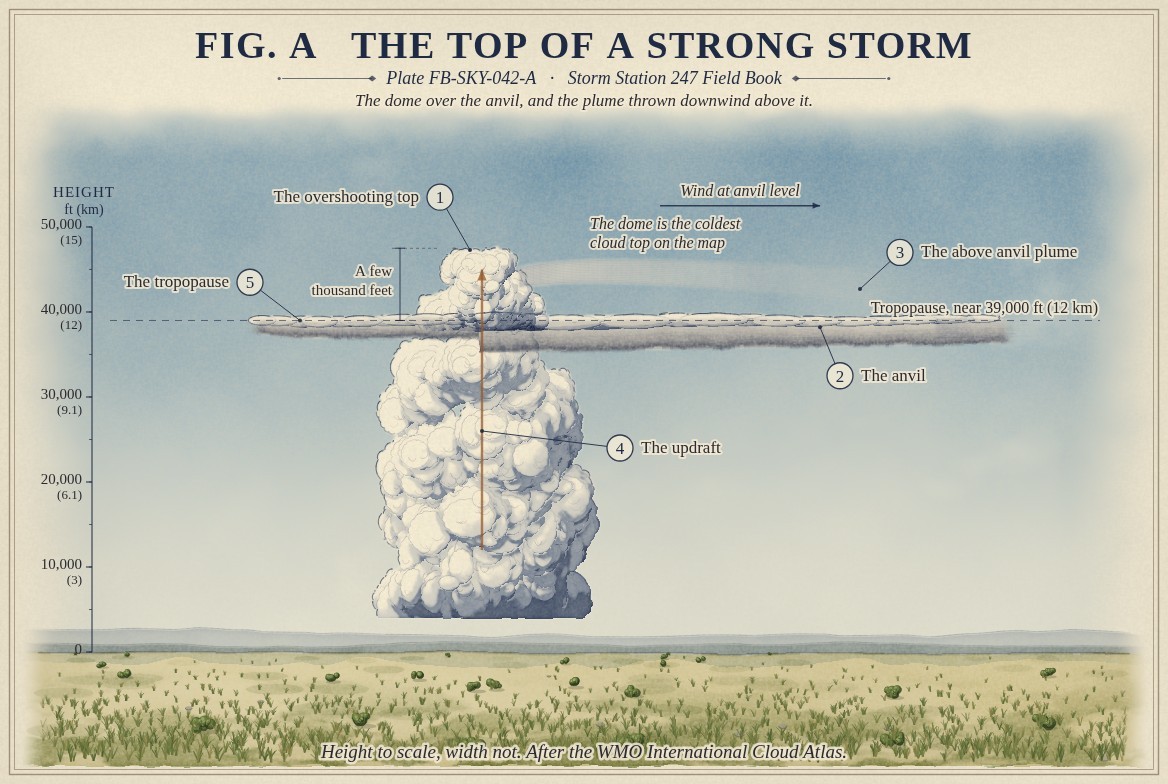
An overshooting top is a dome of cloud standing above a thunderstorm's anvil, directly over its updraft. The anvil spreads out flat along the tropopause, near 39,000 ft (12 km) in the middle latitudes in summer, because that is where rising air stops being lighter than the air around it. An updraft strong enough is still rising fast when it gets there, and its momentum carries it on, a few thousand feet higher, before it slows and sinks back. Fig. A draws the dome, the anvil and the updraft beneath them.
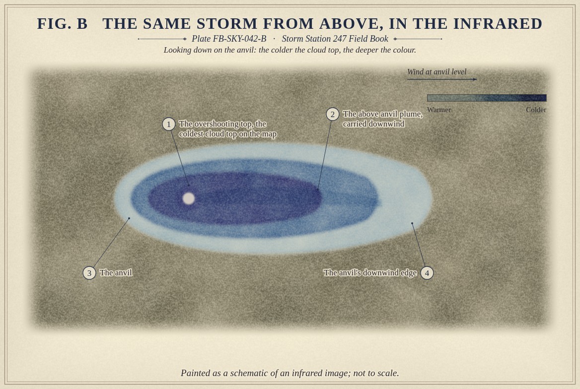
Downwind of the dome, ice thrown higher still can be caught by the wind above the anvil and stream away from it as a plume, the above anvil plume. Both mark the strongest storms, and both are watched from space.
What it is not
It is not the anvil itself, which is flat and spreads along the tropopause; the dome stands above it, over the updraft. It is not the cauliflower top of a growing cumulus, Cumulus FB-SKY-018, which lies below the tropopause. And it is not permanent: a single dome rises and collapses in minutes, and a storm with a strong, lasting updraft sends up one after another.
Lookalikes
- Anvil
- Flat, spreading along the tropopause; the dome stands above it
- Cumulus congestus top
- A cauliflower top below the tropopause, not a dome above an anvil
- Gravity wave ripples
- Waves on the anvil top that move away from the dome; the dome itself stands over the updraft
The machine
Above the tropopause the air grows warmer with height, Atmosphere in section FB-ENG-001. A parcel carried up into it by the updraft keeps cooling as it rises, so it is soon much colder than the air around it, and heavier. It slows, stops and falls back. That is why the dome is the coldest cloud top on the map: it is the one place where cloud has been pushed up into air it cannot stay in, still carrying the cold of its rise.
How high the dome rises measures how strongly the updraft is still rising at the tropopause. A few thousand feet is usual; much more than about 10,000 ft (3 km) is rare. A storm whose tops repeatedly overshoot has an updraft strong enough to hold large hail aloft and to feed a mesocyclone, Supercell FB-EVT-007, and such storms bring most of the damaging hail, wind and tornadoes.
The plume forms where the dome's ice is thrown into the stratosphere and the wind there, strong and often from a different direction than the wind at anvil level, carries it downwind above the anvil. Because the stratosphere is warmer than the anvil top, the plume can look warmer than the anvil beneath it on an infrared image.
The drawings
Each figure drawn as an engineering sheet, its parts numbered, to print at 11 by 17.
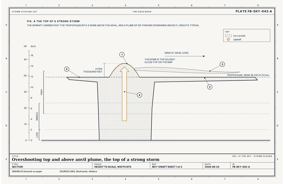
- The overshooting top
- The anvil
- The above anvil plume
- The updraft
- The tropopause
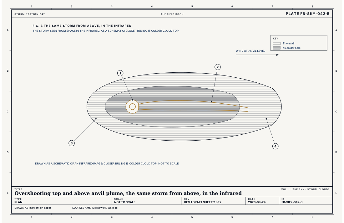
- The overshooting top, the coldest cloud top on the map
- The above anvil plume, carried downwind
- The anvil
- The anvil's downwind edge
Ingredients
- An updraft strong enough that its air, reaching the tropopause, is still rising fast
- Its momentum, which carries the air past the level where it stops being buoyant
- Strong wind above the anvil, which carries ice from the dome downwind as a plume
Scales
- time
- minutes for one dome; they pulse and collapse and rise again while the updraft lasts
- horizontal
- a dome a mile or a few miles (a few km) across; a plume can stream 100 mi (160 km) downwind
- vertical
- a few thousand feet above the anvil
- orlanski
- meso gamma
Signatures
- satellite
- the coldest cloud tops on the infrared image, often in a V or U shaped ring of cold cloud; bubbling texture and shadows in the visible
- radar
- a strong, tall echo reaching above the tropopause
- surface
- none directly: it stands far above any station, though the storm beneath it often brings hail and damaging wind
The numbers
| Quantity | Value, and the kind of number it is |
|---|---|
| Overshooting top | A dome of cloud above the anvil, made by an updraft that carries air past the tropopauseStandard, Glossary of Meteorology |
| Height above the anvil | Typically a few thousand feet, rarely more than about 10,000 ft (3 km)Typical, Markowski 2010 |
| Temperature | Colder than the anvil around it, because the rising air keeps cooling as it overshootsTextbook, Wallace 2006 |
| Tropopause | 36,000 ft (11 km) in the standard atmosphere; near 39,000 ft (12 km) above summer stormsStandard, U.S. Standard Atmosphere |
| Above anvil plume | Ice thrown into the lower stratosphere above the anvil and carried downwindTextbook, Markowski 2010 |
| Severe thunderstorm | Hail of 1 inch (2.5 cm) or more, a gust of 58 mph (50 knots, 26 m/s) or more, or a tornadoStandard, Directive 10-511 |
How the station sees it
No station on the ground sees it: the dome stands far above every instrument. Satellites see it best. In the infrared, Fig. B, it is the coldest spot on the storm's top, often at the upwind end of a V or U shaped ring of cold cloud, with the plume spreading downwind from it. In the visible, the dome casts a shadow on the anvil in the low sun of morning and evening, and its top bubbles as each new pulse arrives. Radar sees the storm's echo reaching unusually high.
- The radar on the live map: the rain and hail falling from the storm, every few minutes
How it is warned
The dome is not warned; the storm beneath it is. Forecasters use overshooting tops, and above anvil plumes, as signs that a storm's updraft is strong enough to be severe, and they watch for them on the satellite loop while the radar shows what is happening lower down. The warnings that follow are Severe Thunderstorm and Tornado Warnings, Thunderstorm FB-EVT-001.
See also
- Cumulonimbus FB-SKY-019
- Cumulonimbus architecture FB-SKY-041
- Atmosphere in section FB-ENG-001
- Thunderstorm FB-EVT-001
- Supercell FB-EVT-007
Sources
- American Meteorological Society. Glossary of Meteorology.
- Markowski, P. and Y. Richardson. Mesoscale Meteorology in Midlatitudes (2010).
- Wallace, J. M. and P. V. Hobbs. Atmospheric Science, An Introductory Survey, 2nd ed. (2006).
- NOAA, NASA and the U.S. Air Force. U.S. Standard Atmosphere, 1976.
- National Weather Service. Directive 10-511, WFO Severe Weather Products Specification.
Definition after the International Cloud Atlas. Plate FB-SKY-042, revision 1, 2026-09-24. The number is permanent; cite it.