What it is
Cumulus is a detached cloud, dense and sharply outlined, growing upward in mounds, domes or towers whose tops look like a cauliflower. Its sunlit parts are brilliant white; its base is darker and nearly flat. It forms with its base in the low étage, Cloud classification FB-SKY-001, and the tallest grow up into the middle étage and beyond.
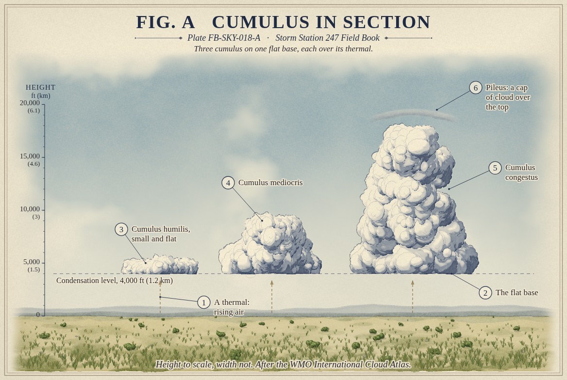
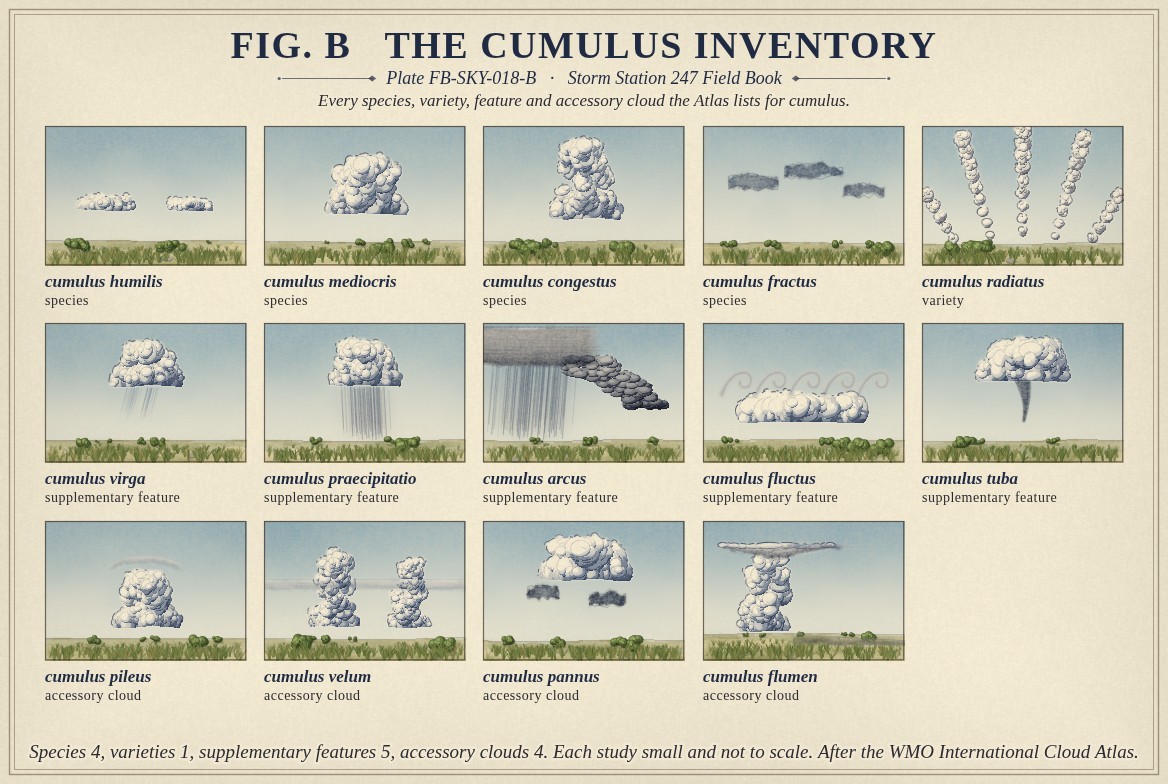
The Atlas lists four species, which are also the stages of its growth: humilis, small and flat, wider than it is tall; mediocris, about as tall as it is wide; congestus, tall and growing fast, the towering cumulus; and fractus, ragged shreds. It has one variety, radiatus, for cumulus in long rows. Five supplementary features and four accessory clouds can come with it, among them pileus, a smooth cap over a rising top, and tuba, a funnel from the base. Fig. B draws them all.
What it is not
It is not cumulonimbus, Cumulonimbus FB-SKY-019. A cumulus that makes lightning or thunder, or whose top has turned to fibrous ice, is cumulonimbus by definition; until then it is cumulus, however tall. It is not stratocumulus, Stratocumulus FB-SKY-016, which spreads sideways as a layer under a lid. It is not altocumulus castellanus, whose turrets rise from a base in the middle étage.
Lookalikes
- Stratocumulus
- A layer of joined rolls, spreading sideways under an inversion.
- Cumulonimbus
- Lightning, thunder, or a top turned to fibrous ice.
- Altocumulus castellanus
- Turrets rising from a middle level base, not from a low one.
The machine
Each cumulus stands on a thermal. The sun warms the ground, the ground warms the air above it, and a parcel of that air, warmer and lighter than the air around it, rises. As it rises it expands and cools. At the height where it has cooled to its dew point its vapour condenses, and the cloud begins: every thermal in the same air reaches its dew point at the same height, so a field of cumulus shares one flat base. Fig. A draws three on that base.
The height of the base can be estimated from the ground: about 230 ft for each °F between the temperature and the dew point (125 m for each °C). A spread of 20 °F puts the base near 4,600 ft (1.4 km).
What happens above the base depends on the air aloft. Where the air above is stable, the cloud stops as a small humilis. Where it is unstable, the rising air stays warmer than its surroundings, keeps rising, and the cloud grows to mediocris and then congestus. A rising top that pushes a moist layer above it into saturation wears a smooth cap, pileus. A congestus that keeps growing, until its top turns to ice, has become a cumulonimbus.
The drawings
Each figure drawn as an engineering sheet, its parts numbered, to print at 11 by 17.
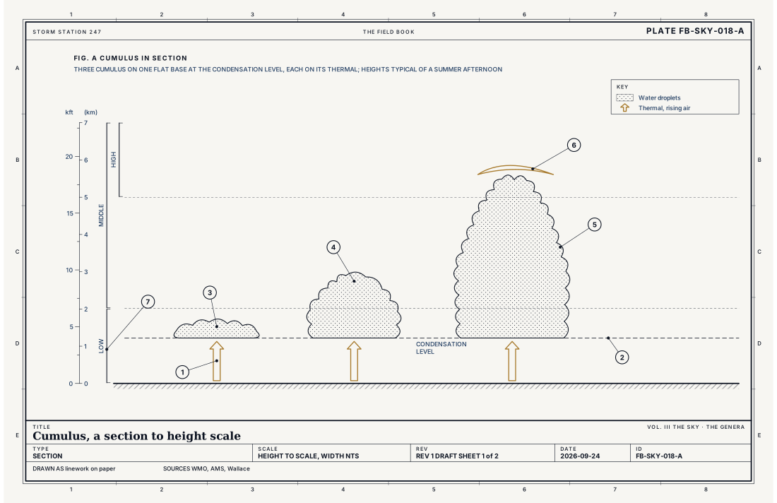
- A thermal: rising air
- The flat base at the condensation level
- Cumulus humilis
- Cumulus mediocris
- Cumulus congestus
- Pileus: a cap of cloud over the top
- The low étage
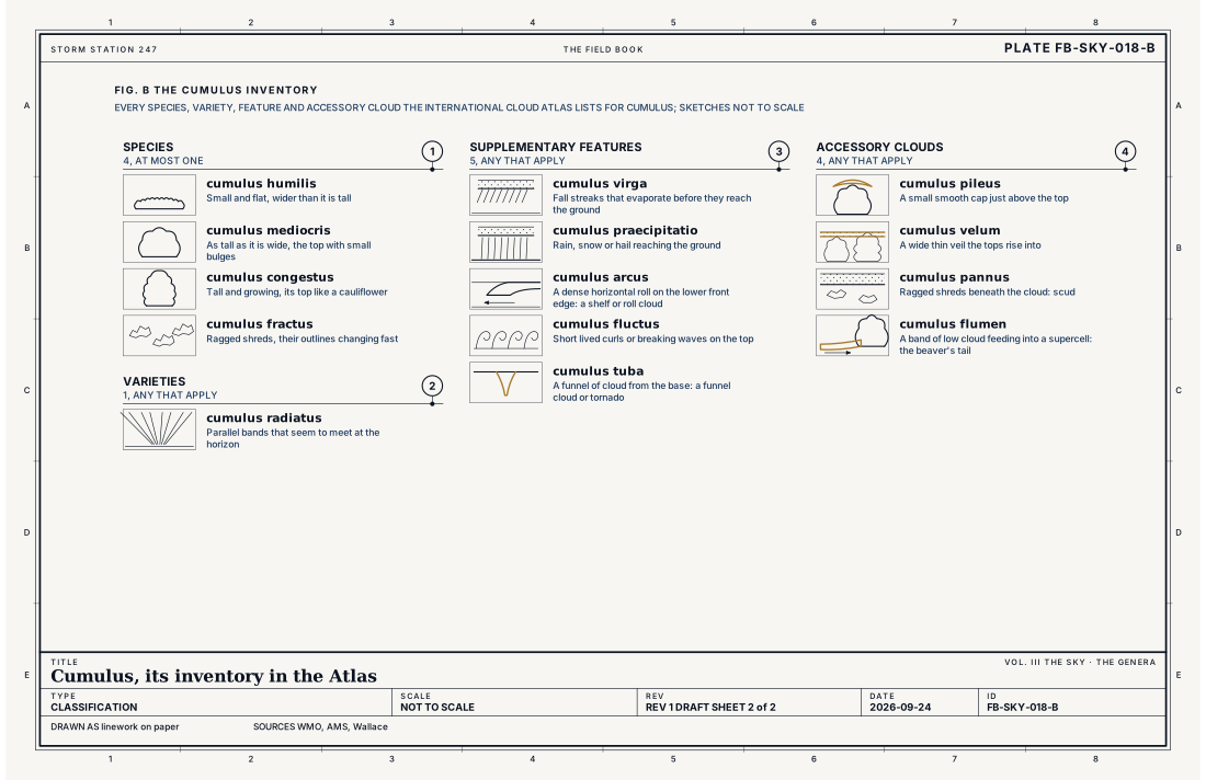
- Species, at most one
- Varieties, any that apply
- Supplementary features, any that apply
- Accessory clouds, any that apply
Ingredients
- Ground warmed by the sun, which warms the air above it
- Parcels of that air rising on their own because they are warmer than the air around them: thermals
- Enough moisture for the rising air to reach its dew point and condense
Scales
- time
- 10 to 30 minutes for one small cumulus; longer for a towering one
- horizontal
- a few hundred feet to a few miles across
- vertical
- a few hundred feet for humilis to 20,000 ft (6 km) or more for congestus
- orlanski
- meso gamma
Signatures
- surface
- scattered or broken cloud at one base height in the sky report; TCU added when towering cumulus is seen
- satellite
- bright separate cells in the visible, often in rows or streets
- radar
- no echo until the tallest begin to rain
The numbers
| Quantity | Value, and the kind of number it is |
|---|---|
| Abbreviation | CuStandard, International Cloud Atlas |
| Étage | Base in the low étage; tops can reach the middle and the highStandard, International Cloud Atlas |
| Made of | Water droplets; ice in the tops of the tallestStandard, International Cloud Atlas |
| The base | Flat, at the condensation level of the rising airTextbook, Wallace 2006 |
| Base height, estimated | About 230 ft for each °F between temperature and dew point at the ground (125 m for each °C)Textbook, Wallace 2006 |
| Species | 4: humilis, mediocris, congestus, fractusStandard, International Cloud Atlas |
| Varieties | 1: radiatusStandard, International Cloud Atlas |
| Supplementary features | 5: virga, praecipitatio, arcus, fluctus, tubaStandard, International Cloud Atlas |
| Accessory clouds | 4: pileus, velum, pannus, flumenStandard, International Cloud Atlas |
| Towering cumulus | Reported as TCU when seenStandard, Federal Meteorological Handbook No. 1 |
| Airport ceilometer | Cloud bases to 12,000 ft (3.7 km) overheadStandard, Automated Surface Observing System (ASOS) User's Guide |
How the station sees it
An airport station measures cumulus bases with the laser ceilometer, which reports scattered or broken cloud at one height: the flat base. It does not name the genus, but the observer adds TCU to the report when towering cumulus is in sight. On radar a cumulus has no echo until its drops grow large enough to fall.
- Airport weather stations: the cover and height of each layer overhead, to 12,000 ft
- The radar on the live map: the rain and hail falling from it, every few minutes
How it is warned
Cumulus is not warned. It is watched, because a congestus is a thunderstorm forming, and the warnings that follow are for the storm, Thunderstorm FB-EVT-001. A funnel from the base of a growing cumulus, tuba, is reported as a funnel cloud, and on rare occasions it reaches the ground as a tornado, Tornado FB-EVT-009.
See also
- Cloud classification FB-SKY-001
- Stratocumulus FB-SKY-016
- Cumulonimbus FB-SKY-019
- Accessory clouds FB-SKY-033
- Thunderstorm FB-EVT-001
- Tornado FB-EVT-009
Sources
- World Meteorological Organization. International Cloud Atlas.
- American Meteorological Society. Glossary of Meteorology.
- Wallace, J. M. and P. V. Hobbs. Atmospheric Science, An Introductory Survey, 2nd ed. (2006).
- Office of the Federal Coordinator for Meteorology. Federal Meteorological Handbook No. 1, Surface Weather Observations and Reports.
- National Weather Service. Automated Surface Observing System (ASOS) User's Guide.
Definition after the International Cloud Atlas. Plate FB-SKY-018, revision 1, 2026-09-24. The number is permanent; cite it.