What it is
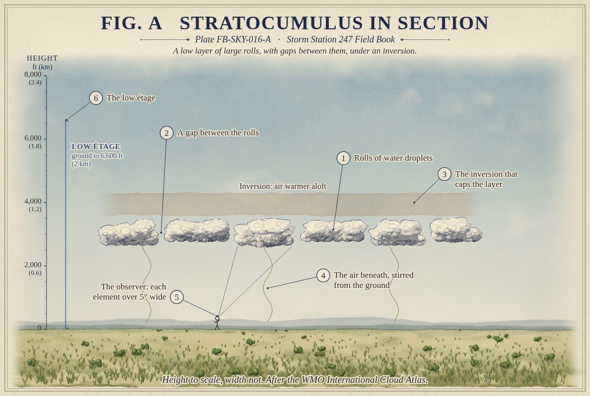
Stratocumulus is a low layer or set of patches of grey or whitish cloud, almost always with dark parts, made of rolls, lumps or rounded masses that may be joined or have gaps between them. It stands in the low étage, from the ground to 6,600 ft (2 km), Cloud classification FB-SKY-001. Seen more than 30 degrees above the horizon, most of its elements are more than five degrees wide: wider than three fingers held at arm's length.
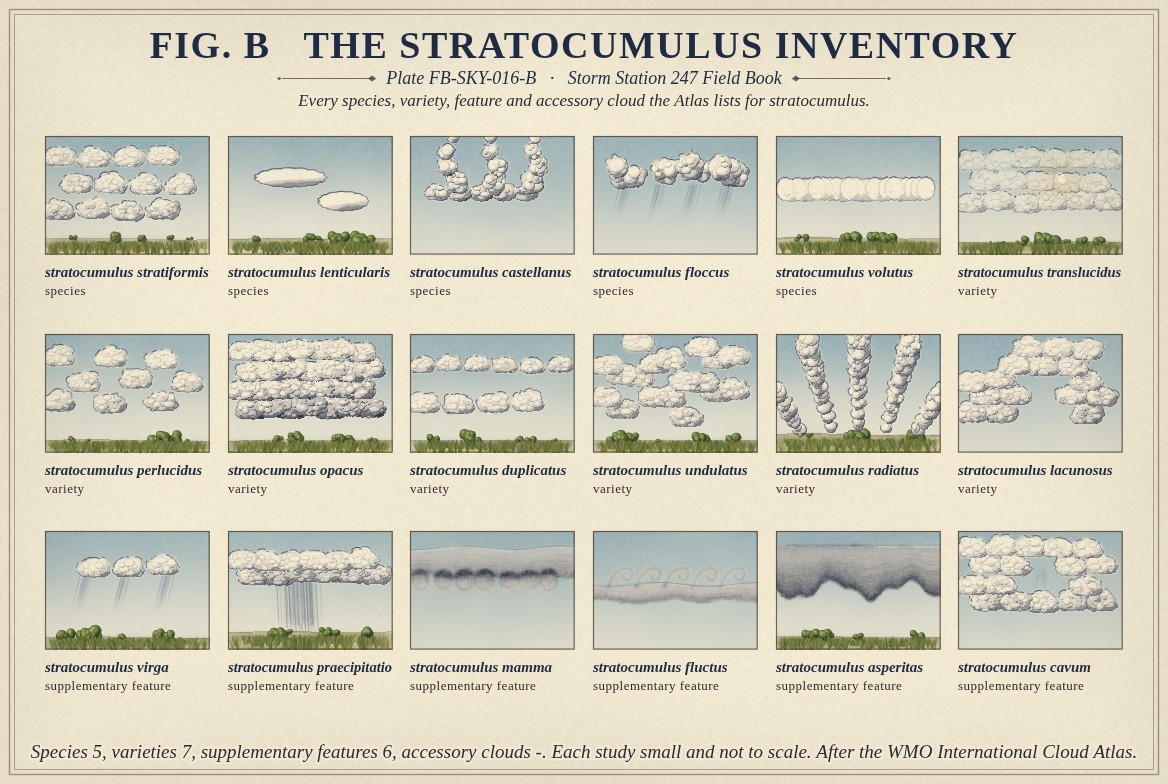
The Atlas lists the same five species for it as for altocumulus: stratiformis, lenticularis, castellanus, floccus and volutus. Seven varieties and six supplementary features can apply, from perlucidus, with sky showing between the rolls, to asperitas, a rough wave pattern on its underside. The Atlas gives it no accessory clouds. Fig. B draws every name.
What it is not
It is not altocumulus, Altocumulus FB-SKY-013, whose elements are smaller, one to five degrees wide, and stand in the middle étage. It is not stratus, Stratus FB-SKY-017, which is an even grey layer with no lumps or rolls. It is not cumulus, Cumulus FB-SKY-018: cumulus stand as separate heaps with flat bases and grow upward, where stratocumulus spreads sideways in a layer. Cumulus that spread out under a lid become stratocumulus, and the Atlas has a name for that too.
Lookalikes
- Altocumulus
- Smaller elements, 1° to 5° wide, higher.
- Stratus
- Even and featureless, with no lumps or rolls.
- Cumulus
- Separate heaps with flat bases, growing upward.
The machine
Stratocumulus lives under an inversion: a layer where the air warms with height, which stops rising air. Fig. A draws the inversion as the dense ruling above the cloud. Moist air below it is stirred upward, by the wind over rough ground or by warming from the ground or the sea below, and cools to its dew point near the top of the stirred layer. It cannot rise farther, so the cloud spreads out along the lid.
The cloud then keeps itself going. Its top radiates heat to space and cools, the cooled air sinks through the layer, and the sinking and the rising between them break the layer into cells and rolls. Where the air sinks the cloud thins into gaps; where it rises the rolls thicken. Over cool oceans off western coasts this can hold a sheet of stratocumulus in place for weeks.
Most stratocumulus gives nothing more than a grey day. A thick layer can give light drizzle, rain or snow, and its supplementary features record that: praecipitatio when it reaches the ground, virga when it does not.
The drawings
Each figure drawn as an engineering sheet, its parts numbered, to print at 11 by 17.
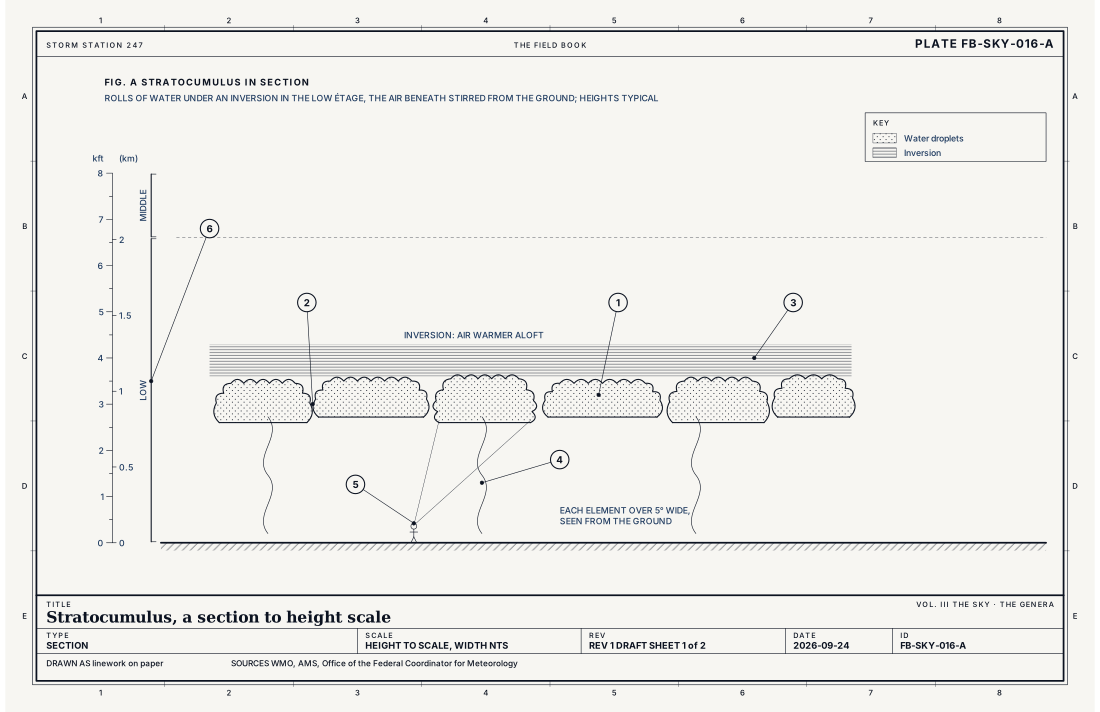
- Rolls of water droplets
- A gap between the rolls
- The inversion that caps the layer
- The air beneath, stirred from the ground
- The observer: each element over 5° wide
- The low étage
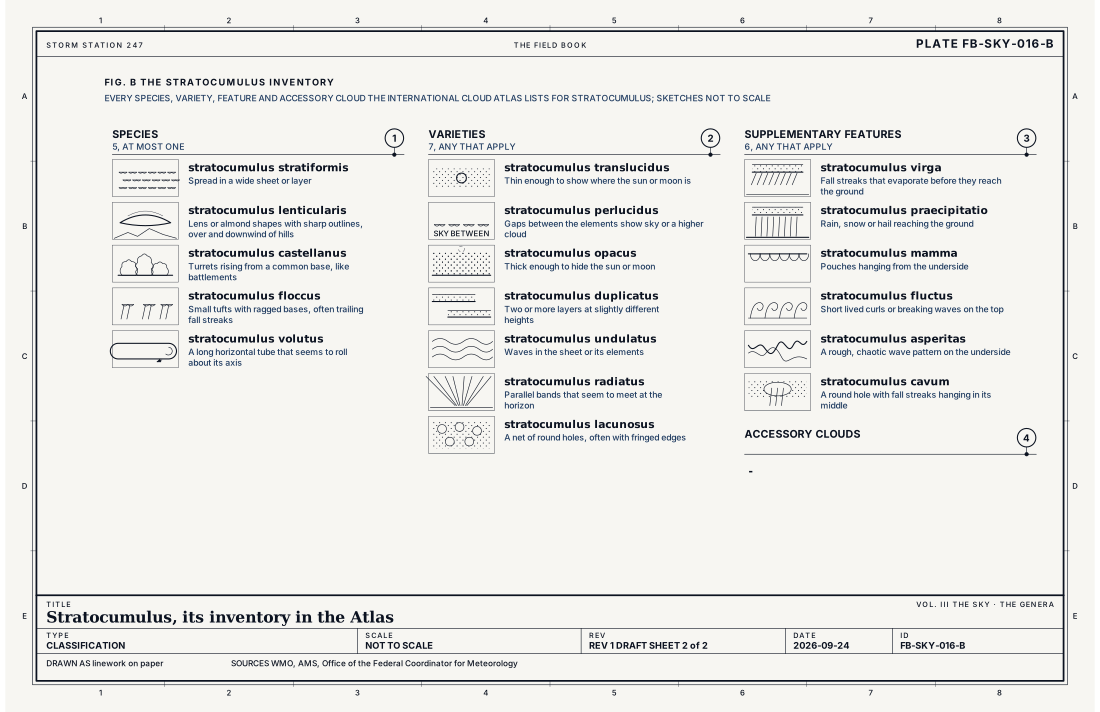
- Species, at most one
- Varieties, any that apply
- Supplementary features, any that apply
- Accessory clouds, any that apply
Ingredients
- Moist air near the ground, stirred upward by the wind or by warming from below
- An inversion above, a layer where the air warms with height, which caps the cloud
- Cooling at the cloud top, which stirs the layer from above and breaks it into cells
Scales
- time
- hours to days; over cool oceans it can last for weeks
- horizontal
- a few miles to sheets over hundreds of miles of ocean
- vertical
- about 650 to 3,300 ft (200 m to 1 km) deep, in the low étage
- orlanski
- meso and synoptic
Signatures
- surface
- a broken or overcast layer low in the sky report
- satellite
- bright in the visible, warm in the infrared; cells or rolls over the ocean
- radar
- no echo, or light drizzle
The numbers
| Quantity | Value, and the kind of number it is |
|---|---|
| Abbreviation | ScStandard, International Cloud Atlas |
| Étage | Low: from the ground to 6,600 ft (2 km)Standard, International Cloud Atlas |
| Made of | Water droplets; snow or ice crystals when very coldStandard, International Cloud Atlas |
| Element size | Most elements more than 5° wide, seen more than 30° above the horizonStandard, International Cloud Atlas |
| Species | 5: stratiformis, lenticularis, castellanus, floccus, volutusStandard, International Cloud Atlas |
| Varieties | 7: translucidus, perlucidus, opacus, duplicatus, undulatus, radiatus, lacunosusStandard, International Cloud Atlas |
| Supplementary features | 6: virga, praecipitatio, mamma, fluctus, asperitas, cavumStandard, International Cloud Atlas |
| Accessory clouds | -Standard, International Cloud Atlas |
| Airport ceilometer | Cloud bases to 12,000 ft (3.7 km) overheadStandard, Automated Surface Observing System (ASOS) User's Guide |
| Sky cover reported | In eighths of the sky: FEW 1 to 2, SCT 3 to 4, BKN 5 to 7, OVC 8Standard, Federal Meteorological Handbook No. 1 |
How the station sees it
An airport station measures stratocumulus well: it is low enough for the laser ceilometer, which reports each layer's base height and cover in eighths of the sky, FEW, SCT, BKN or OVC. A broken or overcast layer of it sets the ceiling. The station does not name the genus. Satellites show it bright in the visible images and nearly as warm as the ground in the infrared, often in rows or cells over the sea.
- Airport weather stations: the cover and height of each layer overhead, to 12,000 ft
How it is warned
Stratocumulus is not warned. It matters most to pilots, for the ceilings it sets, and to forecasters of the day's temperature: a layer that does not break keeps an afternoon several degrees cooler than a clear one, and one that breaks late surprises a forecast that expected sun.
See also
- Cloud classification FB-SKY-001
- Altocumulus FB-SKY-013
- Stratus FB-SKY-017
- Cumulus FB-SKY-018
- Drizzle FB-WAT-011
Sources
- World Meteorological Organization. International Cloud Atlas.
- American Meteorological Society. Glossary of Meteorology.
- Office of the Federal Coordinator for Meteorology. Federal Meteorological Handbook No. 1, Surface Weather Observations and Reports.
- National Weather Service. Automated Surface Observing System (ASOS) User's Guide.
Definition after the International Cloud Atlas. Plate FB-SKY-016, revision 1, 2026-09-24. The number is permanent; cite it.