What it is
A tornado is a rotating column of air in contact with the ground and hanging from a cumuliform cloud. That is the AMS Glossary's definition, and each part of it matters. The rotation must reach the ground: a funnel that hangs in the air with calm air beneath it is a funnel cloud. It must come from a cumulus or cumulonimbus: a whirl of dust on a sunny day with no cloud above it is a dust devil.
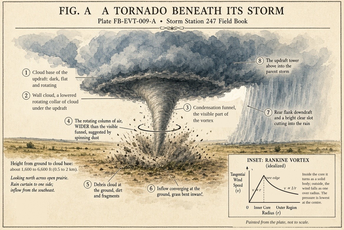
The funnel is not the tornado. The funnel is cloud condensed in the low pressure at the centre of the vortex, and it is often narrower than the winds that do the damage. Many tornadoes show no funnel at the ground at all, only a swirl of debris beneath a funnel that stops short. The rotating air is the tornado; the funnel is where it has made itself visible.
A tornado is small beside the storm that makes it. The parent supercell is tens of kilometres across; its mesocyclone a few kilometres; the tornado tens to a few hundred metres. The widest ever surveyed, at El Reno, Oklahoma, in 2013, was 2.6 mi (4.2 km) wide. Fig. A draws a tornado at its true height beneath its storm; its width is not to scale.
What it is not
It is not the storm. A supercell's mesocyclone can rotate for an hour without a tornado ever forming beneath it; most do not make one.
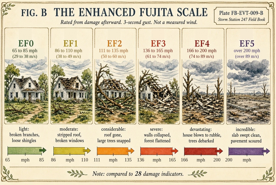
It is not measured by its wind. The Enhanced Fujita scale, drawn in Fig. B, rates a tornado from its damage after it has passed. Surveyors compare what they find against 28 kinds of structure and tree, each with its own ladder of damage, and estimate the 3 second gust that would do it. A tornado that crosses only open fields may do little rateable damage and be rated low whatever its wind. Mobile radars have measured winds near the ground of well over 224 mph (100 m s⁻¹), but the rating is still the damage.
It is not a straight line wind. Damage blown one way, trees all fallen in one direction, is a downburst's; a tornado's damage is turned and thrown from several directions, often inward toward the path.
Lookalikes
- Funnel cloud
- A rotating funnel that does not reach the ground, and whose circulation does not either. Once the circulation touches the ground it is a tornado, whether or not the funnel does.
- Gustnado
- A brief, shallow whirl along a gust front, not joined to the storm's rotation above. It can do damage. That is Gustnado FB-EVT-013.
- Scud and rain shafts
- Ragged low cloud and curtains of rain beneath a storm that look like funnels and do not rotate.
- Straight line wind
- Damage all blown one way, from a downburst, rather than turned and thrown from several directions. That is Severe wind FB-EVT-016.
The machine
There is more than one way to make a tornado, and the Book keeps them apart.
Beneath a supercell
Most strong tornadoes come from supercells, Supercell FB-EVT-007. The mesocyclone aloft is not enough by itself. Near the ground there must be rotation too, and an updraft to stretch it.
- Rotation near the ground. The storm's downdrafts, the rear flank downdraft behind the updraft and the forward flank downdraft ahead of it, spread cooler air along the ground. At their edges, where cool air meets warm, horizontal spin is made, and the downdrafts' own descent tilts some of it upright near the ground. The environment's low level shear adds its own spin.
- Stretching. The updraft above draws that rotating air upward. Where the air converges into the updraft's base and accelerates upward, the rotating column narrows and spins faster, as the vorticity equation on Supercell FB-EVT-007 says it must.
- Contraction to a tornado. In the strongest cases the rotation contracts to a column tens to hundreds of metres across, with winds of 112 to 224 mph (50 to 100 m s⁻¹) or more. The rear flank downdraft wraps around it; a clear slot of sinking, drier air appears behind it, and the wall cloud above it rotates visibly.
Whether a given supercell does this depends on details still being researched: how cold the downdrafts are (warm, moist downdrafts favour tornadoes), how strong the shear is in the lowest few hundred metres, how low the cloud base is. Forecasters use them as ingredients, not guarantees.
Without a supercell
A landspout forms when a growing cumulus updraft passes over a boundary on the ground, such as a gust front or a wind shift line, along which air is already turning. The updraft stretches that spin into a tornado without a mesocyclone above. Waterspouts over warm water form the same way. Lines of storms make tornadoes from shallow vortices along their leading edge. Each has its own plate.
Why the pressure falls
A tornado's air turns so fast and so tightly that the outward pull of the turning is balanced by the pressure alone: cyclostrophic balance, the equation below. In the simplest model, the Rankine vortex drawn in the inset of Fig. A, the air turns as a solid inside a core and falls off with distance outside it, and the pressure at the centre is lower than far away by the air's density times the square of the fastest wind. A tornado of 224 mph (100 m s⁻¹) holds a centre about 3.54 inHg (120 hPa) below its surroundings: a fall comparable to a strong hurricane's, across a few hundred metres instead of tens of kilometres.
The drawings
Each figure drawn as an engineering sheet, its parts numbered, to print at 11 by 17.
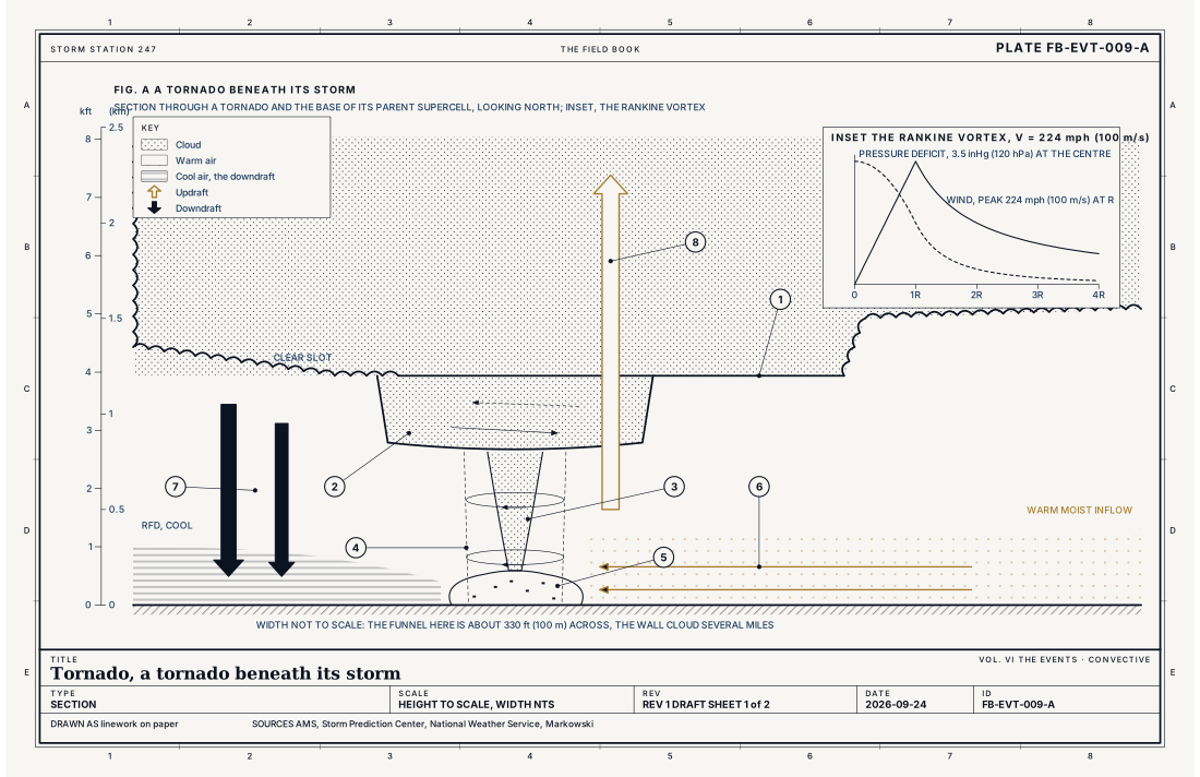
- Cloud base of the updraft
- Wall cloud
- Condensation funnel
- The rotating column, wider than the funnel
- Debris cloud
- Inflow, converging at the ground
- Rear flank downdraft and clear slot
- The updraft above
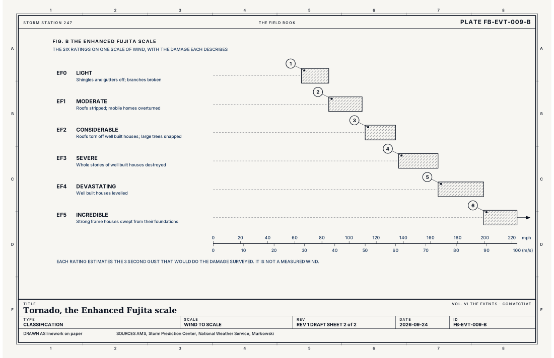
- EF0, light damage
- EF1, moderate damage
- EF2, considerable damage
- EF3, severe damage
- EF4, devastating damage
- EF5, incredible damage
Ingredients
- A parent storm with rotation near the ground: most strong tornadoes come from supercells, Supercell FB-EVT-007
- Strong low level shear and helicity in the lowest kilometre
- A low cloud base: moist air near the ground, so the downdrafts are not too cold
- Stretching: an updraft strong enough, low enough, to stretch the rotation near the ground into a narrow column
- Or, without a supercell, a boundary with spin along it stretched by a growing updraft above: the landspout path
Scales
- time
- seconds to more than an hour; most last minutes
- horizontal
- commonly tens to a few hundred metres across; the widest surveyed 2.6 mi (4.2 km)
- vertical
- from the ground to the cloud base, 1,600 to 6,600 ft (0.5 to 2 km), joined to the storm's rotation above
- orlanski
- micro-alpha to meso-gamma
Equations
Cyclostrophic balance, and the pressure in a Rankine vortex
- the wind around the vortex at radius r, m s⁻¹
- distance from the centre, m
- the density of the air, about 1.2 kg m⁻³ near the ground
- pressure, Pa
- the fastest wind, at the edge of the core
- how much lower the pressure is at the centre than far away
Assumes Cyclostrophic balance neglects the earth's rotation (the vortex is far too small and fast for it to matter) and friction. The Rankine vortex turns as a solid body inside the core and falls off as 1 over r outside it; real tornadoes are close to it above the lowest tens of metres.
Working form A tornado with a peak wind of 100 m s⁻¹ (224 mph) has a central pressure about 120 hPa lower than its surroundings; one of 50 m s⁻¹ (112 mph), about 30 hPa.
Signatures
- sounding
- strong low level shear; 0 to 3; 300 ft (0 to 1 km) helicity high; a low lifting condensation level; CAPE concentrated in the lowest 9; 800 ft (3 km)
- radar
- a tight couplet of inbound and outbound velocity at the lowest tilt, the tornadic vortex signature; a debris signature: low correlation coefficient where the reflectivity is high and the rotation strongest, the radar seeing objects that are not rain; the hook echo of the parent supercell
- satellite
- the parent storm's overshooting top; the tornado itself is far below the satellite's resolution
- surface
- a sharp pressure fall and wind shift at a station it passes near; a damage path; surveyed afterward
The numbers
| Quantity | Value, and the kind of number it is |
|---|---|
| Definition | A rotating column of air in contact with the surface, pendant from a cumuliform cloud, often visible as a funnel, as debris at the ground, or bothStandard, Glossary of Meteorology |
| EF0 | 65 to 85 mph (29 to 38 m s⁻¹), 3 second gustStandard, The Enhanced Fujita Scale (EF Scale) |
| EF1 | 86 to 110 mph (38 to 49 m s⁻¹)Standard, The Enhanced Fujita Scale (EF Scale) |
| EF2 | 111 to 135 mph (50 to 60 m s⁻¹)Standard, The Enhanced Fujita Scale (EF Scale) |
| EF3 | 136 to 165 mph (61 to 74 m s⁻¹)Standard, The Enhanced Fujita Scale (EF Scale) |
| EF4 | 166 to 200 mph (74 to 89 m s⁻¹)Standard, The Enhanced Fujita Scale (EF Scale) |
| EF5 | Over 200 mph (89 m s⁻¹)Standard, The Enhanced Fujita Scale (EF Scale) |
| How it is rated | From the damage, on 28 kinds of structure and tree, each with its own degrees of damage; not from a measured windStandard, The Enhanced Fujita Scale (EF Scale) |
| Widest surveyed | 2.6 mi (4.2 km), El Reno, Oklahoma, 31 May 2013Standard, The El Reno |
| How many | About 1,200 a year in the United States, more than anywhere elseTypical |
How the station sees it
The radar on the live map sees the parent storm: its hook echo and, near the radar, the rotation at the lowest tilt as inbound and outbound velocity side by side. Close to the radar, dual polarization sees the tornado's debris: where the reflectivity is high and the rotation strongest, the correlation coefficient falls, because leaves, insulation and pieces of buildings do not scatter like raindrops. Far from the radar the beam passes above the lowest kilometre, and a tornado can be below what it sees.
A surface station seldom sees one directly. When a tornado passes close, it records a sharp fall of pressure and a violent wind shift; a station in the path often stops reporting. What the stations and the survey teams see best is afterward: the damage path, its width and length, surveyed and rated on the EF scale.
- The radar on the live map: the parent storm's hook and, at the lowest tilt near the radar, the rotation and the debris
- Airport weather stations: a pressure fall and a wind shift, when a tornado passes close
- Road weather stations: wind along the highways, and a station's own silence when it is struck
How it is warned
A Tornado Watch is issued for several hours over a large area when the ingredients are present. A Tornado Warning is issued when radar indicates rotation that could produce a tornado, or when one is observed; its text says which, radar indicated or observed. A Tornado Emergency is issued, rarely, when a violent tornado is confirmed and is moving into a populated place.
When a warning covers you, go to the lowest floor of a sturdy building, to an interior room away from windows, and cover your head. A basement or a storm shelter is best. A mobile home or a vehicle is not shelter; leave it for a sturdy building if there is time. A highway overpass is not shelter: the wind is faster beneath it.
| VTEC | Phenomenon | The alerts that carry it |
|---|---|---|
TO | tornado | Tornado Warning; Tornado Watch |
Weather radio (SAME) codes: TOA TOR
See also
- Supercell FB-EVT-007
- Mesocyclone FB-EVT-008
- Tornado family and outbreak FB-EVT-010
- Landspout FB-EVT-011
- Waterspout FB-EVT-012
- Gustnado FB-EVT-013
- QLCS tornado FB-EVT-019
- Tornado emergency FB-EVT-172
- WSR-88D radar FB-INS-005
- How to read a warning FB-STN-001
Sources
- American Meteorological Society. Glossary of Meteorology.
- Storm Prediction Center, National Weather Service. The Enhanced Fujita Scale (EF Scale).
- Markowski, P. and Y. Richardson. Mesoscale Meteorology in Midlatitudes (2010).
- National Weather Service, Norman, Oklahoma. The El Reno, Oklahoma Tornado of May 31, 2013.
- National Weather Service. Tornado Safety.
- National Weather Service. Directive 10-511, WFO Severe Weather Products Specification.
Definition after the Glossary of Meteorology. Plate FB-EVT-009, revision 1, 2026-09-24. The number is permanent; cite it.