What it is
Cumulonimbus is the thunderstorm cloud: a heavy, dense cloud of great vertical extent, a mountain or huge tower, with a dark base in the low étage and a top that has turned smooth, fibrous or streaked with ice, and often spread out flat into an anvil. It is the one genus that spans all three étages, Cloud classification FB-SKY-001. Any cloud that makes lightning or thunder is a cumulonimbus, by the Atlas's own rule.
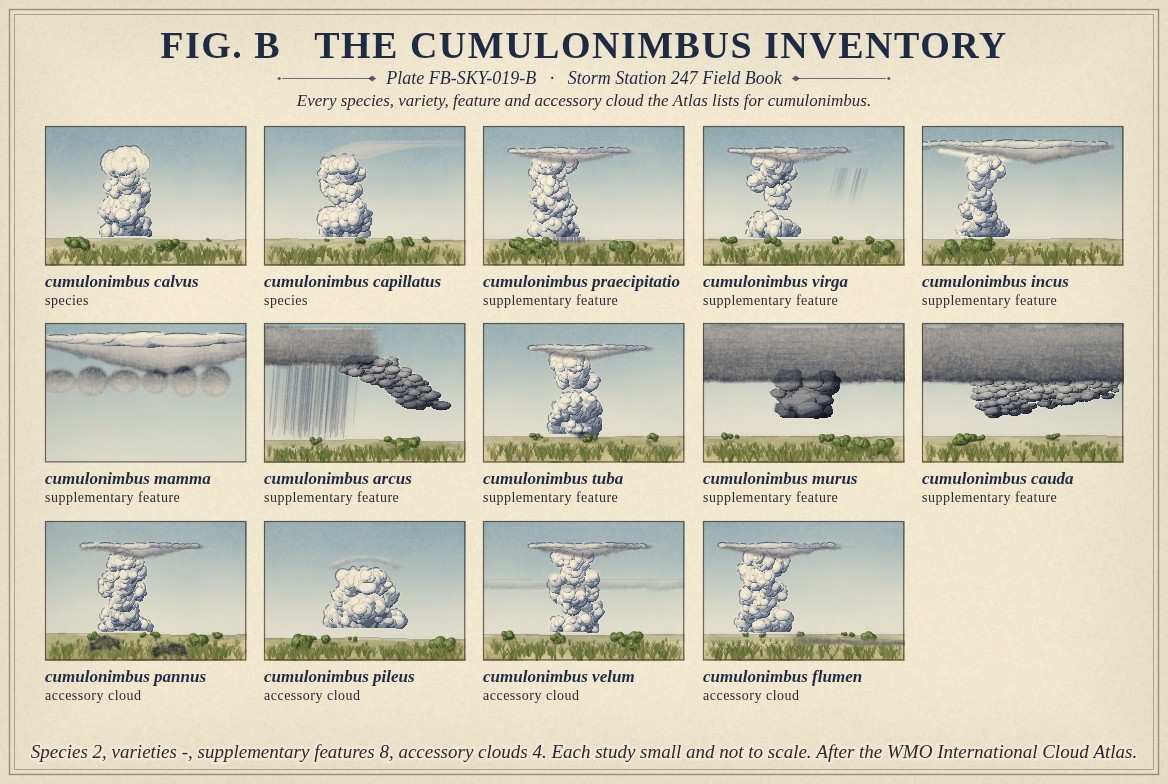
The Atlas lists two species, the two ends of its top's change to ice: calvus, the top softening and losing its cauliflower outline, and capillatus, the top plainly fibrous, often an anvil. It has no varieties. It carries more supplementary features than any other genus, eight: praecipitatio, virga, incus the anvil, mamma, arcus the shelf cloud, tuba the funnel, murus the wall cloud and cauda the tail cloud. Four accessory clouds can come with it. Fig. B draws each.
What it is not
It is not cumulus congestus, Cumulus FB-SKY-018, however tall: a congestus has a sharp cauliflower top and no ice, lightning or thunder. It is not nimbostratus, Nimbostratus FB-SKY-015, which rains steadily from a layer; a cumulonimbus rains in showers that start and stop. A thunderstorm, Thunderstorm FB-EVT-001, is the event; cumulonimbus is the cloud that makes it.
Lookalikes
- Cumulus congestus
- A cauliflower top with sharp outlines, no ice fibres and no thunder.
- Nimbostratus
- A layer with steady rain, not showers, and no thunder.
- Altocumulus castellanus
- Turrets from a middle level base, the forerunner of storms, not a storm.
The machine
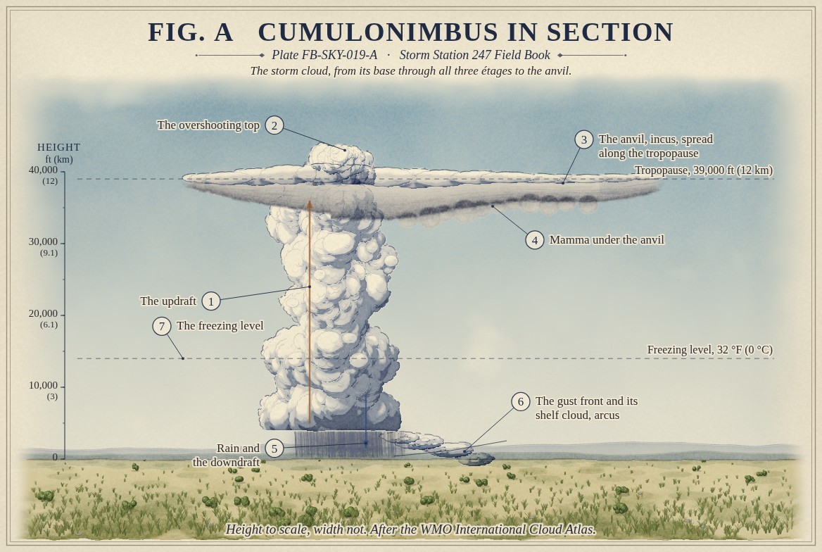
A cumulonimbus is a cumulus that kept rising. Moist air near the ground, lifted by a front, an outflow or a mountain, is warmer than the air around it all the way up through a deep unstable layer, and rises in an updraft that can exceed 60 mph (27 m/s) in a strong storm. Fig. A draws it as the hollow arrow up the tower. Above the freezing level the droplets are supercooled; ice, snow and hail grow among them, and the collisions between them separate electric charge, which is where lightning comes from.
The updraft rises until it meets the tropopause, near 39,000 ft (12 km) in the middle latitudes in summer, where the air stops cooling with height and the cloud can rise no farther. The top spreads sideways along it as the anvil, carried downwind. A strong updraft carries air on past the tropopause for a while, in a dome above the anvil: the overshooting top, Overshooting top and above anvil plume FB-SKY-042. Under the anvil, sinking air makes pouches, mamma.
Rain and hail falling through the cloud drag air down with them and cool it by evaporation; the downdraft reaches the ground and spreads out as a cold outflow. Its leading edge is the gust front, and where it lifts the warm air ahead a shelf cloud forms along it, arcus. The architecture of the cloud, and how it changes in a supercell, has a plate of its own, Cumulonimbus architecture FB-SKY-041.
The drawings
Each figure drawn as an engineering sheet, its parts numbered, to print at 11 by 17.
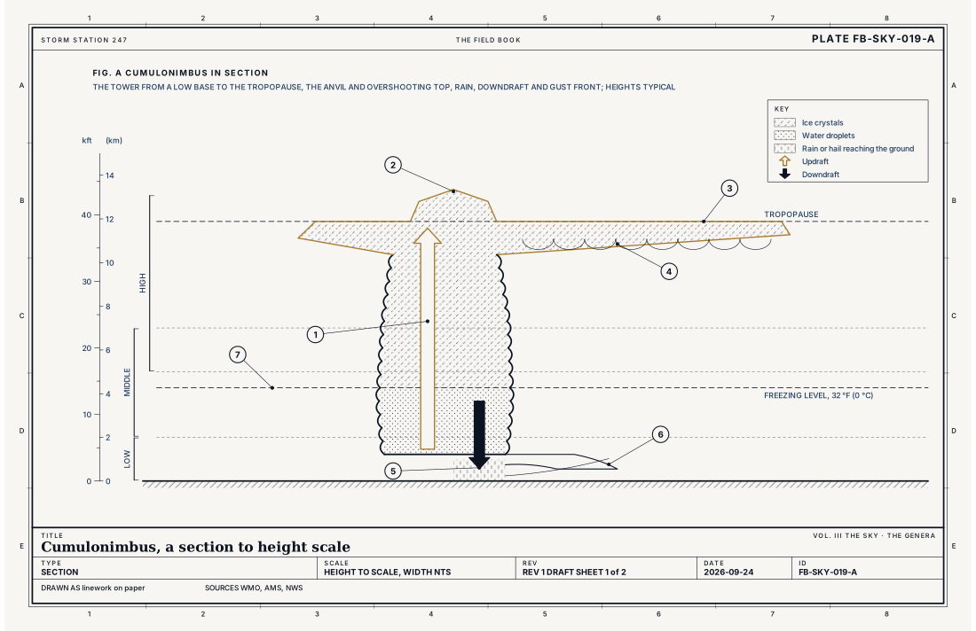
- The updraft
- The overshooting top
- The anvil, incus, spread along the tropopause
- Mamma under the anvil
- Rain and the downdraft
- The gust front and its shelf cloud, arcus
- The freezing level, 32 °F (0 °C)
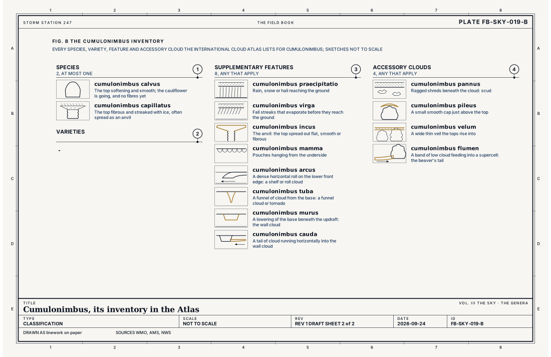
- Species, at most one
- Varieties, any that apply
- Supplementary features, any that apply
- Accessory clouds, any that apply
Ingredients
- Moist air near the ground
- An unstable atmosphere, in which rising air stays warmer than its surroundings through a deep layer
- Something to start the lift: a front, an outflow, a sea breeze or a mountain
Scales
- time
- 30 minutes to an hour for one cell; hours for a supercell
- horizontal
- 3 to 15 miles (5 to 25 km) for one tower; an anvil can spread over 60 miles (100 km)
- vertical
- from a base near 1,000 to 6,500 ft to tops of 39,000 to 60,000 ft (12 to 18 km)
- orlanski
- meso gamma to meso beta
Signatures
- surface
- CB in the sky report; thunder heard; a sharp gust, a pressure jump and a temperature drop as the outflow arrives
- satellite
- the coldest tops on the map; an anvil spreading downwind; overshooting tops as bumps above it
- radar
- strong echo from rain and hail; a hook or a rotation signature in a supercell
The numbers
| Quantity | Value, and the kind of number it is |
|---|---|
| Abbreviation | CbStandard, International Cloud Atlas |
| Étage | Base in the low étage; top usually in the highStandard, International Cloud Atlas |
| Made of | Water droplets below, supercooled droplets, ice crystals, snow and hail aboveStandard, International Cloud Atlas |
| Thunder | A cloud that makes lightning or thunder is a cumulonimbusStandard, International Cloud Atlas |
| Anvil height | Near 39,000 ft (12 km) in the middle latitudes in summer, at the tropopause; higher in the tropicsTypical, Wallace 2006 |
| Species | 2: calvus, capillatusStandard, International Cloud Atlas |
| Varieties | -Standard, International Cloud Atlas |
| Supplementary features | 8: praecipitatio, virga, incus, mamma, arcus, tuba, murus, caudaStandard, International Cloud Atlas |
| Accessory clouds | 4: pannus, pileus, velum, flumenStandard, International Cloud Atlas |
| Reported | CB added to the sky report when a cumulonimbus is seenStandard, Federal Meteorological Handbook No. 1 |
| Severe thunderstorm | Hail of 1 inch (2.5 cm) or more, a gust of 58 mph (50 knots, 26 m/s) or more, or a tornadoStandard, Directive 10-511 |
| Airport ceilometer | Cloud bases to 12,000 ft (3.7 km) overheadStandard, Automated Surface Observing System (ASOS) User's Guide |
How the station sees it
An airport station reports cumulonimbus by what it does: thunder heard, a sudden gust, a jump in pressure and a fall in temperature as the outflow arrives, heavy rain or hail. The observer adds CB to the sky report. Radar sees its rain and hail, and satellites see its top as the coldest cloud on the map, the anvil spreading and the overshooting tops as bumps above it.
- Airport weather stations: the gust, the pressure jump, the temperature drop, the rain rate and thunder heard
- The radar on the live map: the rain and hail falling from it, every few minutes
How it is warned
Every severe thunderstorm warning and nearly every tornado warning is a warning about a cumulonimbus. A storm is severe with hail of 1 inch (2.5 cm) or more, a gust of 58 mph (50 knots, 26 m/s) or more, or a tornado, Thunderstorm FB-EVT-001. The wall cloud under its updraft, Wall cloud FB-SKY-040, and a funnel from its base are what spotters report to the Weather Service, Tornado FB-EVT-009.
See also
- Cloud classification FB-SKY-001
- Cumulus FB-SKY-018
- Thunderstorm FB-EVT-001
- Supercell FB-EVT-007
- Tornado FB-EVT-009
- Wall cloud FB-SKY-040
- Cumulonimbus architecture FB-SKY-041
- Overshooting top and above anvil plume FB-SKY-042
- Lightning types FB-SKY-060
Sources
- World Meteorological Organization. International Cloud Atlas.
- American Meteorological Society. Glossary of Meteorology.
- National Weather Service. Directive 10-511, WFO Severe Weather Products Specification.
- Office of the Federal Coordinator for Meteorology. Federal Meteorological Handbook No. 1, Surface Weather Observations and Reports.
- Wallace, J. M. and P. V. Hobbs. Atmospheric Science, An Introductory Survey, 2nd ed. (2006).
- National Weather Service. Automated Surface Observing System (ASOS) User's Guide.
Definition after the International Cloud Atlas. Plate FB-SKY-019, revision 1, 2026-09-24. The number is permanent; cite it.