What it is
A hurricane is a tropical cyclone whose maximum sustained wind has reached 74 mph (33 m s⁻¹). A tropical cyclone is a low pressure system over warm tropical water, with a warm core and organized thunderstorms turning around its centre. Below hurricane strength it is a tropical depression, then a tropical storm; at 74 mph (33 m s⁻¹) it is a hurricane in the Atlantic and eastern Pacific, a typhoon in the western Pacific, and a cyclone in the Indian Ocean. It is the same machine under three names.
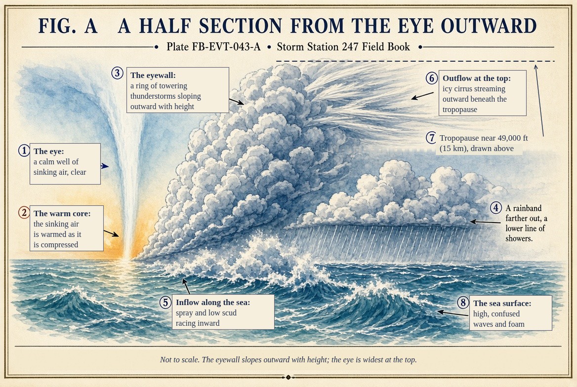
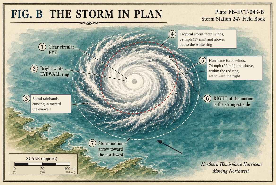
It is the largest and most organized storm on Earth. Its circulation spans 300 to 600 mi (500 to 1,000 km). At its centre is the eye, commonly 20 to 40 mi (30 to 65 km) across, often clear and calm. Around the eye stands the eyewall, a ring of towering cloud where the strongest wind and the heaviest rain are. Outside it, spiral rainbands curl inward across hundreds of kilometres.
What it is not
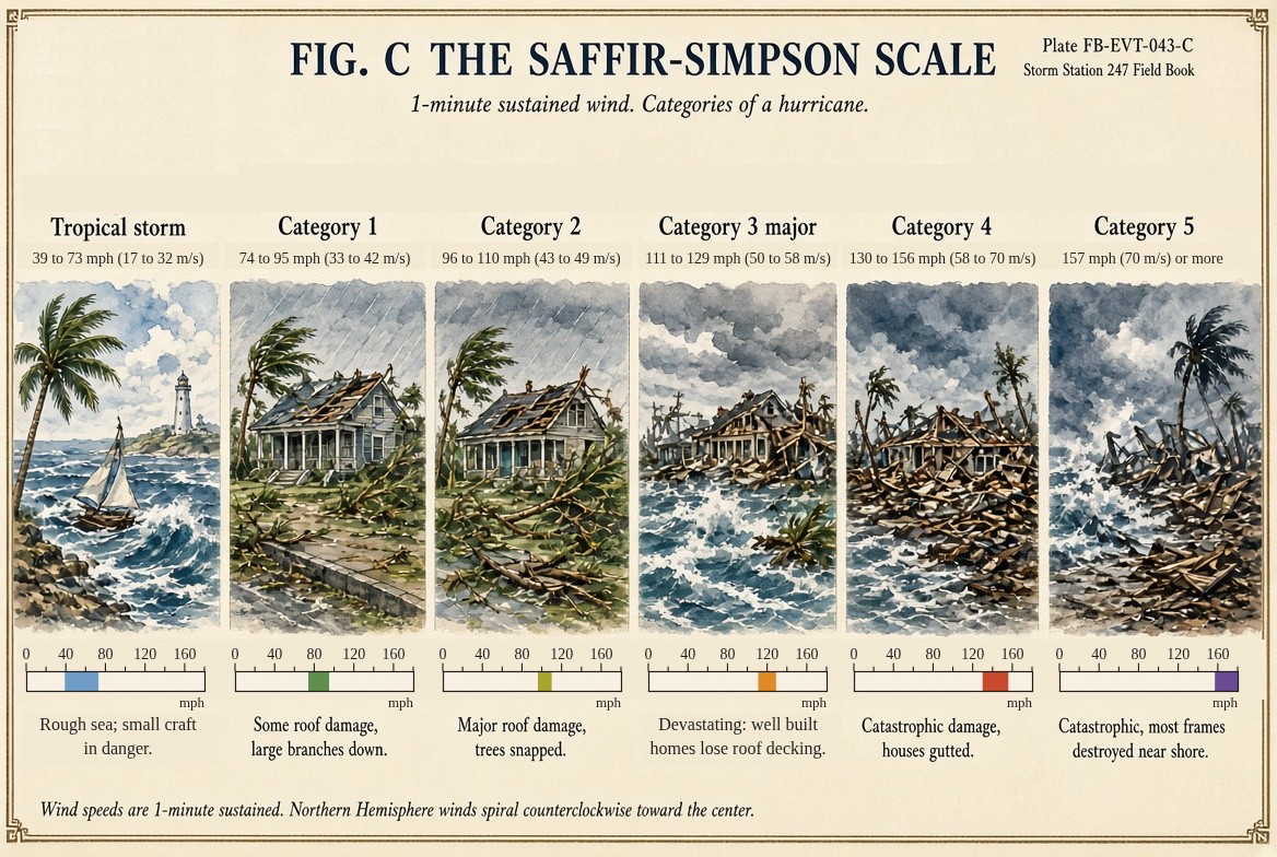
It is not only a wind storm. The Saffir-Simpson scale, drawn in Fig. C, rates a hurricane by its sustained wind and nothing else, and a low category says nothing about the water. Of the people killed in the United States by Atlantic tropical cyclones from 1963 to 2012, about nine in ten were killed by water: about half by storm surge, about a quarter by flooding rain. Weak, slow hurricanes and tropical storms have caused some of the worst floods.
It is not a midlatitude cyclone. A nor'easter draws its energy from the contrast between cold and warm air masses and has a cold core. A hurricane draws it from a warm ocean and has a warm core; it needs no fronts, and it weakens when it meets them.
The forecast cone is not the storm. It is where the centre is likely to go, and the centre stays inside it about two thirds of the time. The wind, rain and surge reach far outside it.
Lookalikes
- Tropical storm
- The same machine, weaker: sustained wind of 39 to 73 mph (17 to 32 m s⁻¹). It can flood as badly as a hurricane. That is Tropical storm FB-EVT-042.
- Nor'easter
- A cyclone of the middle latitudes, cold at its core and fed by the contrast between air masses, not by a warm sea. That is Nor'easter FB-EVT-066.
- Extratropical transition
- A hurricane turning into a midlatitude cyclone as it moves north, often growing larger as it does. That is Extratropical transition FB-EVT-050.
The machine
A hurricane is a heat engine, and the ocean is its fuel.
- Inflow. Air spirals inward toward the centre along the sea surface, slowed by friction so that it crosses the circles of the wind toward the low. As it goes it takes up heat and water vapour from a sea warmer than about 80 °F (26.5 °C).
- Ascent. At the eyewall the moist air rises. As it condenses, its latent heat warms the column. The eyewall slopes outward with height, as Fig. A draws it.
- Outflow. At the top of the troposphere, near 49,000 ft (15 km), the air spreads outward and turns the other way, anticyclonically, before it sinks far from the centre and returns.
- The warm core. Air sinking in the eye is compressed and warmed. The whole centre of the storm is warmer than its surroundings at every level, so the pressure at the sea surface beneath it is low, and the wind turns around that low in balance with it.
- Feedback. Lower pressure at the centre draws the inflow faster; faster wind over the sea takes up more heat; more heat released in the eyewall lowers the pressure further. That feedback is why a hurricane can intensify rapidly over very warm water.
The engine has a ceiling. Treated as a Carnot engine, taking in heat at the sea surface temperature and giving it up at the cold outflow temperature near the tropopause, a hurricane has a potential intensity that depends on how warm the sea is, how cold the outflow is, and how far the air above the sea is from saturation. The equation is below. Most storms never reach it: vertical wind shear tilts the storm and blows its heat away from the centre, dry air entrained into the core weakens the convection, and the storm's own wind churns cooler water up from beneath the surface.
As a hurricane strengthens, its eyewall often contracts, and then a new eyewall forms outside the old one and replaces it; the storm weakens for a time and may grow larger. That is the eyewall replacement cycle, Eyewall replacement FB-EVT-046.
Why the right side is worse
A hurricane moves, commonly at 10 to 20 mph (5 to 10 m s⁻¹). On the side where its motion adds to its spin, the right side of its track in the Northern Hemisphere, the wind is stronger; on the left it is weaker. Fig. B draws the wind field in plan, larger on the right. The right front of a landfalling hurricane also brings the highest surge, because the wind there blows toward the shore.
The drawings
Each figure drawn as an engineering sheet, its parts numbered, to print at 11 by 17.
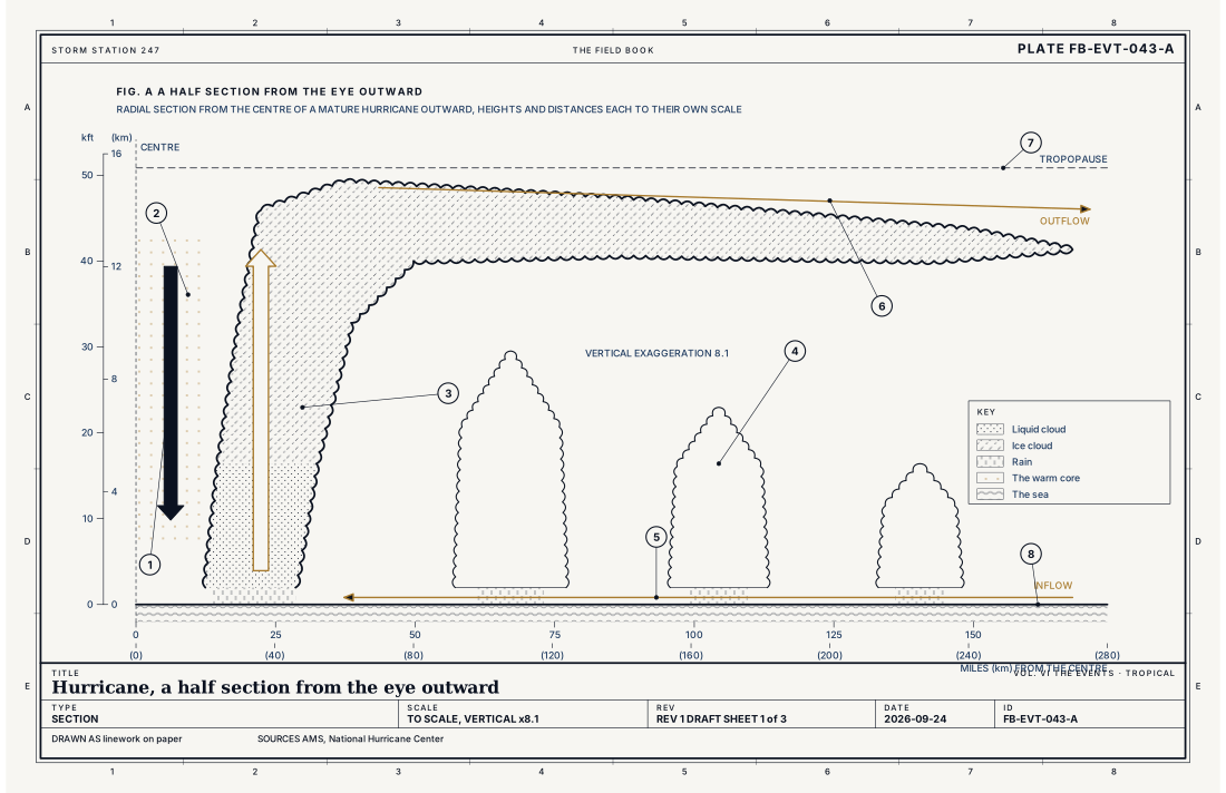
- The eye, air sinking
- The warm core
- The eyewall, sloping outward
- A rainband
- Inflow along the sea
- Outflow at the top
- The tropopause
- The sea surface
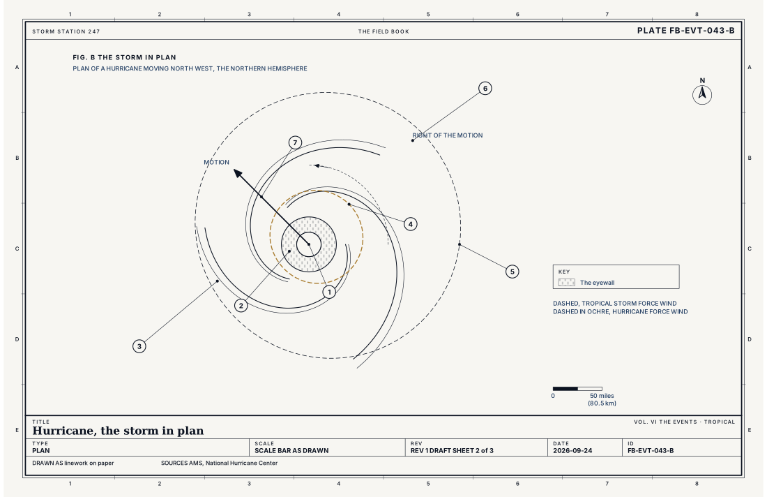
- The eye
- The eyewall
- Spiral rainbands
- Hurricane force wind, 74 mph (33 m s⁻¹) or more
- Tropical storm force wind, 39 mph (17 m s⁻¹) or more
- The right of the motion, the strongest side
- The storm's motion
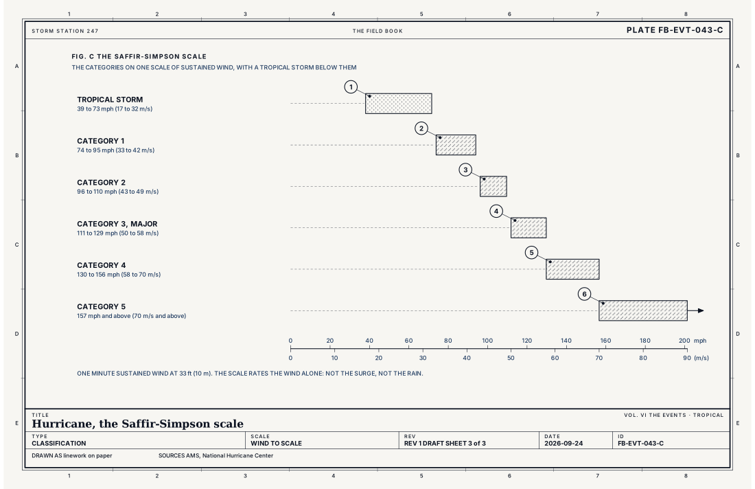
- Tropical storm
- Category 1
- Category 2
- Category 3, major
- Category 4
- Category 5
Ingredients
- Warm ocean: about 80 °F (26.5 °C) or warmer, through the top 160 ft (50 m) or so
- Moist air through the middle troposphere
- Weak vertical wind shear, so the storm's heat is not blown off its centre
- Distance from the equator, 5° of latitude or more, so the earth's rotation can spin it
- A disturbance to start from: a tropical wave, or the tail of an old front
Scales
- time
- days to about two weeks, as a tropical cyclone
- horizontal
- the eye 20 to 40 mi (30 to 65 km) across; hurricane force winds to 30 to 90 mi (50 to 150 km) from the centre; the circulation 300 to 600 mi (500 to 1,000 km)
- vertical
- the whole tropical troposphere, to about 49,000 to 52,000 ft (15 to 16 km)
- orlanski
- meso-alpha to synoptic
Equations
Potential intensity, the hurricane as a Carnot engine
- the greatest wind the ocean and atmosphere can sustain, m s⁻¹
- the exchange coefficients of enthalpy and of momentum at the sea surface
- the sea surface temperature, K
- the temperature of the outflow at the top of the storm, K
- the enthalpy of saturated air at the temperature of the sea surface, J kg⁻¹
- the enthalpy of the air just above the sea, J kg⁻¹
Assumes A steady, symmetric storm in balance, taking in heat at the sea surface and giving it up at the outflow temperature, as a Carnot engine does. It gives the ceiling on intensity; most storms stay well below it, held back by shear, dry air and cooler water churned up from below.
Signatures
- sounding
- a deep moist tropical column; warm to the tropopause; weak shear
- radar
- the eyewall, a ring of high reflectivity around a clear eye; spiral rainbands; in velocity, the strongest wind in the eyewall on the side where the storm's motion adds to its spin
- satellite
- a central dense overcast; a cleared eye as it strengthens; spiral bands; and cirrus outflow spreading from the top
- surface
- pressure falling hour by hour; wind rising and backing or veering as the centre passes; then a lull and a reversal in the eye
The numbers
| Quantity | Value, and the kind of number it is |
|---|---|
| Hurricane | A tropical cyclone with maximum sustained wind of 74 mph, 64 kt (33 m s⁻¹) or moreStandard, The Saffir-Simpson Hurricane Wind Scale |
| Category 1 | 74 to 95 mph (33 to 42 m s⁻¹)Standard, The Saffir-Simpson Hurricane Wind Scale |
| Category 2 | 96 to 110 mph (43 to 49 m s⁻¹)Standard, The Saffir-Simpson Hurricane Wind Scale |
| Category 3 | 111 to 129 mph (50 to 58 m s⁻¹), a major hurricaneStandard, The Saffir-Simpson Hurricane Wind Scale |
| Category 4 | 130 to 156 mph (58 to 70 m s⁻¹)Standard, The Saffir-Simpson Hurricane Wind Scale |
| Category 5 | 157 mph (70 m s⁻¹) or moreStandard, The Saffir-Simpson Hurricane Wind Scale |
| Watch and warning | A Hurricane Watch 48 hours before hurricane conditions are possible; a Hurricane Warning 36 hours before they are expectedStandard, Tropical Cyclone Watches and Warnings |
| The cone | The probable track of the centre; the centre stays inside it about two thirds of the time. It does not show the storm's sizeStandard, Definition of the NHC Track Forecast Cone |
| Eye | Commonly 20 to 40 mi (30 to 65 km) acrossTypical, Emanuel 2003 |
| Who dies | About 9 in 10 United States deaths from Atlantic tropical cyclones, 1963 to 2012, were from water: storm surge about half, rain flooding about a quarterTextbook, Rappaport 2014 |
How the station sees it
Far out at sea, a hurricane is seen by satellites and by aircraft flown into it, which measure its wind and drop instruments through it. Once it comes within about 124 to 155 mi (200 to 250 km) of the coast the radar on the live map sees its eyewall as a ring of heavy rain around a clear eye, and its rainbands spiralling in.
The tide gauges in the instrument atlas see the surge begin, hours before landfall, as the water rises above the predicted tide. The airport weather stations on the coast record the pressure falling hour by hour, the wind rising and turning, and, where the eye passes over, a sudden lull and then the wind returning from the opposite direction.
- The radar on the live map: the eyewall and the rainbands once the storm is within reach of the coast
- Tide gauges: the surge, as the water rises above the predicted tide
- Airport weather stations on the coast: the pressure falling, the wind, the rain rate
How it is warned
The National Hurricane Center issues the watches and warnings for a coast. A Hurricane Watch means hurricane conditions are possible, and is issued 48 hours before tropical storm force winds are expected, because preparations become difficult once those winds arrive. A Hurricane Warning means hurricane conditions are expected, and is issued 36 hours ahead. Tropical Storm Watches and Warnings follow the same pattern for the weaker wind. The Storm Surge Watch and Storm Surge Warning are separate, for the danger of life threatening inundation from rising water. Each local office adds a Tropical Cyclone Local Statement for its own counties.
The warnings on this site are drawn on the counties and coastal zones they cover. If you are told to evacuate from the surge, leave: run from water, hide from wind.
| VTEC | Phenomenon | The alerts that carry it |
|---|---|---|
HU | hurricane | Hurricane Warning; Hurricane Watch |
TR | tropical storm | Tropical Storm Warning; Tropical Storm Watch |
TY | typhoon | Typhoon Warning; Typhoon Watch |
Weather radio (SAME) codes: HUA HUW TRA TRW
See also
- Tropical disturbance and wave FB-EVT-040
- Tropical depression FB-EVT-041
- Tropical storm FB-EVT-042
- Major hurricane FB-EVT-044
- Eyewall replacement FB-EVT-046
- Storm surge FB-EVT-047
- Tropical rainfall flood FB-EVT-048
- Inland wind after landfall FB-EVT-049
- Coastal flood FB-EVT-105
- How to read a warning FB-STN-001
Sources
- American Meteorological Society. Glossary of Meteorology.
- National Hurricane Center. The Saffir-Simpson Hurricane Wind Scale.
- National Hurricane Center. Tropical Cyclone Watches and Warnings, product descriptions.
- National Hurricane Center. Definition of the NHC Track Forecast Cone.
- Emanuel, K. A.. Tropical Cyclones, Annual Review of Earth and Planetary Sciences 31 (2003).
- Rappaport, E. N.. Fatalities in the United States from Atlantic Tropical Cyclones, Bulletin of the American Meteorological Society 95 (2014).
- National Hurricane Center. Storm Surge Overview.
Definition after the Glossary of Meteorology. Plate FB-EVT-043, revision 1, 2026-09-24. The number is permanent; cite it.