What it is
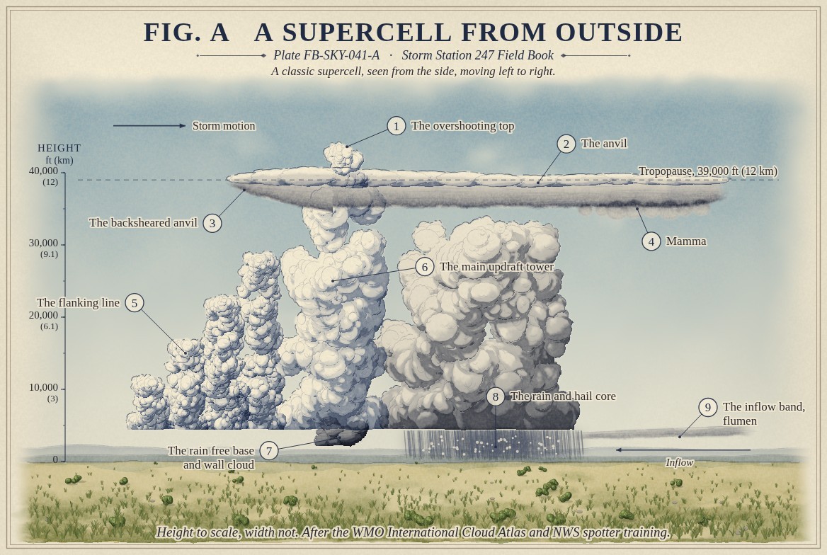
A cumulonimbus, Cumulonimbus FB-SKY-019, is one cloud built of many parts, and a storm spotter learns to name each. Fig. A draws a classic supercell side on, moving left to right, with every visible part numbered.
The main updraft rises in a tower from a flat, rain free base to the tropopause, near 39,000 ft (12 km) in the middle latitudes in summer. There its top spreads into the anvil, carried far downwind and, in a strong storm, backsheared a short way upwind against the wind aloft. Above the updraft a dome can push through the anvil: the overshooting top, Overshooting top and above anvil plume FB-SKY-042. Under the downwind anvil hang the pouches of mamma. Behind the updraft, a flanking line of towering cumulus steps up toward it, each tower a younger updraft joining the old. Under the updraft the base lowers into a wall cloud, Wall cloud FB-SKY-040; ahead of it, rain and hail fall from the forward flank; and a band of low cloud, the inflow band, can be seen feeding moist air into the storm from ahead.
What it is not
It is not a single tower. A cumulus congestus has no anvil, no ice top and no thunder. A multicell cluster has several updrafts at different stages, none lasting; a supercell has one, lasting for hours and turning, Supercell FB-EVT-007.
Lookalikes
- Cumulus congestus
- A single tower with no anvil, no ice top and no thunder
- Multicell cluster
- Several cells at different stages, none dominant, and no one lasting updraft
- Nimbostratus
- A layer with steady rain and no towers
The machine
The parts are the storm's circulation made visible. The updraft condenses its moisture into the tower and, at the tropopause, spreads it as the anvil. The downdraft beneath the rain and hail spreads out as the gust front. The wind changing with height tilts the whole storm, keeps its rain from falling back into its updraft, and in a supercell sets the updraft turning.
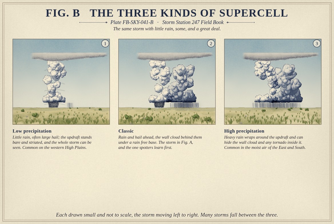
Supercells come in three kinds, drawn in Fig. B, by how much rain falls and where. A low precipitation storm drops little rain, and its bare, striated updraft stands in plain sight. A classic storm drops rain and hail ahead of the updraft, and its wall cloud hangs behind them. A high precipitation storm wraps heavy rain around its updraft and can hide the wall cloud, and a tornado, inside it.
The drawings
Each figure drawn as an engineering sheet, its parts numbered, to print at 11 by 17.
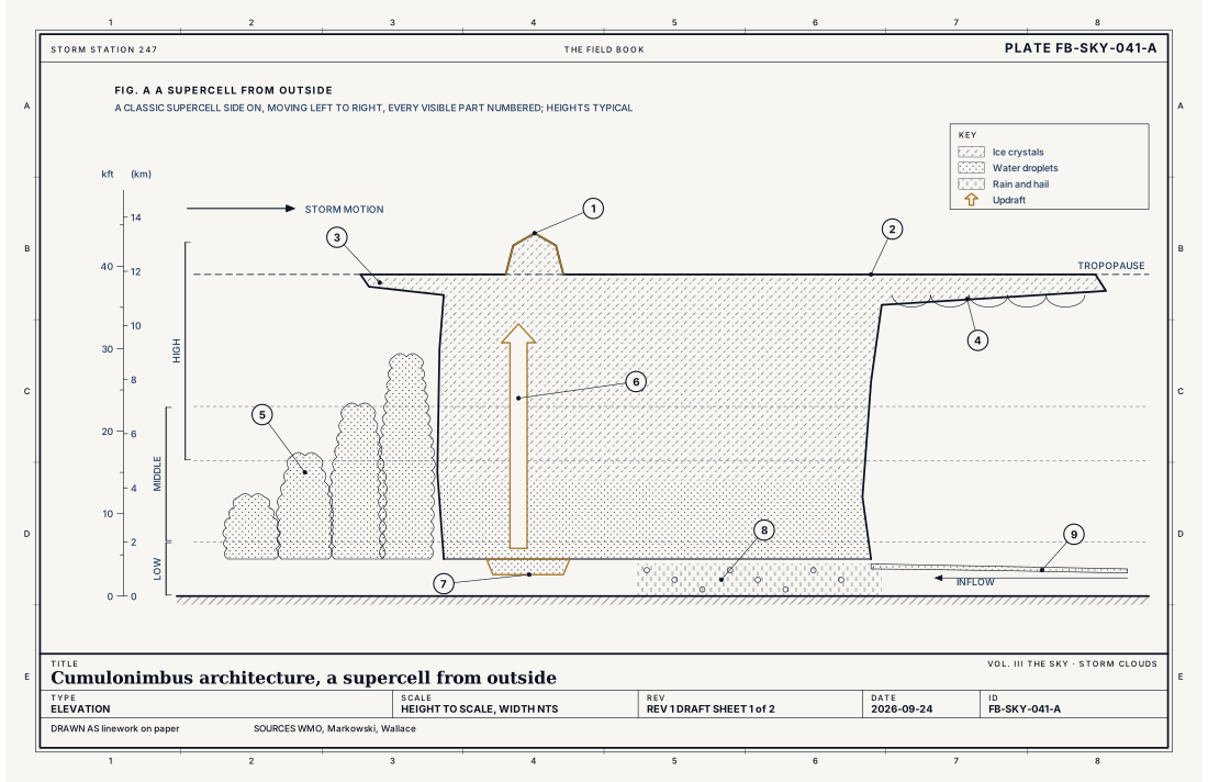
- The overshooting top
- The anvil
- The backsheared anvil
- Mamma
- The flanking line
- The main updraft tower
- The rain free base and wall cloud
- The rain and hail core
- The inflow band, flumen
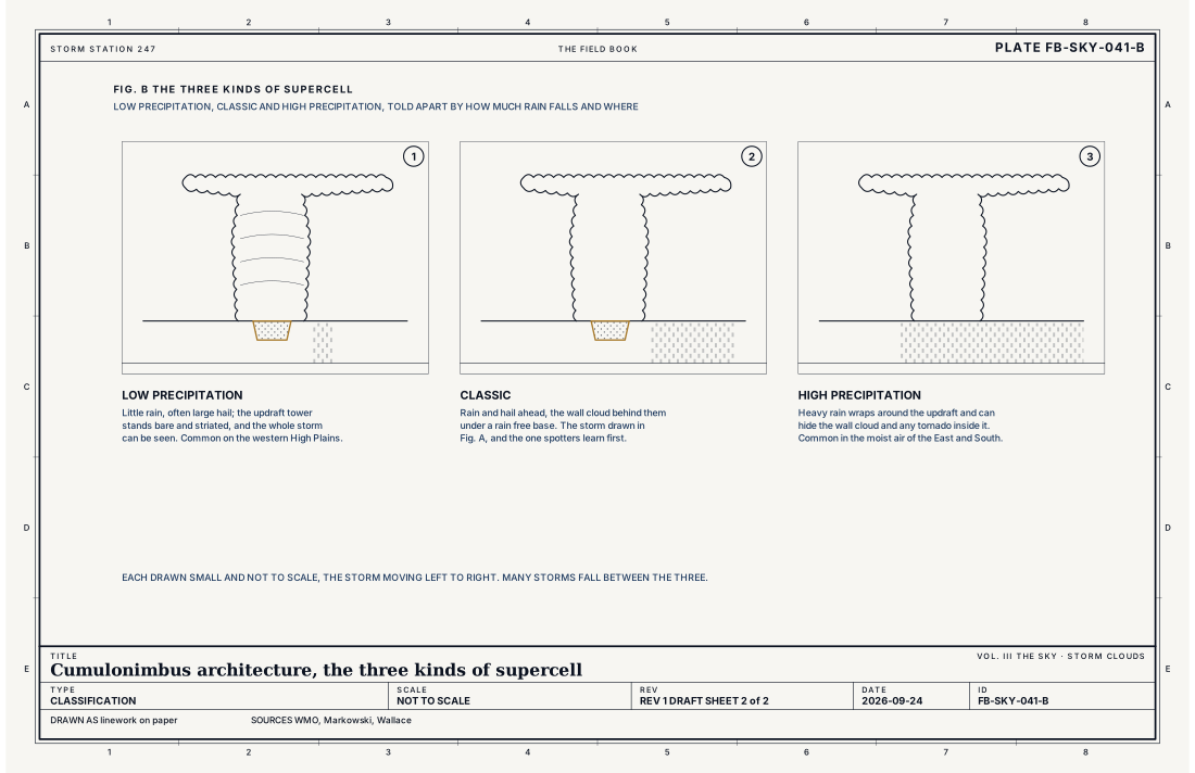
- Low precipitation
- Classic
- High precipitation
Ingredients
- A deep unstable atmosphere, so an updraft can rise to the tropopause
- Wind that changes speed and direction with height, which tilts the storm and, in a supercell, sets its updraft turning
- Moist air near the ground feeding the updraft from ahead of the storm
Scales
- time
- an hour for one cell; several hours for a supercell
- horizontal
- 10 to 30 mi (16 to 48 km) for a supercell, with an anvil that can spread over 100 mi (160 km)
- vertical
- from a base near 4,500 ft (1.4 km) to above the tropopause
- orlanski
- meso beta
Signatures
- surface
- CB in the sky report; the storm's parts are seen, not measured
- satellite
- the anvil spreading downwind, and overshooting tops above it
- radar
- the rain and hail core; in a supercell, a hook of echo round the updraft and a rotation couplet in the velocity data
The numbers
| Quantity | Value, and the kind of number it is |
|---|---|
| Anvil | Spread along the tropopause, near 39,000 ft (12 km) in the middle latitudes in summerTypical, Wallace 2006 |
| Flanking line | A line of towering cumulus stepping up toward the main updraft, usually on the storm's rear flankTextbook, Markowski 2010 |
| Backsheared anvil | Anvil spreading upwind against the wind aloft, a sign of a strong updraftTextbook, Markowski 2010 |
| Kinds of supercell | Low precipitation, classic and high precipitation, by how much rain falls and whereTextbook, Markowski 2010 |
| Atlas names | incus, mamma, murus, cauda, arcus, praecipitatio; the inflow band is the accessory cloud flumenStandard, International Cloud Atlas |
| Severe thunderstorm | Hail of 1 inch (2.5 cm) or more, a gust of 58 mph (50 knots, 26 m/s) or more, or a tornadoStandard, Directive 10-511 |
| Airport ceilometer | Cloud bases to 12,000 ft (3.7 km) overheadStandard, Automated Surface Observing System (ASOS) User's Guide |
How the station sees it
A station sees the storm by what reaches it: the gust, the pressure jump, the rain and hail, and thunder. Radar sees its rain, its hook and its rotation, and satellites its anvil and overshooting tops.
- Airport weather stations: the gust, the pressure jump, the rain rate and thunder heard
- The radar on the live map: the rain and hail falling from the storm, every few minutes
How it is warned
The Weather Service warns the storm, not its parts, Thunderstorm FB-EVT-001; spotters report the parts that radar cannot see near the ground.
See also
- Cumulonimbus FB-SKY-019
- Wall cloud FB-SKY-040
- Overshooting top and above anvil plume FB-SKY-042
- Supercell FB-EVT-007
- Thunderstorm FB-EVT-001
- Tornado FB-EVT-009
Sources
- World Meteorological Organization. International Cloud Atlas.
- Markowski, P. and Y. Richardson. Mesoscale Meteorology in Midlatitudes (2010).
- Wallace, J. M. and P. V. Hobbs. Atmospheric Science, An Introductory Survey, 2nd ed. (2006).
- National Weather Service. Directive 10-511, WFO Severe Weather Products Specification.
- National Weather Service. Automated Surface Observing System (ASOS) User's Guide.
Definition after the International Cloud Atlas. Plate FB-SKY-041, revision 1, 2026-09-24. The number is permanent; cite it.