What it is
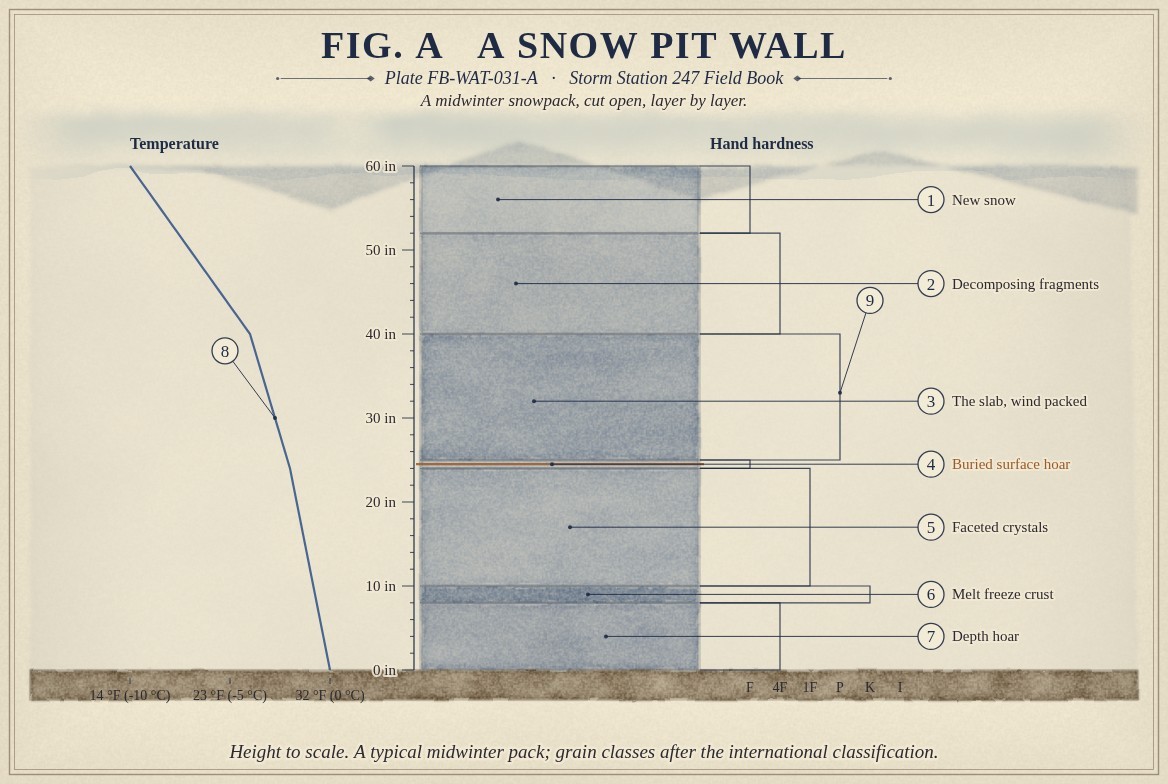
Snow that stays on the ground through a winter is not one thing. Each storm lays down its own layer, and each spell of weather between storms marks the top of the pack: a crust after sun or rain, a sparkle of hoar after a clear night, a hard slab where the wind packed it. By March a mountain snowpack is a stack of these layers, each with its own grains, density and strength. Fig. A draws one, cut open in a snow pit.
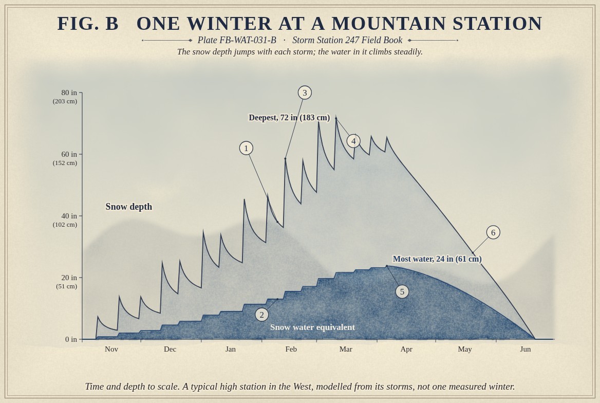
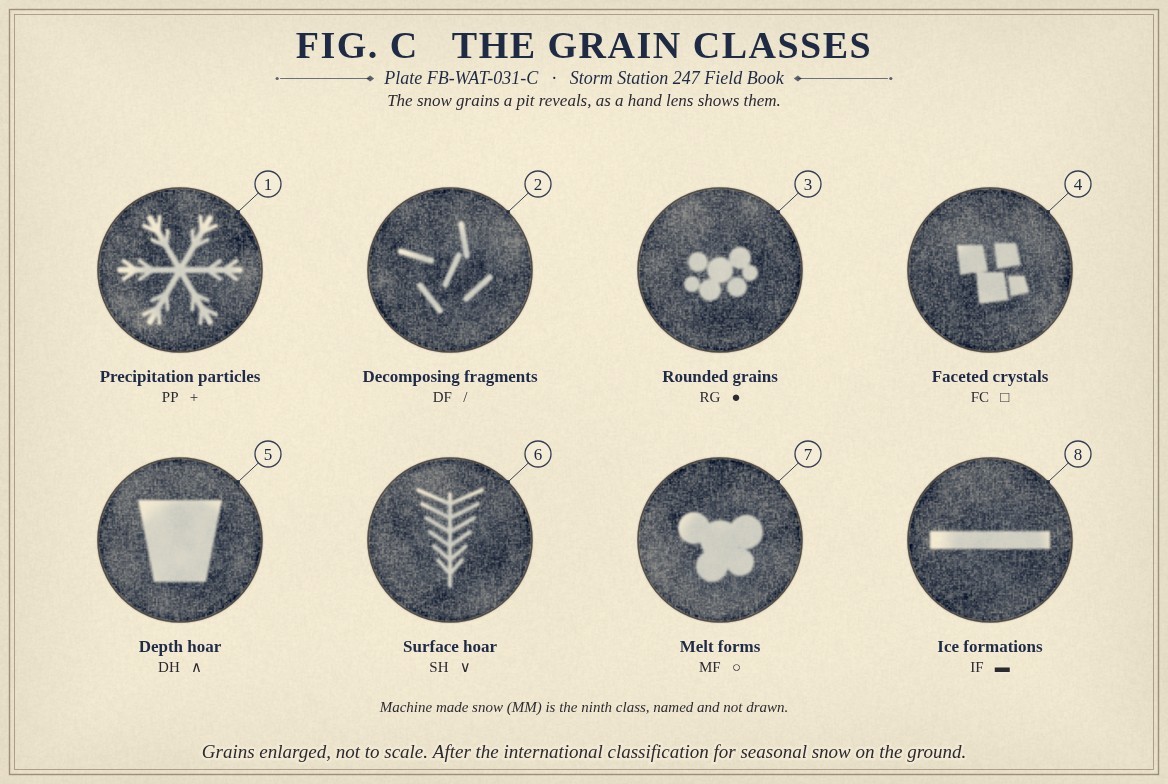
The layers do not stay as they fell. They settle, their grains change shape, and the whole pack gains water as it gains weight. Fig. B follows one winter at a mountain station, and Fig. C draws the grain types a pit reveals.
What it is not
It is not the snow depth. Depth says how deep the snow is, not how much water it holds or how its layers are built. Two packs of the same depth can hold twice the water of each other, and one can be sound while the other is ready to slide.
It is not a glacier. A seasonal snowpack melts every summer; a glacier is snow that has lasted from year to year and turned to ice.
Lookalikes
- Snow depth
- How deep the snow is. It says nothing of the water in it or of its layers; two packs of the same depth can hold very different water and very different danger.
- New snow
- What fell in the last day. It is the top layer only, the one a storm adds to the stack.
- A glacier
- Snow that has lasted from year to year and turned to ice under its own weight. A seasonal snowpack melts every summer.
The machine
Settling and rounding
New snow is mostly air, commonly about 100 kg m⁻³ (6.2 lb ft⁻³), a tenth the density of water. Under the weight of the snow above it and with time, it settles. The delicate arms of the crystals break and evaporate, the grains round, and they bond to each other where they touch. A settled layer of rounded grains is two or three times as dense as it fell, and stronger for it.
The water the pack holds is its depth times its density, divided by water's; the first equation below gives it. Forty inches of settled snow at 300 kg m⁻³ hold 12 in (30 cm) of water, the same as 120 in of new snow. That is why the water in the pack rises smoothly through a winter while the depth jumps with each storm and sinks between them.
Faceting: the gradient that weakens
The ground keeps the bottom of the pack near 32 °F (0 °C), while the surface follows the air and can be far colder. The difference drives water vapour up through the pack, from the warmer grains below to the colder ones above. Where the gradient is strong, about 5.5 °F a foot (10 °C m⁻¹) or more, the vapour builds flat faces and steps on the grains instead of rounding them. Faceted crystals bond poorly. At the base of a shallow early season pack they grow into depth hoar, large cup shaped grains that can stay weak all winter. The second equation gives the gradient: a thin pack under a cold sky facets, and the same sky over a deep pack does not.
Hoar, crusts and slabs
On a clear, calm night the snow surface cools below the air, and frost grows on it in feathers: surface hoar. Buried by the next storm intact, it is one of the most persistent weak layers there is. Sun or rain on the surface melts it, and the melt freezes into a crust. Wind picks snow up from exposed slopes and packs it onto sheltered ones as a slab, dense and cohesive.
A slab over a weak layer is the machine of a slab avalanche. The weak layer collapses or shears, the crack runs across the slope, and the whole slab slides at once.
Melt
In spring the pack warms through until the whole of it is at 32 °F (0 °C). Meltwater runs down through it, rounds the grains into clusters and refreezes at night. When the pack is saturated it releases its water to the streams, Melt and runoff FB-WAT-032.
The drawings
Each figure drawn as an engineering sheet, its parts numbered, to print at 11 by 17.
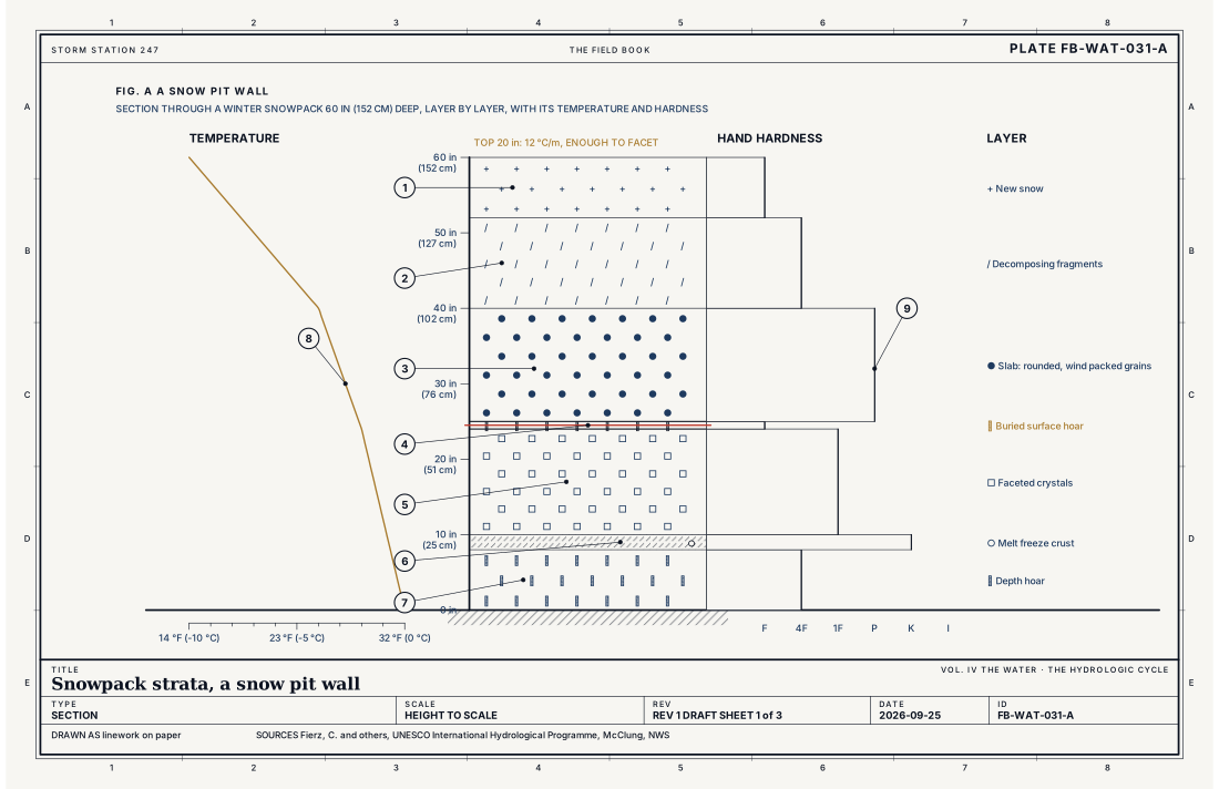
- New snow
- Decomposing fragments
- The slab, rounded wind packed grains
- Buried surface hoar, the weak layer
- Faceted crystals
- A melt freeze crust
- Depth hoar
- The temperature through the pack
- The hardness of each layer
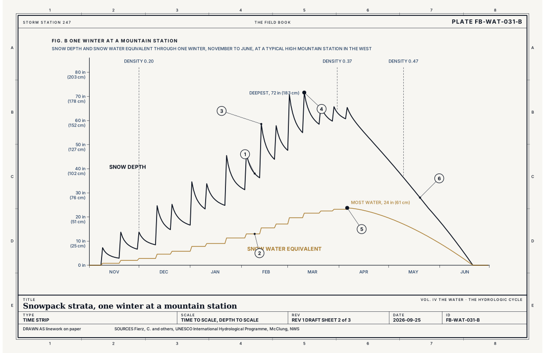
- Snow depth
- Snow water equivalent
- A storm, and the settlement after it
- The deepest snow, March
- The most water, early April
- The melt
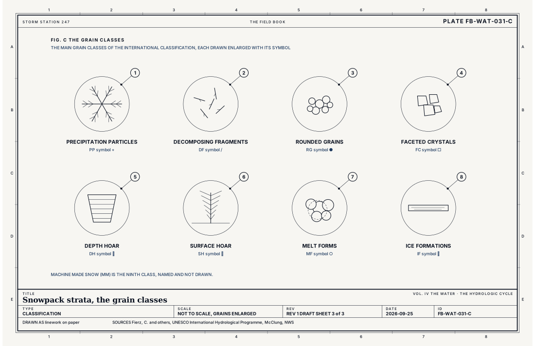
- Precipitation particles
- Decomposing fragments
- Rounded grains
- Faceted crystals
- Depth hoar
- Surface hoar
- Melt forms
- Ice formations
Ingredients
- Storms, each laying down its own layer of new snow
- The spells between storms: clear nights that grow surface hoar, sun and rain that make crusts, wind that builds slabs
- A temperature gradient through the pack, warm at the ground and cold at the surface, that drives water vapour upward
- Settlement under the weight of the snow above, which rounds and bonds the grains
Scales
- time
- a storm for a layer to fall; days to weeks for it to change; a winter for the whole stack
- horizontal
- a slope, for one layer's character; a mountain range, for the weak layers a season leaves behind
- vertical
- an inch to several feet a layer; the whole pack, a few feet to more than 10 ft (3 m)
- orlanski
- micro
Equations
Snow water equivalent
- the depth of water the snow would make if it melted, in
- the depth of the snow, in
- the density of the snow, kg m⁻³
- the density of water, 1,000 kg m⁻³
Assumes One density for the whole depth; a real pack is denser at the bottom than the top, and the equation is applied layer by layer and summed.
Working form 40 in (102 cm) of snow at 300 kg m⁻³ (18.7 lb ft⁻³) holds 12 in (30 cm) of water: the same water as 120 in (305 cm) of new snow at 100 kg m⁻³ (6.2 lb ft⁻³).
The temperature gradient
- the temperature gradient across a layer, °C m⁻¹
- the temperature at the top and the bottom of the layer, °C
- the thickness of the layer, m
Assumes A steady gradient across the layer; the rule of thumb below is for the dry snow of a cold winter pack.
Working form The ground holds the base of the pack near 32 °F (0 °C). Under a surface at 14 °F (−10 °C), a pack 20 in (51 cm) deep has a gradient of about 11 °F a foot (20 °C m⁻¹), twice the 5.5 °F a foot (10 °C m⁻¹) at which grains grow facets; a pack 60 in (152 cm) deep, under the same surface, about 3.6 °F a foot (6.6 °C m⁻¹), under it.
Signatures
- surface
- surface hoar sparkling on the snow after a clear; calm night; a crust after sun or rain; wind drifting snow off ridges onto lee slopes
- sounding
- a warm layer aloft that brings rain onto the snow; a clear; calm night that grows hoar
The numbers
| Quantity | Value, and the kind of number it is |
|---|---|
| New snow density | 50 to 150 kg m⁻³ (3 to 9 lb ft⁻³), commonly about 100 (6.2)Typical, McClung 2006 |
| Settled, rounded snow | 200 to 350 kg m⁻³ (12.5 to 21.8 lb ft⁻³)Typical, McClung 2006 |
| Spring snow, melted and refrozen | 350 to 500 kg m⁻³ (21.8 to 31.2 lb ft⁻³)Typical, McClung 2006 |
| Faceting gradient | About 5.5 °F a foot (10 °C m⁻¹) or more across a layer of dry snowTextbook, McClung 2006 |
| The grain classes | Nine: precipitation particles, machine made, decomposing fragments, rounded grains, faceted crystals, depth hoar, surface hoar, melt forms, ice formationsStandard, The International Classification for Seasonal Snow on the Ground |
| Hand hardness | Fist, four fingers, one finger, pencil, knife, ice: what can be pushed into the layer with moderate forceStandard, The International Classification for Seasonal Snow on the Ground |
| The base of the pack | Near 32 °F (0 °C), held there by the groundTypical, McClung 2006 |
How the station sees it
A station sees the pack from above and from beneath. Cooperative and volunteer observers measure snowfall and depth by hand each morning, and the water in a core of new snow. Snow pillows weigh the pack from below and report its water, SNOTEL and the snow pillow FB-INS-007. The snow tracker on snowpack.fyi reads both for the ski mountains. What no station records is the layers themselves: those come from people digging pits, and from knowing the weather each layer was made in.
- Cooperative observers: snowfall and snow depth by hand, once a day
- Volunteer rain and snow gauges: new snow, its water, and the depth on the ground, every morning
- The snow tracker on snowpack.fyi: new snow, base depth and water at sixty three mountains, from the snow pillows and the stations near them
How it is warned
Avalanche danger is forecast by avalanche centers for the mountains they cover, and the Weather Service carries their Avalanche Watch, Avalanche Warning and Avalanche Advisory to the public. The danger is rated on a five level scale, from low to extreme, by elevation and aspect. The layers drawn here are what those forecasts are about.
See also
- Snow FB-WAT-012
- Snow crystal habits FB-WAT-013
- The hydrologic cycle FB-WAT-030
- Melt and runoff FB-WAT-032
- SNOTEL and the snow pillow FB-INS-007
- Orographic lift FB-LND-001
- How to read a warning FB-STN-001
Sources
- Fierz, C. and others, UNESCO International Hydrological Programme. The International Classification for Seasonal Snow on the Ground, IHP-VII Technical Documents in Hydrology No. 83 (2009).
- McClung, D. and P. Schaerer. The Avalanche Handbook, 3rd ed. (2006).
- National Weather Service. Watch, Warning, Advisory definitions.
- American Meteorological Society. Glossary of Meteorology.
Definition after the The International Classification for Seasonal Snow on the Ground, IHP-VII Technical Documents in Hydrology No. 83 (2009). Plate FB-WAT-031, revision 1, 2026-09-25. The number is permanent; cite it.