What it is
An instrument is a sensor, set in a place, read on a clock and kept in a record. Remove any one of the four and its number cannot be trusted. A thermometer in the sun reads the sun. A gauge whose clock has drifted puts the rain in the wrong hour. A reading that was never kept cannot be checked.
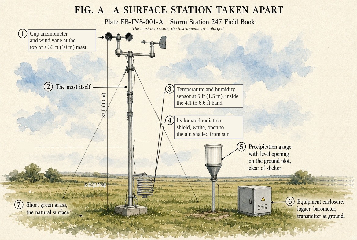
Fig. A draws a surface weather station taken apart. Each sensor stands where the WMO Guide to Instruments and Methods of Observation puts it, so that one station can be compared with another:
- Wind, at 33 ft (10 m) above open ground, high enough that the ground's roughness has less hold on it.
- Temperature and humidity, between 4.1 and 6.6 ft (1.25 and 2 m) above short grass, inside a shield that keeps the sun and the rain off the sensor and lets the air through.
- Precipitation, in a gauge with a level opening, clear of anything that could shelter it.
- Pressure, read inside the enclosure, where the pressure is the same as outside, then reduced to sea level so stations at different heights can be mapped together.
- The logger, which stamps each reading with the time in UTC, and the transmitter, which sends it on.
What it is not
It is not the weather everywhere near it. A reading describes the air at the sensor, and a station stands for the ground around it only as far as that ground is like its own. A station on a sunny airport apron and one in a shaded valley a mile away can both be right and differ by several degrees.
It is not exact. Accuracy, how close a reading is to the truth, is different from resolution, the smallest step it reports, and from drift, how its error grows with time. A thermometer that reports tenths of a degree may be accurate only to half a degree. Calibration against a reference, traceable to a national standard, is what ties a sensor to the truth.
Lookalikes
- A forecast grid point
- A number for a box of model atmosphere, not a measurement at a place. It can be close to a station's reading and still not be one.
- A radar or satellite estimate
- A remote measurement: an instrument, but one that infers the quantity at a distance, WSR-88D radar FB-INS-005.
- The analysed temperature on the live map
- An analysis: station readings joined into a surface. It is made from instruments and is not one.
The machine
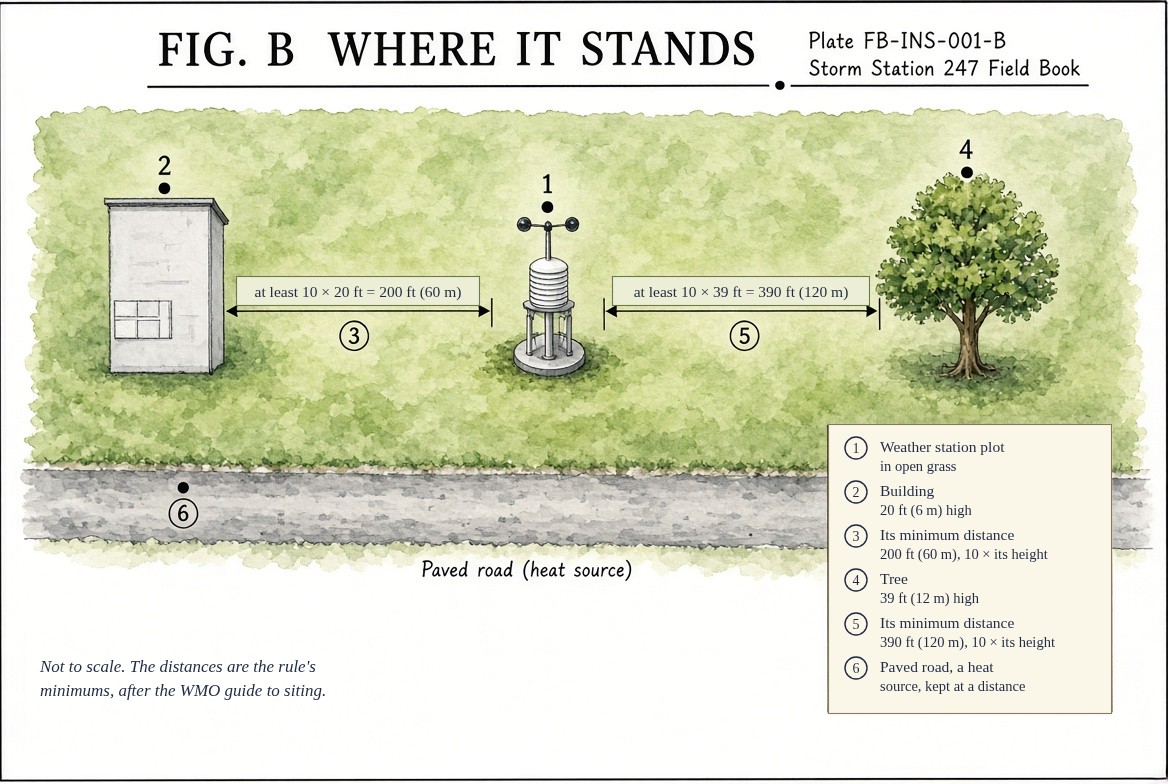
Exposure. Most of a station's error comes from where it stands, not from the sensor. A temperature sensor has to see the air and not the sun, so it sits in a louvred or aspirated shield, Stevenson screen and siting FB-INS-009. It stands over grass, because pavement heats more under the sun and gives the heat back all night. Obstacles shelter the wind for a long way downwind of them, so the Guide asks that nothing stand closer to a wind sensor than ten times its own height, Fig. B. Wind also carries drops and flakes over a gauge's opening, so every gauge catches too little in wind, and snow most of all.
Siting class. The Guide grades a site for each variable from class 1, the best, to class 5, where the surroundings can add large errors. A class describes the place, not the sensor: a perfect thermometer beside a car park is still a class 5 temperature.
Time. Every reading carries its time and its averaging. A reported wind is an average over a stated interval, two minutes in United States surface reports and ten minutes in most other countries, and a gust is the highest short burst within it. Rain is an amount over an interval. Two instruments that average differently report different numbers for the same weather, and both are right.
The drawings
Each figure drawn as an engineering sheet, its parts numbered, to print at 11 by 17.
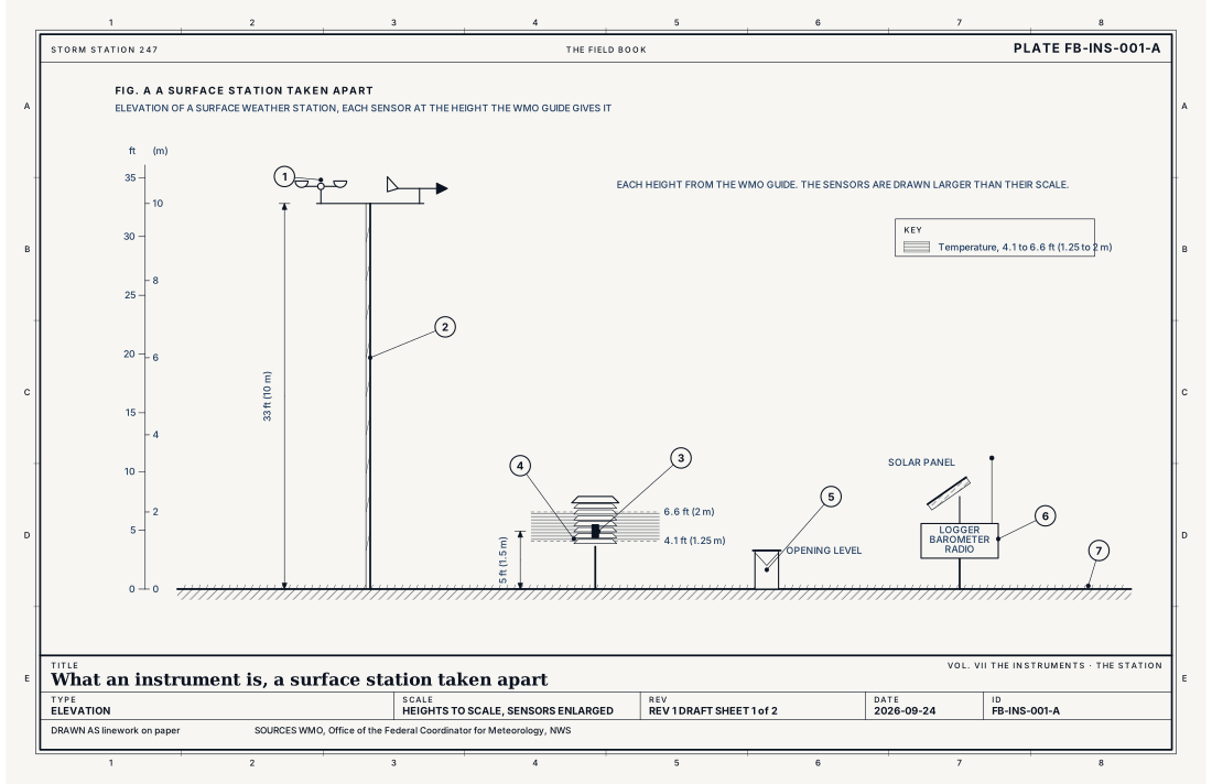
- Cup anemometer and wind vane, at 33 ft (10 m)
- The mast
- Temperature and humidity sensor
- Radiation shield, louvred and ventilated
- Precipitation gauge
- Logger, barometer and transmitter
- Short grass, the natural surface
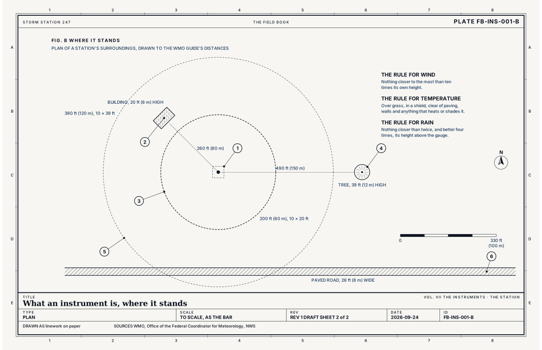
- The station plot
- A building 20 ft (6 m) high
- Ten times the building's height, 197 ft (60 m)
- A tree 39 ft (12 m) high
- Ten times the tree's height, 390 ft (120 m)
- A paved road, a source of heat
Ingredients
- A sensor, which turns a property of the air into a signal
- An exposure, the place and the housing that let the sensor read the air and nothing else
- A clock and an averaging rule, so each number means a stated interval at a stated time
- A record, kept and checked, so that the number can be traced and compared
Scales
- time
- seconds for a single sample; a two minute average for a reported wind; an hour or a day for rain
- horizontal
- the ground around the sensor, as far as that ground is like its own; a few hundred metres to a few kilometres
- vertical
- 0 to 33 ft (0 to 10 m) for a surface station
- orlanski
- micro
Signatures
- surface
- each reading with its time; its averaging interval and the station's height; a missing reading shown as missing; never filled
The numbers
| Quantity | Value, and the kind of number it is |
|---|---|
| Wind sensor height | 33 ft (10 m) above open groundStandard, Guide to Instruments and Methods of Observation (WMO-No. 8) |
| Open ground for wind | No obstacle closer than 10 times its own heightStandard, Guide to Instruments and Methods of Observation (WMO-No. 8) |
| Temperature and humidity height | 4.1 to 6.6 ft (1.25 to 2 m) above the ground, in a ventilated radiation shield, over short grass or the natural surfaceStandard, Guide to Instruments and Methods of Observation (WMO-No. 8) |
| Precipitation gauge | No obstacle closer than twice, and preferably four times, its height above the gauge's openingStandard, Guide to Instruments and Methods of Observation (WMO-No. 8) |
| Siting classes | Class 1, the best, to class 5, for each variable; the class describes the surroundings, not the sensorStandard, Guide to Instruments and Methods of Observation (WMO-No. 8) |
| Reported wind | A two minute average in United States surface reports; a ten minute average in most other countriesStandard, Federal Meteorological Handbook No. 1 |
| Time | Coordinated Universal Time (UTC)Standard, Federal Meteorological Handbook No. 1 |
| Severe wind | A measured gust of 58 mph (50 knots, 26 m/s) or moreStandard, Directive 10-511 |
How the station sees it
This is the plate behind every instrument in the atlas. Each station's page names its network, where it stands, when it last reported and its rank, which carries a date and falls when the station stops reporting. The networks are built for different jobs: airport stations to a federal standard, reporting every hour; cooperative observers reading temperature and rain once a day, some for more than a century; volunteers with rain and snow gauges; road stations sited beside the pavement, for the road. The atlas keeps them apart so each reading can be weighed for what it is.
- Airport weather stations: built and kept to a federal standard, reporting every hour and more often in changing weather
- Cooperative observers: a daily reading of temperature and precipitation, many of them with records a century long
- Volunteer rain and snow gauges: a daily reading of precipitation by hand
- Road weather stations: sited for the road, beside pavement, not for the climate
How it is warned
Instruments are not warned. They confirm a warning and score it afterwards: a measured gust of 58 mph (50 knots, 26 m/s), a report of hail an inch across, an hour of rain in a gauge. Warnings say where their evidence came from, radar indicated or observed, and a station's reading is observed.
See also
- ASOS FB-INS-002
- Personal weather station FB-INS-003
- Radiosonde FB-INS-004
- WSR-88D radar FB-INS-005
- Stevenson screen and siting FB-INS-009
- How to read a warning FB-STN-001
- Atmosphere in section FB-ENG-001
Sources
- World Meteorological Organization. Guide to Instruments and Methods of Observation (WMO-No. 8).
- Office of the Federal Coordinator for Meteorology. Federal Meteorological Handbook No. 1, Surface Weather Observations and Reports.
- National Weather Service. Automated Surface Observing System (ASOS) User's Guide.
- National Weather Service. Directive 10-511, WFO Severe Weather Products Specification.
Definition after the Guide to Instruments and Methods of Observation (WMO-No. 8). Plate FB-INS-001, revision 1, 2026-09-24. The number is permanent; cite it.