What it is
Stratus is a grey layer of cloud with a fairly even base, low over the ground, from which drizzle, snow grains or ice prisms may fall. When the sun can be seen through it, its outline is clear. It stands in the low étage, often only a few hundred feet up, Cloud classification FB-SKY-001. Stratus with its base on the ground is fog, Fog types FB-WAT-020.
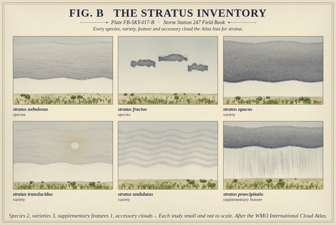
The Atlas lists two species: nebulosus, a featureless grey layer, and fractus, ragged shreds. Three varieties, opacus, translucidus and undulatus, describe a layer that hides the sun, one that shows it and one with waves. One supplementary feature, praecipitatio, records drizzle or snow reaching the ground; the Atlas gives stratus no accessory clouds. Fig. B draws each.
What it is not
It is not nimbostratus, Nimbostratus FB-SKY-015: nimbostratus is deeper and darker and gives steady rain or snow, where stratus gives drizzle. It is not stratocumulus, Stratocumulus FB-SKY-016, which has rolls and lumps and shading. It is not fog, though the only difference is height: fog is stratus on the ground, and fog that lifts becomes stratus.
Lookalikes
- Fog
- The same cloud with its base on the ground.
- Nimbostratus
- Deeper and darker, with steady rain or snow.
- Stratocumulus
- Rolls or lumps with shading, not an even base.
The machine
Stratus forms where moist air near the ground is cooled to its dew point through a shallow layer. On a clear still night the ground cools and cools the air above it; by morning a layer of cloud can lie across a valley. Moist air moving over colder ground or colder water is cooled from below in the same way, which is how sea fog and coastal stratus form. A light wind mixes the cooled air through a few hundred feet, and the cloud forms as a layer rather than at the ground.
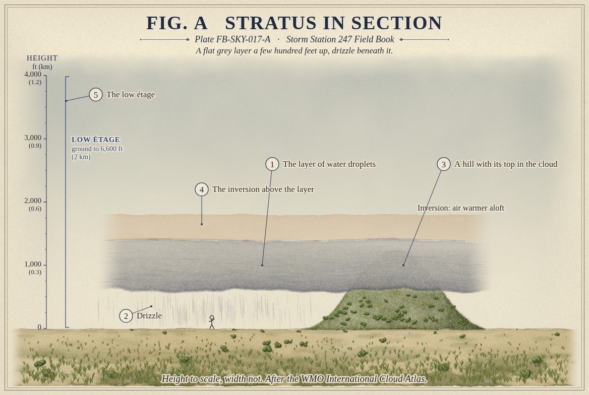
Fig. A draws what holds it there: an inversion above, a layer where the air warms with height and stops the moist air mixing upward. The cloud cannot grow up, so it stays thin and flat. The sun of the morning warms the ground under it, the air under the base warms and mixes, and the layer lifts, thins and breaks, often by midday.
Its droplets are small and many and the air in it rises slowly, so what falls is drizzle: drops too small to splash, drifting down. Where the ground rises into the layer, as the hill in Fig. A does, a hilltop is in cloud and a road over it is in fog.
The drawings
Each figure drawn as an engineering sheet, its parts numbered, to print at 11 by 17.
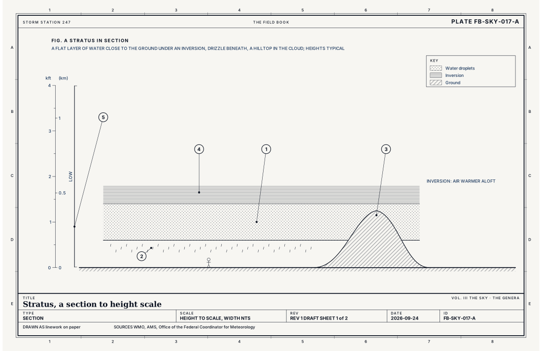
- The layer of water droplets
- Drizzle
- A hill with its top in the cloud
- The inversion above the layer
- The low étage
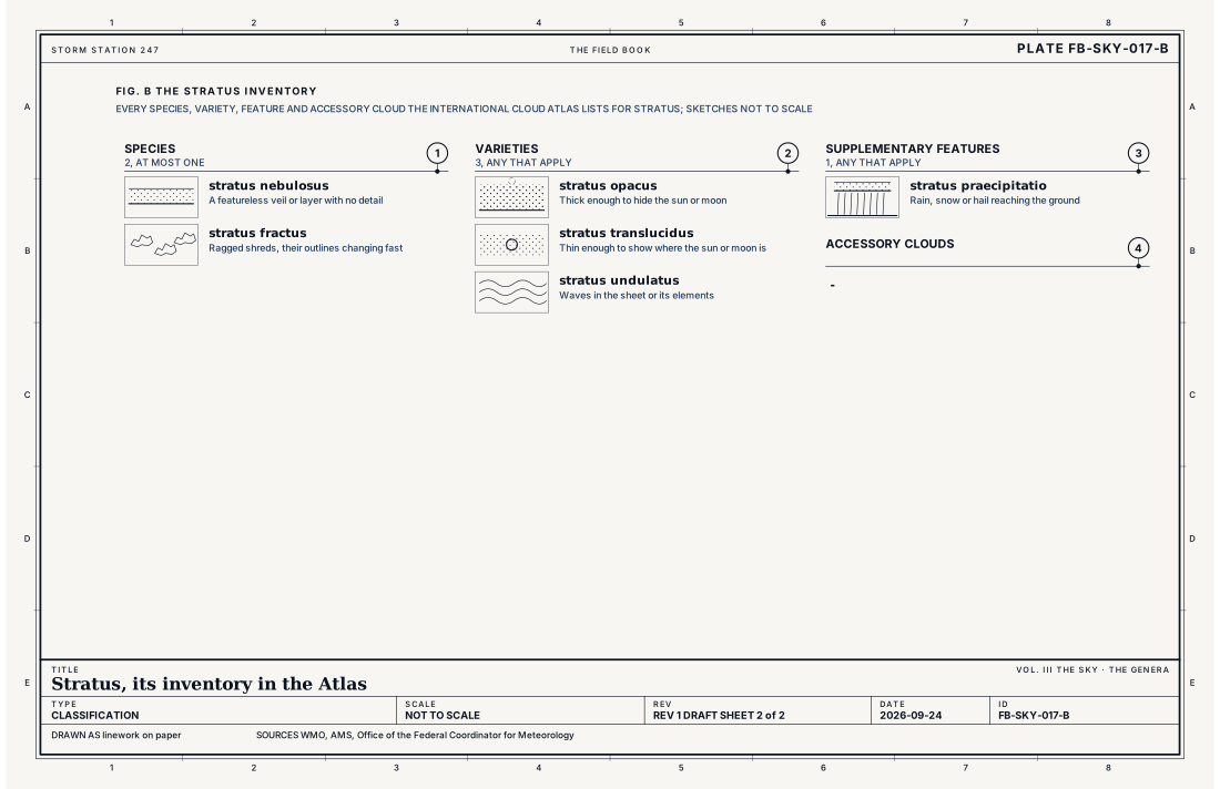
- Species, at most one
- Varieties, any that apply
- Supplementary features, any that apply
- Accessory clouds, any that apply
Ingredients
- Moist air near the ground cooled to its dew point, by the ground cooling at night or by moist air moving over cold ground or water
- Light wind, which mixes the cooled air through a shallow layer
- An inversion above, which holds the moist air near the ground
Scales
- time
- hours; it often forms overnight and lifts or breaks by midday
- horizontal
- a valley to hundreds of miles of coast
- vertical
- a few hundred feet to about 1,600 ft (500 m) deep
- orlanski
- meso
Signatures
- surface
- a low ceiling in the sky report; drizzle and poor visibility
- satellite
- smooth and bright in the visible, close to the ground's temperature in the infrared
- radar
- no echo, or very light drizzle
The numbers
| Quantity | Value, and the kind of number it is |
|---|---|
| Abbreviation | StStandard, International Cloud Atlas |
| Étage | Low: from the ground to 6,600 ft (2 km)Standard, International Cloud Atlas |
| Made of | Water droplets; ice crystals when very coldStandard, International Cloud Atlas |
| What falls | Drizzle, snow grains or ice prisms, when anything fallsStandard, International Cloud Atlas |
| Fog | Stratus with its base at the ground is fogStandard, Glossary of Meteorology |
| Species | 2: nebulosus, fractusStandard, International Cloud Atlas |
| Varieties | 3: opacus, translucidus, undulatusStandard, International Cloud Atlas |
| Supplementary features | 1: praecipitatioStandard, International Cloud Atlas |
| Accessory clouds | -Standard, International Cloud Atlas |
| Airport ceilometer | Cloud bases to 12,000 ft (3.7 km) overheadStandard, Automated Surface Observing System (ASOS) User's Guide |
| Ceiling | The height of the lowest layer reported broken or overcastStandard, Federal Meteorological Handbook No. 1 |
How the station sees it
An airport station measures stratus directly: the laser ceilometer reports its base, often only a few hundred feet, and its cover, usually broken or overcast. The lowest broken or overcast layer is the ceiling, and a low stratus ceiling is what closes airports to visual flight. The station reports the drizzle and the reduced visibility beneath it. It does not name the genus.
- Airport weather stations: the cover and height of each layer overhead, to 12,000 ft
How it is warned
The cloud is not warned. When it lowers to the ground as fog thick enough to cut visibility sharply, the Weather Service can issue a Dense Fog Advisory for drivers. Freezing drizzle from stratus below 32 °F (0 °C) glazes roads with little warning from the sky; the Weather Service covers it in a Winter Weather Advisory. For aircraft, stratus ceilings are forecast hour by hour.
See also
- Cloud classification FB-SKY-001
- Nimbostratus FB-SKY-015
- Stratocumulus FB-SKY-016
- Drizzle FB-WAT-011
- Fog types FB-WAT-020
Sources
- World Meteorological Organization. International Cloud Atlas.
- American Meteorological Society. Glossary of Meteorology.
- Office of the Federal Coordinator for Meteorology. Federal Meteorological Handbook No. 1, Surface Weather Observations and Reports.
- National Weather Service. Automated Surface Observing System (ASOS) User's Guide.
Definition after the International Cloud Atlas. Plate FB-SKY-017, revision 1, 2026-09-24. The number is permanent; cite it.