What it is
A thunderstorm is a cumulonimbus that makes lightning. The AMS Glossary defines it by the lightning and the thunder, not by the rain: a storm with no thunder is a shower, however hard it rains.
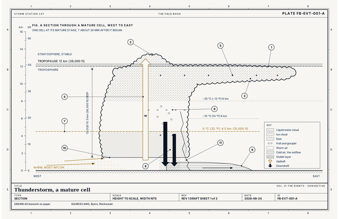
The storm is a heat engine the height of the troposphere. Warm, moist air near the ground is the fuel. The updraft is the piston: a column of air that rises because it is warmer, and so lighter, than the air around it. Condensation is the fuel burning: every gram of water vapour that condenses releases about 2.5 kJ of latent heat into the column, which keeps it warmer than its surroundings and keeps it rising. The anvil is the exhaust, spread out under the tropopause where the rising air can go no higher. Rain, hail and the downdraft they drag with them are the engine running down.
A single cell lives 30 to 60 minutes. A storm that lasts for hours is a storm that makes new cells, one after another, or one whose single updraft is organized to survive; those are other plates.
What it is not
A thunderstorm is not the same thing as a severe thunderstorm. Severe is an operational threshold the Weather Service sets: hail 2.5 cm (1 in) across or larger, a gust of 26 m s⁻¹ (58 mph) or more, or a tornado. Most thunderstorms never reach it. Lightning does not count toward it, and lightning kills people in storms that are not severe.
It is not a tornado, and it is not a supercell. A tornado is a small part of some storms. A supercell is a thunderstorm with a deep, persistent, rotating updraft, Supercell FB-EVT-007. The ordinary cell drawn here has no rotation that matters.
It is not the cloud. A cumulonimbus is the cloud's name in the WMO International Cloud Atlas, Cumulonimbus FB-SKY-019. The thunderstorm is what the cloud does.
Lookalikes
- Towering cumulus
- The same machine, stopped short: no ice aloft and no lightning. It becomes a thunderstorm only when it freezes and charges.
- Heat lightning
- Not a kind of lightning. It is a distant thunderstorm's lightning, seen where its thunder cannot be heard.
- Severe thunderstorm
- The same storm past an operational threshold of hail, wind or a tornado. Lightning alone never makes a storm severe.
The machine
Byers and Braham drew the life of one cell in 1949, from aircraft flown through storms in Florida and Ohio, and the three stages they named are still how the cell is taught. Fig. B draws them.
- Cumulus stage, about 0 to 15 minutes. Lift carries a parcel to its level of free convection. From there it rises on its own buoyancy. Updraft fills the whole cloud. The tower climbs past the freezing level near 4.5 km (15,000 ft), and the water in it stays liquid well below 0 °C: supercooled.
- Mature stage, about 15 to 30 minutes. Ice forms aloft. Drops and ice grow large enough to fall through the updraft, and as they fall they drag air down with them and cool it by evaporating into it. Now there is a downdraft beside the updraft. Rain reaches the ground; this is when the storm is strongest, and when the lightning starts. The top reaches the tropopause and spreads as the anvil. If the updraft is strong enough to carry air past the tropopause, a dome stands above the anvil: the overshooting top.
- Dissipating stage, about 30 minutes on. The downdraft spreads through the lower cloud and cuts the updraft off from its fuel. Rain becomes lighter and steadier. The anvil drifts on, a cirrus sheet with no engine under it.
The downdraft does not stop at the ground. It spreads out along the surface as a pool of cold air, and its leading edge is the gust front: the sudden, cool wind that arrives a few minutes before the rain. Where the gust front meets warm, moist air it lifts it, and a new cell may grow there. That is how a storm becomes many storms.
The charge
The leading explanation for the charge is collisions between graupel (soft hail) and small ice crystals in the presence of supercooled water. In the main charging zone, colder than about −10 °C (14 °F), graupel takes a negative charge and the crystals a positive one. The updraft carries the crystals up into the anvil; the graupel stays lower. That builds the tripole of Fig. A: positive charge in the anvil, the main negative charge between about −10 and −25 °C, and a smaller positive charge near the freezing level. The mechanism is supported by laboratory work and field measurement, but the details of how charge sign depends on temperature and water content are still argued. The Book labels it the leading mechanism, not a settled law.
When the field between the charge regions is strong enough, the air breaks down. A stepped leader works down from the negative region; an upward streamer meets it; the return stroke heats the channel to near 30,000 K (54,000 °F) for microseconds. The air expands at once. That shock, stretched along a channel kilometres long, is thunder.
The numbers that decide it
Whether a lifted parcel becomes a storm is a question of buoyancy, integrated through the depth it can rise. That integral is CAPE, and the equation for it is given below the figures. Parcel theory gives an upper bound on the updraft, . With 1,000 J kg⁻¹ of CAPE, that is about 45 m s⁻¹ (100 mph). Real updrafts reach about half of it, because the rising air mixes with drier air around it and carries the weight of its own water.
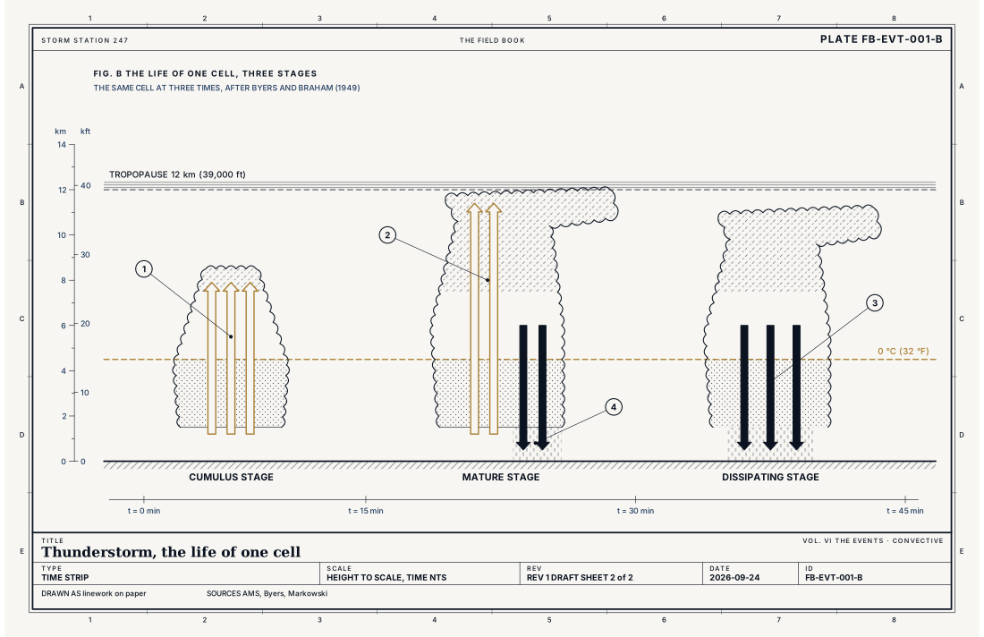
- Cumulus stage, updraft throughout
- Mature stage, updraft and downdraft side by side
- Dissipating stage, downdraft throughout
- Rain reaches the ground
Ingredients
- Moisture in the lowest 1 to 2 km (3,300 to 6,600 ft)
- Instability, a lapse rate steep enough that a lifted parcel becomes warmer than its surroundings (positive CAPE)
- Lift to the level of free convection, from a front, an outflow boundary, terrain or the day's heating
- Not required: wind shear. Shear organizes a storm into a multicell or a supercell; without it the cell rains into its own updraft and dies
Scales
- time
- 30 to 60 minutes for one cell; hours for a storm that renews itself
- horizontal
- 5 to 10 km (3 to 6 mi) for one cell
- vertical
- the troposphere, cloud base to the tropopause at 10 to 16 km (33,000 to 52,000 ft)
- orlanski
- meso-gamma
Equations
Convective available potential energy
- the buoyant energy of a rising parcel, J kg⁻¹
- gravity, 9.81 m s⁻²
- virtual temperature of the parcel, K
- virtual temperature of the environment at the same height, K
- the level of free convection and the equilibrium level
Assumes Parcel theory. The parcel does not mix with its surroundings, its pressure equals the environment's, and the weight of its condensed water is neglected.
Working form , the fastest the updraft could rise if every joule became motion. Mixing and the weight of water keep real updrafts to about half of it.
Signatures
- sounding
- positive CAPE; moisture below 850 hPa; a lifting condensation level within reach of the day's lift
- radar
- a reflectivity core of 40 to 50 dBZ or more, first aloft, then descending as the cell matures; an echo top that climbs toward the tropopause
- satellite
- cloud tops cooling fast in the infrared; an anvil spreading downwind; an overshooting top over a strong updraft
- surface
- a wind shift and a gust as the gust front passes; a drop in temperature; a jump in pressure; then the heaviest rain
The numbers
| Quantity | Value, and the kind of number it is |
|---|---|
| Cloud base | 0.5 to 2.5 km (1,600 to 8,200 ft) above the ground, the lifting condensation levelTypical, Wallace 2006 |
| Cloud top | Near the tropopause, 10 to 16 km (33,000 to 52,000 ft); higher in an overshooting topTypical, Wallace 2006 |
| Freezing level in summer | About 4 to 5 km (13,000 to 16,000 ft) at middle latitudesTypical, Wallace 2006 |
| Updraft | 5 to 20 m s⁻¹ (11 to 45 mph) in an ordinary cell; 25 to 50 m s⁻¹ (56 to 112 mph) or more in a severe stormTypical, Markowski 2010 |
| Life of one cell | 30 to 60 minutes, in three stages: cumulus, mature, dissipatingTextbook, Byers 1949 |
| Width of one cell | 5 to 10 km (3 to 6 mi)Typical, Byers 1949 |
| Main negative charge | Between about −10 and −25 °C (14 and −13 °F), roughly 6 to 8 km (20,000 to 26,000 ft) in summerTextbook, Rakov 2003 |
| Lightning channel | Peaks near 30,000 K (54,000 °F) for a few microsecondsTextbook, Rakov 2003 |
| Thunder | Rarely heard beyond about 25 km (15 mi)Textbook, Rakov 2003 |
| Flash to bang | About 3 seconds a kilometre (5 seconds a mile): sound travels 343 m s⁻¹ (767 mph) at 20 °CTextbook, Wallace 2006 |
| Severe | Hail 2.5 cm (1 in) across or larger, a gust of 26 m s⁻¹ (58 mph, 50 kt) or more, or a tornadoStandard, Directive 10-511 |
How the station sees it
No one instrument sees a whole thunderstorm. Each sees one part of it, and the storm is what they agree on.
The radar on the live map sees the rain and hail inside the cell: a core of 40 to 50 dBZ or more that first appears aloft, then descends as the cell matures. A tall core of high reflectivity above the freezing level is one of the radar's best hail signals.
The airport weather stations in the instrument atlas see the gust front before they see the rain. In their one minute records it arrives as a wind shift and a gust, a fall in temperature of several degrees in a few minutes, and a sharp rise in pressure: the weight of the cold pool arriving. Then the rain rate climbs. Many report thunder heard at the station.
A personal weather station in a backyard sees the same signature at its own spot, and a dense network of them can draw the gust front's edge across a city in more detail than the airports alone.
What the station does not see is lightning directly. Lightning networks locate strokes by the radio pulses they emit; the site does not draw them yet.
- Airport weather stations: the gust, the pressure jump, the temperature drop, the rain rate and thunder heard
- Road weather stations: wind and visibility along the highways
- The radar on the live map: the rain and hail inside the cell, every few minutes
How it is warned
The Weather Service issues a Severe Thunderstorm Watch when the ingredients for severe storms are present over a large area for several hours, and a Severe Thunderstorm Warning when a storm is producing, or about to produce, severe hail or wind. A Tornado Warning is issued when radar or a trained spotter indicates a tornado. A storm that is strong but below the threshold may get a Special Weather Statement.
A warning on this site is drawn on the counties it covers, with a heavy outline around the polygon the forecaster drew around the storm. The full text names the hazard, where the storm is, where it is moving and what to do.
The safety rule for lightning does not wait for a warning: when thunder roars, go indoors, and stay there until 30 minutes after the last thunder. How to read the warning itself is How to read a warning FB-STN-001.
| VTEC | Phenomenon | The alerts that carry it |
|---|---|---|
SV | severe thunderstorm | Severe Thunderstorm Warning; Severe Thunderstorm Watch |
TO | tornado | Tornado Warning; Tornado Watch |
Weather radio (SAME) codes: SVA SVR SVS TOA TOR SPS
See also
- Supercell FB-EVT-007
- Severe thunderstorm, the operational definition FB-EVT-023
- Cumulonimbus FB-SKY-019
- Cumulonimbus architecture FB-SKY-041
- CAPE, CIN and the sounding FB-ENG-006
- Lightning types FB-SKY-060
- Microburst and heat burst FB-EVT-020
- How to read a warning FB-STN-001
- WSR-88D radar FB-INS-005
Sources
- American Meteorological Society. Glossary of Meteorology.
- Byers, H. R. and R. R. Braham. The Thunderstorm, Report of the Thunderstorm Project (1949).
- Markowski, P. and Y. Richardson. Mesoscale Meteorology in Midlatitudes (2010).
- Rakov, V. A. and M. A. Uman. Lightning, Physics and Effects (2003).
- Wallace, J. M. and P. V. Hobbs. Atmospheric Science, An Introductory Survey, 2nd ed. (2006).
- National Weather Service. Directive 10-511, WFO Severe Weather Products Specification.
- National Weather Service. Lightning Safety.
Definition after the Glossary of Meteorology. Plate FB-EVT-001, revision 1, 2026-09-24. The number is permanent; cite it.