What it is
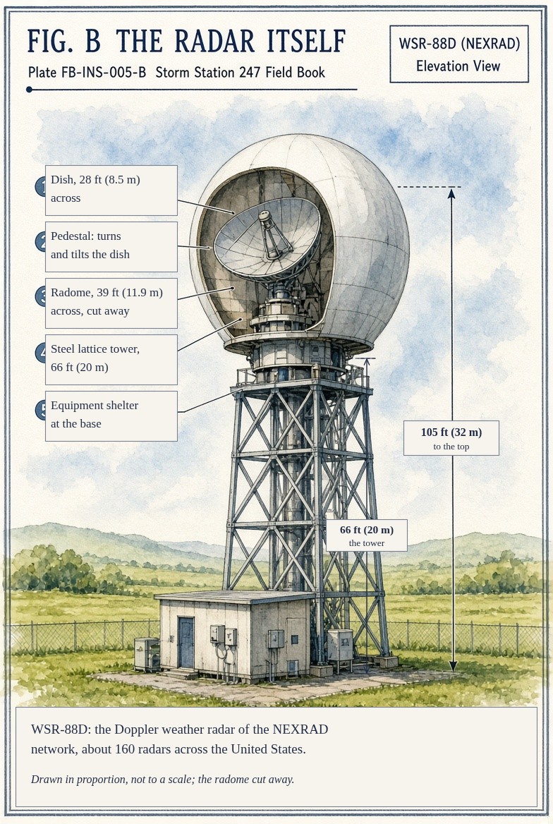
The WSR-88D, the Weather Surveillance Radar of 1988 with Doppler, is the weather radar of the United States. About 160 of them cover the country and its territories. Each is a dish 28 ft (8.5 m) across, turning inside a radome on a tower, that sends pulses of microwaves about 3.9 in (10 cm) long with a peak power of 750 kW and listens for their echoes.
Three things are measured from each echo. The time it takes to return gives the range. Its strength gives the reflectivity, how much the air in that cell returns. The change in its phase from one pulse to the next gives the radial velocity, how fast the targets move toward or away from the radar. Since 2013 every radar also sends its pulses in two polarizations, horizontal and vertical, and comparing the two echoes tells the shape and the mix of what it hit.
The beam is 0.95 degree wide. The radar sweeps a full circle at 0.5 degree above the horizon, then steps up through higher angles to 19.5 degrees, completing a volume every 4 to 10 minutes, depending on the pattern the forecasters choose for the weather.
What it is not
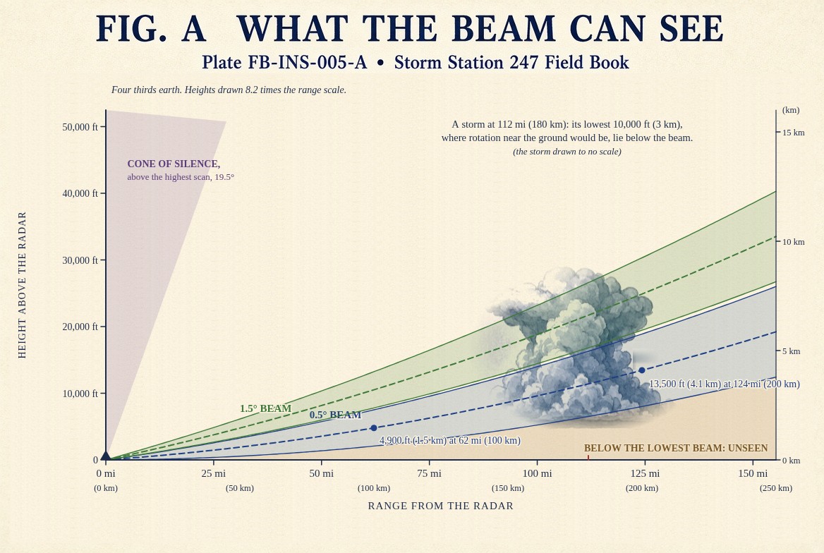
It does not see the ground. The earth curves away under the beam, so the beam rises with range, Fig. A. At 0.5 degree its centre is 4,800 ft (1.5 km) above the radar at 62 mi (100 km) and 13,400 ft (4.1 km) at 124 mi (200 km). Far from a radar it looks over shallow rain, drizzle, lake effect snow and the lowest part of a storm, where a tornado forms.
It does not see across the beam. Doppler measures only the part of the motion toward or away from the radar. A wind blowing straight across the beam reads zero.
It does not see straight up. Above 19.5 degrees there is a cone of silence over every radar. In the West, mountains block the lowest scans.
It does not see only weather. An echo is anything that returns the pulse: rain, hail, snow, insects, birds, smoke, and the debris a tornado lifts. Where the beam bends down in a strong inversion or strikes a hill, it sees the ground.
Lookalikes
- The satellite image
- Looks down at cloud tops from space. Radar looks sideways through the storm at what is falling in it, Geostationary satellite FB-INS-006.
- Rain at the ground
- Radar sees the rain aloft, where its beam is. The rain gauge measures what arrives, What an instrument is FB-INS-001.
- A precipitation estimate
- Reflectivity turned into rain rate by a formula. It is an estimate from an instrument, and a gauge corrects it.
The machine
Reflectivity. The echo from a drop grows with the sixth power of its diameter, so a few large drops outweigh many small ones. The sum is so wide in range that it is kept in decibels, dBZ. A formula turns it into a rain rate: 40 dBZ is about half an inch an hour, 50 dBZ about two and a half. Hail breaks the formula, because hail is large and echoes as if it were torrential rain.
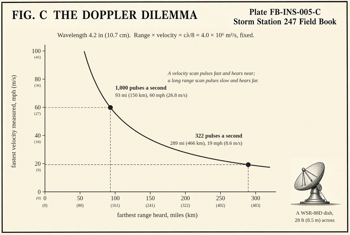
Velocity. Pulses must be far apart in time for the echo from a distant storm to return before the next one leaves, and close together to follow fast motion without the velocities folding over. Range and velocity cannot both be large: their product is fixed by the wavelength, Fig. C. The radar escapes by scanning the lowest angles twice, once with few pulses for range and once with many for velocity, and by unfolding velocities in software.
Polarization. Large raindrops flatten as they fall, so they echo more in the horizontal than in the vertical. Tumbling hail echoes about the same in both. A cell of all rain or all snow echoes the same way from pulse to pulse, and a mixture does not. From those comparisons the radar sorts rain, snow, hail and the melting layer, Dual polarization radar products FB-INS-010.
The drawings
Each figure drawn as an engineering sheet, its parts numbered, to print at 11 by 17.
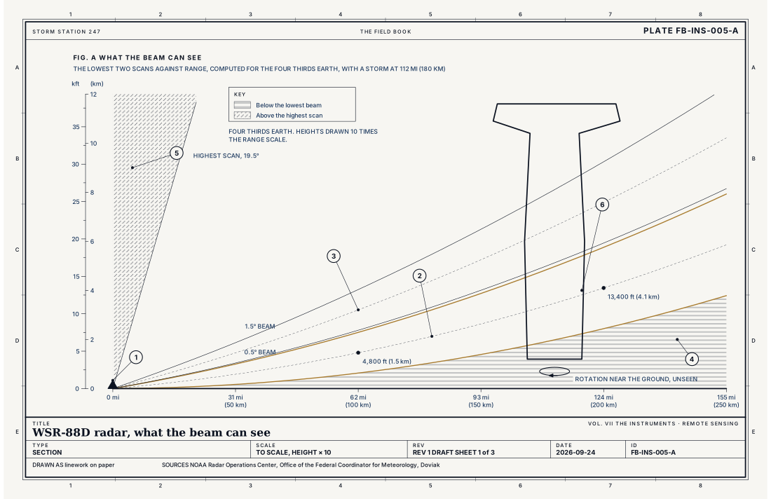
- The radar
- The 0.5 degree beam, its centre and its edges
- The 1.5 degree beam
- Below the beam, unseen
- The cone of silence, above 19.5 degrees
- A storm at 112 mi (180 km), its base under the beam
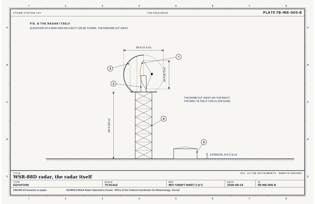
- The dish, 28 ft (8.5 m)
- The pedestal, which turns and tilts the dish
- The radome, 39 ft (11.9 m)
- The tower
- The equipment shelter
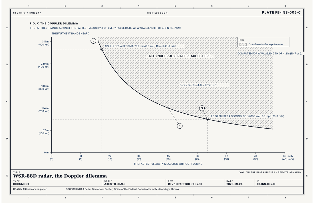
- The curve, range times velocity fixed
- A long range scan, 322 pulses a second
- A velocity scan, 1,000 pulses a second
Ingredients
- Pulses of microwaves about 3.9 in (10 cm) long, sent in a beam 0.95 degree wide
- The echo's delay, which gives the range\; its strength, which gives the reflectivity\; its phase from pulse to pulse, which gives the radial velocity
- Pulses in two polarizations, horizontal and vertical, whose echoes compared give the shape and mix of the targets
Scales
- time
- a full volume every 4 to 10 minutes\\; the lowest scan repeated more often in severe weather
- horizontal
- 286 mi (460 km) for reflectivity, 186 mi (300 km) for velocity\\; 0.5 degree by 820 ft (250 m) cells
- vertical
- the lowest beam at 4,800 ft (1.5 km) above the radar at 62 mi (100 km), 13,500 ft (4.1 km) at 124 mi (200 km)
- orlanski
- meso
Equations
The height of the beam
- the height of the beam's centre above the radar
- the range along the beam
- the elevation angle of the scan
- the radius of the earth, 6,371 km
- four thirds, the effective earth radius factor for standard refraction
Assumes The standard atmosphere bends the beam slightly downward, which the four thirds earth accounts for. In a strong inversion the beam bends more, and can reach the ground.
Working form At 0.5 degree: 0.58 km (1,900 ft) at 50 km, 1.46 km (4,800 ft) at 100 km, 2.63 km (8,600 ft) at 150 km, 4.10 km (13,400 ft) at 200 km. The beam is then 3.3 km (2.1 mi) wide.
The Doppler dilemma
- the farthest range heard before the next pulse leaves
- the fastest radial velocity measured without folding
- the speed of light, 3.00 × 10⁸ m s⁻¹
- the wavelength, about 0.107 m
- the pulses sent each second
Assumes A single pulse repetition frequency. The radar escapes the product by scanning twice at different rates and by unfolding velocities in software.
Working form At 322 pulses a second: 466 km and 8.6 m s⁻¹ (19 mph). At 1,000: 150 km and 26.8 m s⁻¹ (60 mph). The product stays 4.0 × 10⁶ m² s⁻¹.
Reflectivity and rain rate
- the reflectivity factor, the sum of the sixth powers of drop diameters in a cubic metre, mm⁶ m⁻³
- the diameter of each drop, mm
- the rain rate, mm h⁻¹
Assumes Drops small against the wavelength. The relation of Z to R is the default for convective rain\\; hail, snow and a melting layer break it.
Working form 30 dBZ is about 2.4 mm (0.09 in) an hour\; 40 dBZ about 12 mm (0.48 in)\; 50 dBZ about 63 mm (2.5 in). One drop 6 mm across echoes as strongly as 46,656 drops 1 mm across.
Signatures
- radar
- reflectivity in dBZ\\; radial velocity; inbound and outbound\\; differential reflectivity; correlation coefficient and specific differential phase
The numbers
| Quantity | Value, and the kind of number it is |
|---|---|
| Network | About 160 radars across the United States and its territoriesTypical, The WSR-88D |
| Band | S band, 2.7 to 3.0 GHz, a wavelength near 4 in (10 cm)Standard, The WSR-88D |
| Antenna | A dish 28 ft (8.5 m) across, beam 0.95 degree wideStandard, The WSR-88D |
| Peak power | 750 kWStandard, The WSR-88D |
| Range | 286 mi (460 km) for reflectivity\; 186 mi (300 km) for velocityStandard, The WSR-88D |
| Resolution | 0.5 degree in azimuth by 820 ft (250 m) in range at the lowest scansStandard, The WSR-88D |
| Scan | Elevations from 0.5 to 19.5 degrees\; a full volume every 4 to 10 minutesStandard, The WSR-88D |
| Dual polarization | Across the network since 2013Standard, The WSR-88D |
| Rain rate | Z = 300 R to the power 1.4 by default in convective rainStandard, The WSR-88D |
How the station sees it
The radar layer on the live map is the lowest scan of each radar in the network, joined into one national mosaic and refreshed every few minutes. Because the lowest scan climbs with range, a storm far from any radar is shown as it is several kilometres up, and light rain there may not show at all.
- The radar layer on the live map: the lowest scan of each radar, joined into one national mosaic
- The alerts: the tornado and severe thunderstorm warnings issued on radar evidence, each naming its source
How it is warned
Most tornado and severe thunderstorm warnings are issued on radar evidence, often before anyone sees the storm. A tornado warning names its source. Radar indicated rotation is a tight pair of inbound and outbound velocities near the ground. Radar confirmed tornado is a debris signature: debris lifted by the tornado, seen as strong reflectivity where the two polarizations disagree, beside the rotation. Observed means a person saw it, Tornado FB-EVT-009.
See also
- Dual polarization radar products FB-INS-010
- What an instrument is FB-INS-001
- Geostationary satellite FB-INS-006
- Tornado FB-EVT-009
- Supercell FB-EVT-007
- Thunderstorm FB-EVT-001
- Flash flood FB-EVT-100
Sources
- NOAA Radar Operations Center. The WSR-88D, system description and operations.
- Office of the Federal Coordinator for Meteorology. Federal Meteorological Handbook No. 11, Doppler Radar Meteorological Observations.
- Doviak, R. J. and D. S. Zrnic. Doppler Radar and Weather Observations, 2nd ed. (1993).
- American Meteorological Society. Glossary of Meteorology.
- National Weather Service. Directive 10-511, WFO Severe Weather Products Specification.
Definition after the Federal Meteorological Handbook No. 11, Doppler Radar Meteorological Observations. Plate FB-INS-005, revision 1, 2026-09-24. The number is permanent; cite it.