What it is
A wall cloud is a lowering of a thunderstorm's base, hanging beneath its strongest updraft. Its sides are steep and its base can be well below the rest of the storm's. In a classic supercell, Supercell FB-EVT-007, moving toward the northeast, it hangs at the rear of the rain, often on the storm's southwest side. It is typically 1 to 4 mi (1.6 to 6.4 km) across. The International Cloud Atlas names it murus, one of the supplementary features of cumulonimbus, Cumulonimbus FB-SKY-019.
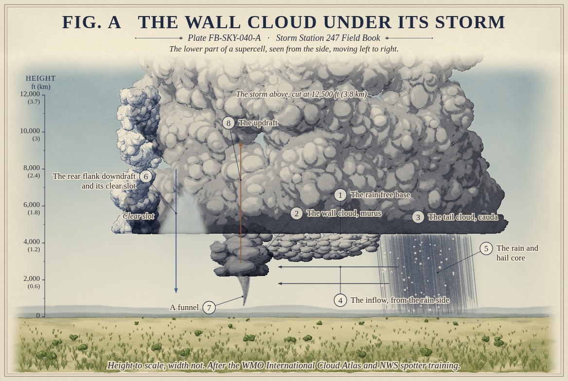
Fig. A draws it under its storm. A tail cloud, cauda, often runs from the wall back toward the rain, with the moist air flowing along it into the wall. Behind the wall, the rear flank downdraft can carve a clear slot of sky.
What it is not
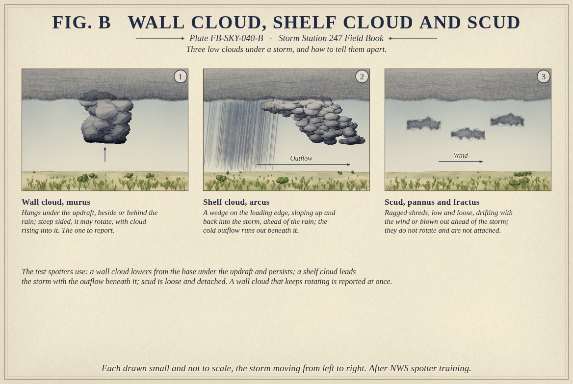
It is not a shelf cloud. A shelf cloud is a wedge on the storm's leading edge, ahead of the rain, with the cold outflow running out beneath it; it sits where air is sinking and spreading, and a wall cloud sits where air is rising. It is not scud, the loose ragged shreds that drift under a storm and are not attached to its base. Fig. B draws the three side by side, as spotters are taught to tell them apart.
It is not a tornado. Most wall clouds never produce one.
Lookalikes
- Shelf cloud
- A wedge on the storm's leading edge, ahead of the rain, with the cold outflow beneath it; it does not rotate about a vertical axis
- Scud
- Ragged shreds, loose and detached, drifting with the wind
- Funnel cloud
- A funnel descends from the wall cloud; the wall cloud is the broader lowering it comes from
The machine
The wall cloud is the updraft made visible. A supercell's updraft draws in air from near the ground, and some of that air has passed through the rain. The rain has cooled and moistened it, so as it rises it reaches its dew point sooner, at a lower height than the air elsewhere under the storm: the base lowers there, into a wall. The tail cloud is the same moist inflow condensing on its way in.
When the storm's updraft rotates, as in a supercell's mesocyclone, the wall cloud can be seen to rotate with it, and cloud can be seen rising rapidly into it. The rear flank downdraft wraps around the wall from behind. It is in that meeting of rotating updraft and wrapping downdraft that most strong tornadoes form, often within minutes to an hour of a wall cloud beginning to rotate, Tornado FB-EVT-009. A funnel that descends from the wall cloud is the first sign.
The drawings
Each figure drawn as an engineering sheet, its parts numbered, to print at 11 by 17.
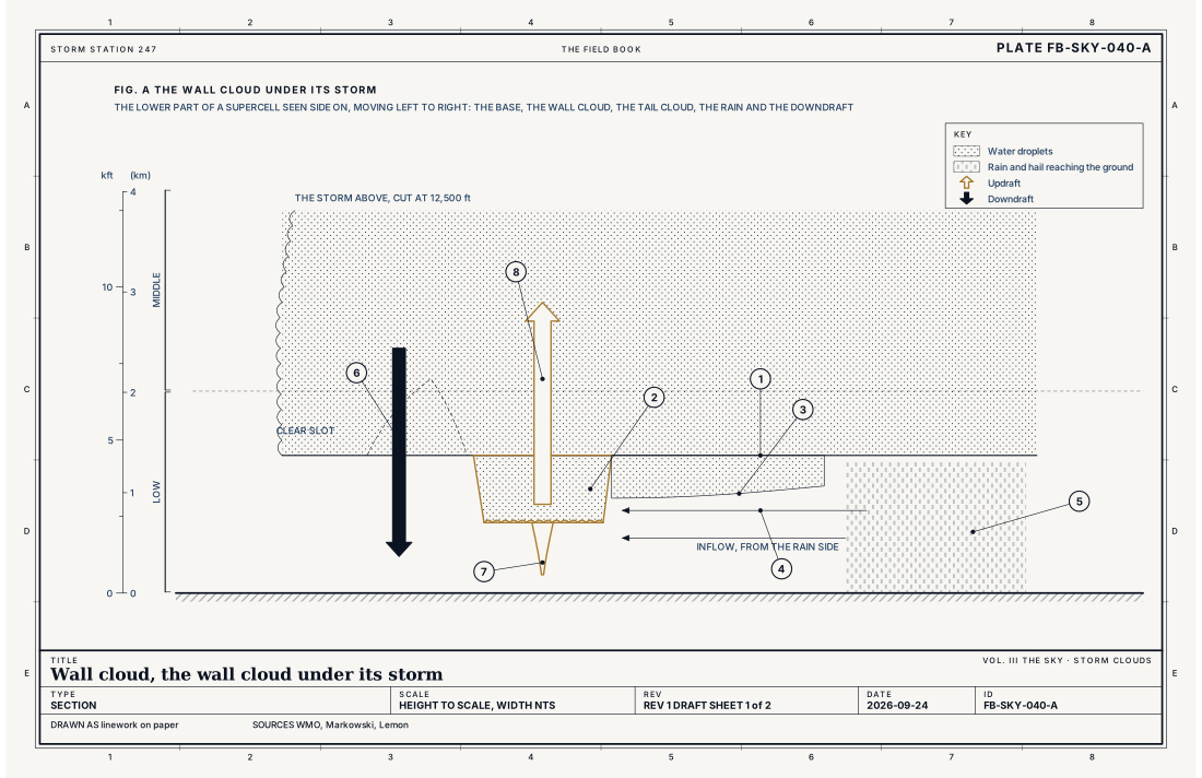
- The rain free base
- The wall cloud, murus
- The tail cloud, cauda
- The inflow, from the rain side
- The rain and hail core
- The rear flank downdraft and its clear slot
- A funnel
- The updraft
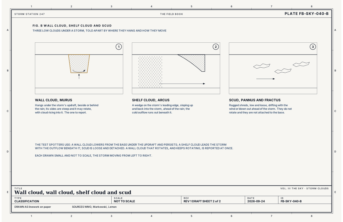
- Wall cloud, murus
- Shelf cloud, arcus
- Scud, pannus and fractus
Ingredients
- A strong, lasting updraft, as in a supercell
- Moist air near the ground drawn into it, cooled by the rain so it condenses at a lower height
- For rotation, a mesocyclone: the updraft turning, from wind that changes with height
Scales
- time
- minutes to an hour
- horizontal
- typically 1 to 4 mi (1.6 to 6.4 km) across
- vertical
- a few hundred to a few thousand feet below the storm's base
- orlanski
- meso gamma
Signatures
- surface
- seen, not measured: spotters report its rotation, its motion and any funnel
- radar
- a hook of echo wrapping round the updraft, and a rotation couplet in the velocity data above the wall cloud
- satellite
- an overshooting top above the updraft
The numbers
| Quantity | Value, and the kind of number it is |
|---|---|
| Atlas name | Murus, a supplementary feature of cumulonimbus; the tail cloud is caudaStandard, International Cloud Atlas |
| Size | Typically 1 to 4 mi (1.6 to 6.4 km) acrossTypical, Markowski 2010 |
| Where it hangs | Under the updraft, at the rear of the rain in a classic supercell moving northeast, so often on the storm's southwest sideTextbook, Lemon 1979 |
| Severe thunderstorm | Hail of 1 inch (2.5 cm) or more, a gust of 58 mph (50 knots, 26 m/s) or more, or a tornadoStandard, Directive 10-511 |
| Airport ceilometer | Cloud bases to 12,000 ft (3.7 km) overheadStandard, Automated Surface Observing System (ASOS) User's Guide |
How the station sees it
No instrument sees a wall cloud; spotters do. A station under the storm records what comes with it: the gust front, the pressure jump and the rain. Radar sees the updraft region as an echo free vault with a hook of rain wrapping around it, and the rotation above the wall cloud in its velocity data. What the radar cannot see, near the ground under the wall, is what a spotter reports.
- Airport weather stations: the gust, the pressure jump and the rain as the storm passes
- The radar on the live map: the rain and hail falling from the storm, every few minutes
How it is warned
A rotating wall cloud is one of the reports that leads the Weather Service to issue or extend a Tornado Warning. Spotters report its location, its direction of motion, whether it is rotating, and any funnel; the report goes into the warning's text as the source, How to read a warning FB-STN-001. For anyone who sees one, the warning's advice applies at once: move to shelter before the funnel reaches the ground.
See also
- Cumulonimbus FB-SKY-019
- Cumulonimbus architecture FB-SKY-041
- Supercell FB-EVT-007
- Tornado FB-EVT-009
- Thunderstorm FB-EVT-001
- How to read a warning FB-STN-001
Sources
- World Meteorological Organization. International Cloud Atlas.
- Markowski, P. and Y. Richardson. Mesoscale Meteorology in Midlatitudes (2010).
- Lemon, L. R. and C. A. Doswell III. Severe Thunderstorm Evolution and Mesocyclone Structure as Related to Tornadogenesis, Monthly Weather Review 107 (1979).
- National Weather Service. Directive 10-511, WFO Severe Weather Products Specification.
- National Weather Service. Automated Surface Observing System (ASOS) User's Guide.
Definition after the International Cloud Atlas. Plate FB-SKY-040, revision 1, 2026-09-24. The number is permanent; cite it.