What it is
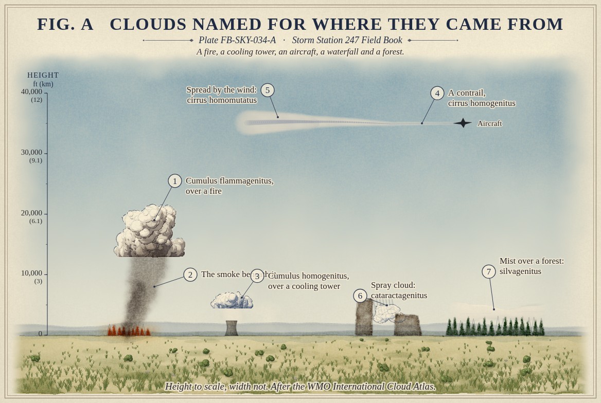
Most clouds are named for their shape, Cloud classification FB-SKY-001. A few are named for where they came from. The International Cloud Atlas calls them special clouds and keeps the name of the genus each one looks like, with a word for its origin added: flammagenitus, from a fire; homogenitus, from human activity; homomutatus, a cloud of human origin changed past recognition; cataractagenitus, from the spray of a waterfall; and silvagenitus, from a forest.
So the cumulus that towers over a large wildfire is cumulus flammagenitus, the pyrocumulus of fire crews; the cumulus over a power station's cooling tower is cumulus homogenitus; and a contrail is cirrus homogenitus, until the wind spreads it into a sheet no longer recognisable as a trail, when it becomes cirrus homomutatus. Fig. A draws each.
What it is not
It is not smoke. Smoke is dry particles; a fire cloud is the water cloud that forms on top of the smoke, where the rising air has cooled enough to condense. It is not fog, which forms over a wide area rather than from one source.
Lookalikes
- Smoke
- Dry particles, not water or ice; a fire cloud is the cloud that forms on top of the smoke
- Cirrus
- Natural high ice cloud; a spread contrail becomes cirrus homomutatus
- Fog
- Cloud at the ground, formed over a wide area rather than from one source
The machine
Every special cloud has a local source of heat or of water vapour. A fire heats the air and adds water from the burning fuel, and the plume rises until it reaches its condensation level; over a very large fire it can grow into cumulonimbus flammagenitus, a pyrocumulonimbus, with lightning of its own, Pyroconvection FB-EVT-141.
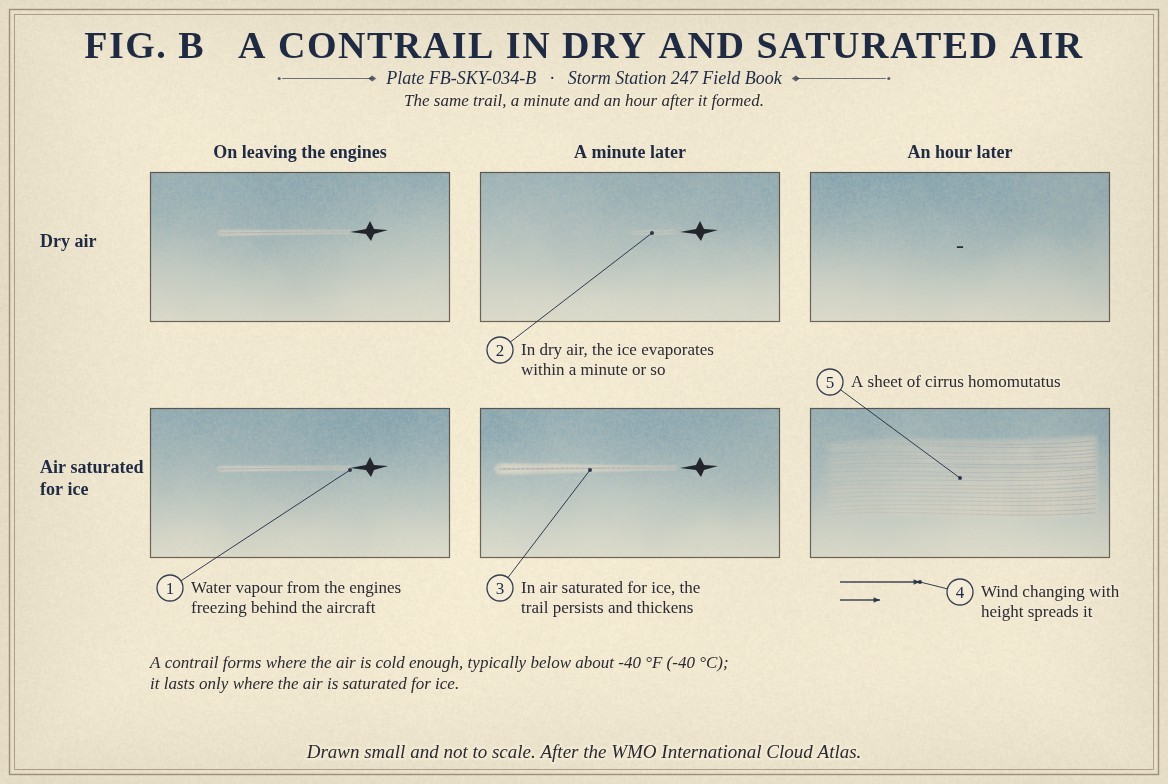
A contrail is water vapour from an aircraft's engines, frozen at once in air colder than about -40 °F (-40 °C). Fig. B follows one. In dry air its ice evaporates within a minute or so. In air saturated for ice it lasts, and the wind, changing with height, spreads it into a sheet that can cover a large part of the sky.
The drawings
Each figure drawn as an engineering sheet, its parts numbered, to print at 11 by 17.
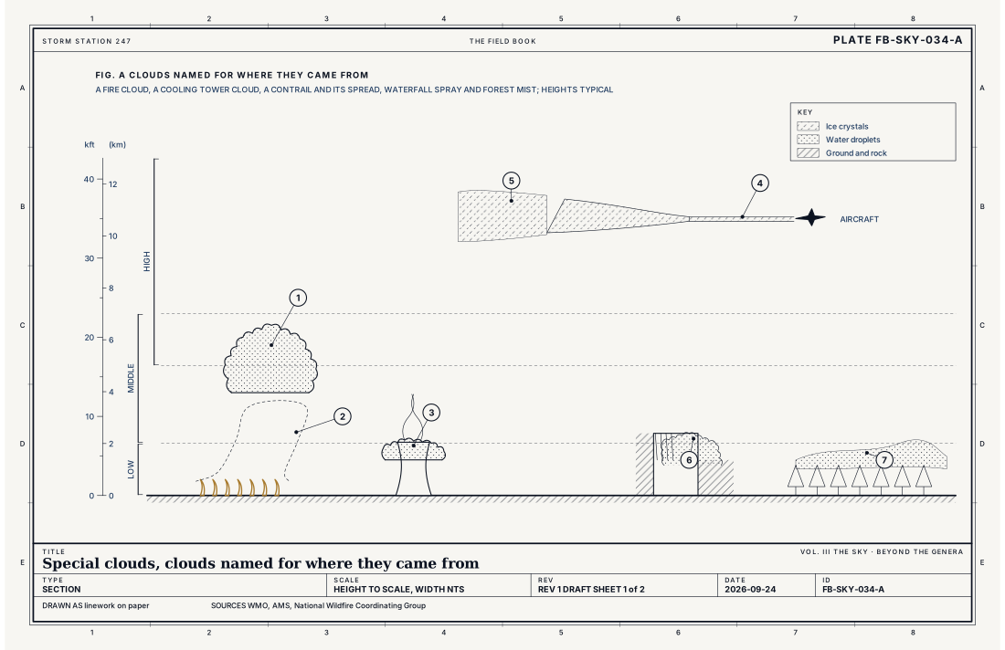
- Cumulus flammagenitus, over a fire
- The smoke beneath it
- Cumulus homogenitus, over a cooling tower
- A contrail, cirrus homogenitus
- Spread by the wind: cirrus homomutatus
- Spray cloud: cataractagenitus
- Mist over a forest: silvagenitus
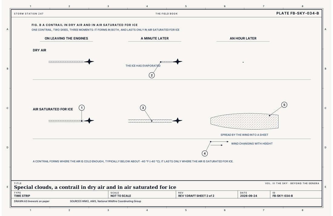
- Water vapour from the engines freezing behind the aircraft
- In dry air, the ice evaporates within a minute or so
- In air saturated for ice, the trail persists and thickens
- Wind changing with height spreads it
- A sheet of cirrus homomutatus
Ingredients
- A local source of heat or of water vapour: a fire, a power station, an engine, a waterfall, a wet forest
- Air near saturation, so the extra heat or vapour carries it to condensation
- For a contrail, air cold enough that the engines' water vapour freezes at once
Scales
- time
- a minute for a short contrail; hours for a spreading one or a fire cloud
- horizontal
- a few hundred feet over a tower; hundreds of miles for spread contrails
- vertical
- a few hundred feet for spray and forest mist; to 50,000 ft (15 km) for a fire cloud that becomes a thunderstorm
- orlanski
- micro to meso
Signatures
- surface
- smoke and a sudden cumulus over a fire; a line of cloud along a flight path
- satellite
- long thin lines of contrail, and spread sheets from them; a fire cloud's cold top over a hot spot
- radar
- smoke and ash echo from a large fire, and rain and hail from a fire cloud that has become a thunderstorm
The numbers
| Quantity | Value, and the kind of number it is |
|---|---|
| Names, by origin | flammagenitus (fire), homogenitus (human activity), homomutatus (a homogenitus cloud changed past recognition), cataractagenitus (waterfall), silvagenitus (forest)Standard, International Cloud Atlas |
| How a name is made | The genus, then the origin: cumulus flammagenitus, cirrus homogenitusStandard, International Cloud Atlas |
| Pyrocumulonimbus | Cumulonimbus flammagenitus: a fire cloud tall enough to make lightningStandard, International Cloud Atlas |
| Contrail formation | Typically where the air is colder than about -40 °F (-40 °C)Typical, Glossary of Meteorology |
| Contrail persistence | Only where the air is saturated with respect to iceTextbook, Glossary of Meteorology |
| Airport ceilometer | Cloud bases to 12,000 ft (3.7 km) overheadStandard, Automated Surface Observing System (ASOS) User's Guide |
How the station sees it
An airport station reports special clouds as it reports any cloud, by cover and base height, without the name. Satellites see spreading contrails as long straight lines and sheets, and a fire cloud as a cold top over a hot spot.
- Airport weather stations: the cover and height of each layer overhead, to 12,000 ft
How it is warned
The clouds are not warned; what makes them can be. A Red Flag Warning is issued for the weather that lets fires spread, Fire weather FB-EVT-139, and a fire cloud over a wildfire means the fire has taken over its own weather.
See also
- Cloud classification FB-SKY-001
- Cirrus FB-SKY-010
- Cumulus FB-SKY-018
- Cumulonimbus FB-SKY-019
- Fire weather FB-EVT-139
- Pyroconvection FB-EVT-141
- Dense smoke FB-EVT-136
Sources
- World Meteorological Organization. International Cloud Atlas.
- American Meteorological Society. Glossary of Meteorology.
- National Wildfire Coordinating Group. NWCG Glossary of Wildland Fire (PMS 205).
- National Weather Service. Automated Surface Observing System (ASOS) User's Guide.
Definition after the International Cloud Atlas. Plate FB-SKY-034, revision 1, 2026-09-24. The number is permanent; cite it.