What it is
Orographic clouds are clouds made by mountains. When wind blows across a ridge, the air is forced up the windward slope, cools and may condense; it sinks and warms down the lee slope; and in stable air it springs back and forth in a train of waves downwind. Each part of that flow makes its own cloud, and because the flow stays fixed to the mountain, so do the clouds: they stand still while the wind blows through them.
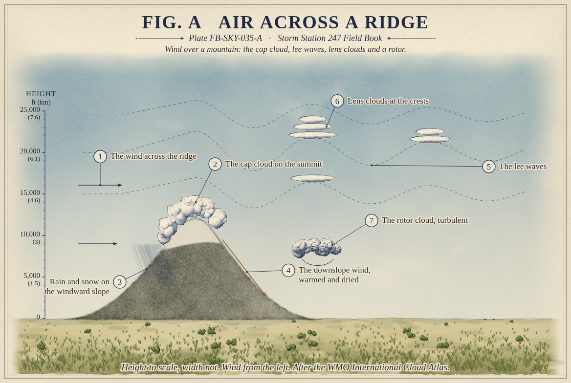
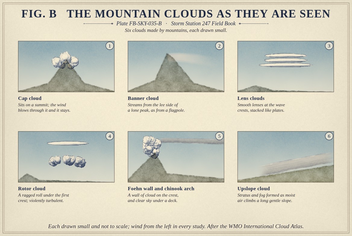
Fig. A draws the whole pattern. On the summit sits a cap cloud. On the windward slope rain or snow falls. In the lee the air descends as a warm, dry wind. Downwind, lens clouds stand at the wave crests, altocumulus lenticularis in the Atlas's naming, Altocumulus FB-SKY-013, often stacked like plates; and beneath the first crest a ragged rotor cloud rolls about a horizontal axis. Fig. B draws each one small, with the banner cloud, the foehn wall and the upslope cloud of the plains.
What it is not
A lens cloud is not an ordinary altocumulus. Ordinary cloud drifts with the wind; a lens cloud forms at its upwind edge and evaporates at its downwind edge, so the air passes through it and the cloud stays put. Its smooth, sharp edges have made it the cloud most often reported as a flying object.
A rotor cloud is not a shelf cloud. A shelf cloud leads a thunderstorm and moves with it; a rotor stands in the lee of a ridge while the wind holds.
Lookalikes
- Flying saucers
- Lens clouds are smooth, sharp edged and still, and are reported as unidentified objects more than any other cloud
- Ordinary altocumulus
- Moves with the wind; a lens cloud stands still while the wind blows through it
- Shelf cloud
- Leads a thunderstorm and moves with it; a rotor stands in the lee of a ridge
The machine
Air lifted over a ridge cools as it rises, and condenses if it reaches its dew point: the cap cloud forms on the way up and evaporates on the way down, which is why it sits on the summit and goes no farther. Much of the water falls out on the windward slope as rain or snow.
The air then descends the lee slope. With its water rained out, it warms at the dry rate, about 5.4 °F for every 1,000 ft (9.8 °C for every km), all the way down, and arrives warmer and drier than it left. East of the Rocky Mountains this is the chinook, which can raise the temperature by tens of degrees in an hour and take snow away without melting it into puddles. A wall of cloud stands on the crest while it blows, and downwind a band of clear sky lies under the cloud deck: the chinook arch.
Where the air is stable, the descending air overshoots, rises again and oscillates, and the ridge sets up standing waves downwind, Lapse rates and stability FB-ENG-005. Where a crest lifts a moist layer to saturation, a lens cloud forms. The rotor beneath the first crest is an eddy turning under the wave, and the air in it is among the most turbulent a pilot can meet. Where the flow is strong enough, the waves can break and bring violent downslope winds to the foothills.
The drawings
Each figure drawn as an engineering sheet, its parts numbered, to print at 11 by 17.
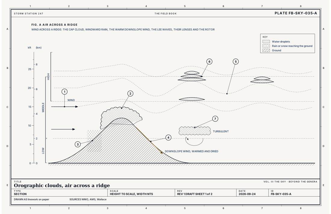
- The wind across the ridge
- The cap cloud on the summit
- Rain and snow on the windward slope
- The downslope wind, warmed and dried
- The lee waves
- Lens clouds at the crests
- The rotor cloud, turbulent
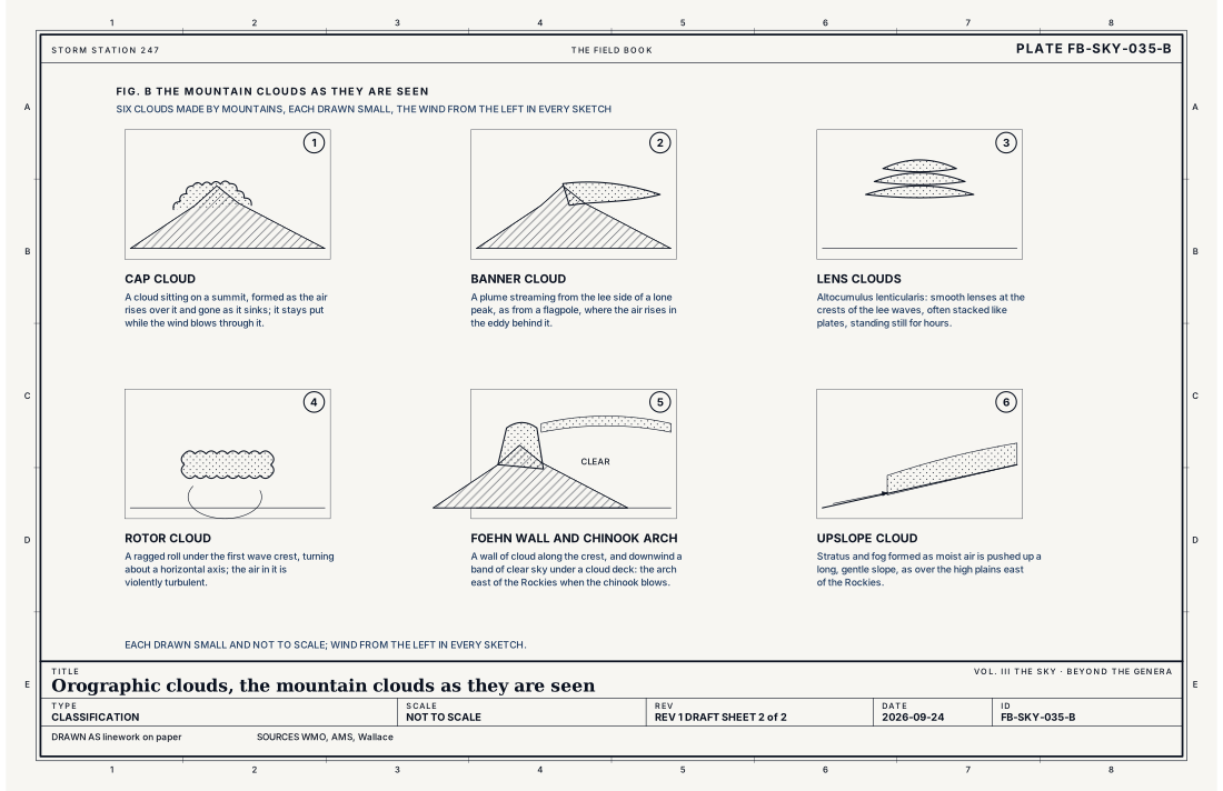
- Cap cloud
- Banner cloud
- Lens clouds
- Rotor cloud
- Foehn wall and chinook arch
- Upslope cloud
Ingredients
- Wind blowing across a ridge, strong and steady in direction
- Stable air, which springs back after it is lifted and so oscillates in waves downwind
- Moist layers at the heights where the air is lifted, where the crests reach saturation
Scales
- time
- hours; the clouds stay while the wind across the ridge holds
- horizontal
- a few miles to tens of miles downwind of the ridge
- vertical
- from the ridge to the tropopause for the tallest waves
- orlanski
- meso beta to meso gamma
Signatures
- surface
- a sharp rise in temperature and fall in humidity with a strong downslope wind; gusts
- satellite
- bands of wave cloud parallel to the ridge, fixed in place, and a clear strip in its lee
- radar
- snow and rain on the windward slope; little in the lee
The numbers
| Quantity | Value, and the kind of number it is |
|---|---|
| Lens clouds | Altocumulus, cirrocumulus or stratocumulus lenticularis, at the crests of lee wavesStandard, International Cloud Atlas |
| Cap cloud | Formed where the air rises over the summit and evaporated where it sinksTextbook, Wallace 2006 |
| Downslope wind | Air descending the lee slope warms at about 5.4 °F per 1,000 ft (9.8 °C per km) once any cloud has evaporatedStandard, Glossary of Meteorology |
| Rotor | A horizontal eddy beneath the first wave crest; severe turbulence for aircraftTextbook, Glossary of Meteorology |
| Chinook | The warm dry downslope wind east of the Rocky MountainsStandard, Glossary of Meteorology |
| Airport ceilometer | Cloud bases to 12,000 ft (3.7 km) overheadStandard, Automated Surface Observing System (ASOS) User's Guide |
How the station sees it
A station in the lee of a range sees the downslope wind as a sudden jump in temperature and fall in humidity, with strong, gusty wind. An airport's ceilometer reports cap and rotor cloud when they are overhead and below 12,000 ft (3.7 km). Satellites show wave cloud as bands parallel to the ridge, fixed in place, with a clear strip in the lee.
- Airport weather stations: the cover and height of each layer overhead, to 12,000 ft
How it is warned
The clouds are not warned; the wind can be. Downslope windstorms are warned as High Wind Warnings, and the Weather Service issues them for the foothills when the waves are expected to break. The warm, dry, gusty air in the lee also raises fire danger, Fire weather FB-EVT-139. For aircraft, lens and rotor clouds are the visible sign of mountain wave turbulence.
See also
- Cloud classification FB-SKY-001
- Altocumulus FB-SKY-013
- Stratocumulus FB-SKY-016
- Stratus FB-SKY-017
- Lapse rates and stability FB-ENG-005
- Fire weather FB-EVT-139
Sources
- World Meteorological Organization. International Cloud Atlas.
- American Meteorological Society. Glossary of Meteorology.
- Wallace, J. M. and P. V. Hobbs. Atmospheric Science, An Introductory Survey, 2nd ed. (2006).
- National Weather Service. Automated Surface Observing System (ASOS) User's Guide.
Definition after the International Cloud Atlas. Plate FB-SKY-035, revision 1, 2026-09-24. The number is permanent; cite it.