

What it is
Clouds are named the way plants are, in Latin, in ranks. The ranks are set by the International Cloud Atlas of the World Meteorological Organization. The first rank is the genus, and there are ten. Their names are built from four roots Luke Howard proposed in 1803: cirrus, a curl of hair; cumulus, a heap; stratus, a layer; and nimbus, a rain cloud. Alto marks the middle clouds. Each genus has a plate of its own: cirrus FB-SKY-010, cirrocumulus FB-SKY-011, cirrostratus FB-SKY-012, altocumulus FB-SKY-013, altostratus FB-SKY-014, nimbostratus FB-SKY-015, stratocumulus FB-SKY-016, stratus FB-SKY-017, cumulus FB-SKY-018 and cumulonimbus FB-SKY-019.
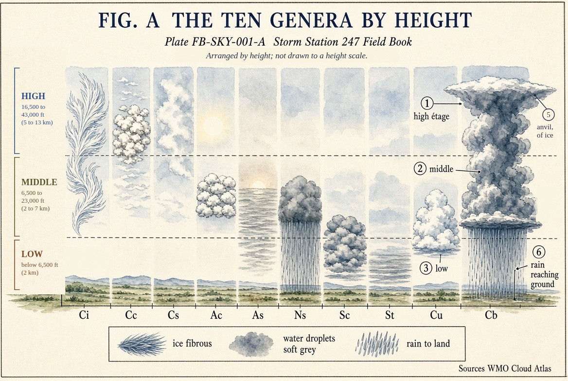
Fig. A sorts the ten by height into three levels, the étages. In the middle latitudes the low étage runs from the ground to 6,600 ft (2 km), the middle from 6,600 to 23,000 ft (2 to 7 km), and the high from 16,400 to 43,000 ft (5 to 13 km). The middle and high overlap. Cumulus and cumulonimbus have their bases in the low étage but can grow through all three, and nimbostratus, counted as a middle cloud, spreads above and below it.
What it is not
It is not a forecast. The name records the shape of a cloud and its height. A towering cumulus and a thunderstorm are different genera, but how dangerous a storm is comes from radar and the sounding, not the name.
Fog is not one of the genera. The Atlas treats it on its own, though fog that lifts off the ground is stratus.
Lookalikes
- Fog
- Cloud at the ground. The Atlas does not count it among the genera; it treats fog as a hydrometeor of its own. Fog lifting off the ground becomes stratus.
- Contrails
- Cloud made by aircraft exhaust. The Atlas names it by the genus it resembles and the word homogenitus, as cirrus homogenitus.
- Smoke and haze
- Dry particles, not water or ice. They are lithometeors, not cloud, though smoke from a large fire can build a real cumulus, a flammagenitus.
The machine
Each genus says how the air around it is moving. The layered clouds, stratus, altostratus, nimbostratus and cirrostratus, form where a broad sheet of air is lifted slowly or cooled from below; the air is stable. The heaped clouds, cumulus and cumulonimbus, form where parcels of air rise on their own; the air is unstable. The cirriform clouds are ice, high and cold, and fibrous because ice crystals fall and are drawn out by the wind.
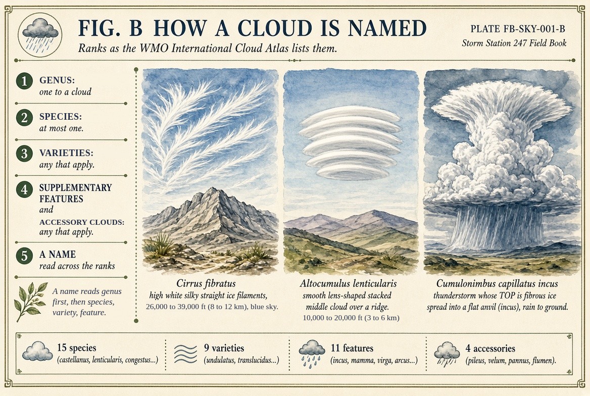
Below the genus come the species, the varieties, the supplementary features and the accessory clouds, Fig. B. A full name reads across them: cumulonimbus capillatus incus is a thunderstorm whose top has turned to fibrous ice and spread into an anvil.
The drawings
Each figure drawn as an engineering sheet, its parts numbered, to print at 11 by 17.
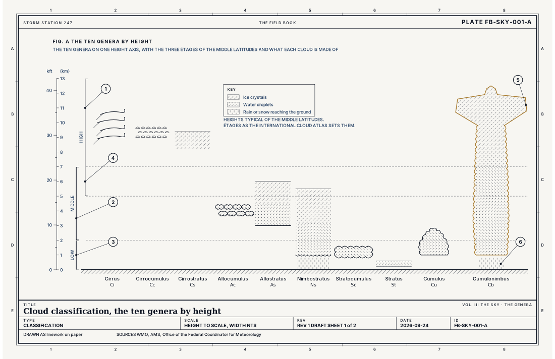
- The high étage
- The middle étage
- The low étage
- Where the middle and high étages overlap
- The anvil, spread against the tropopause
- Rain reaching the ground
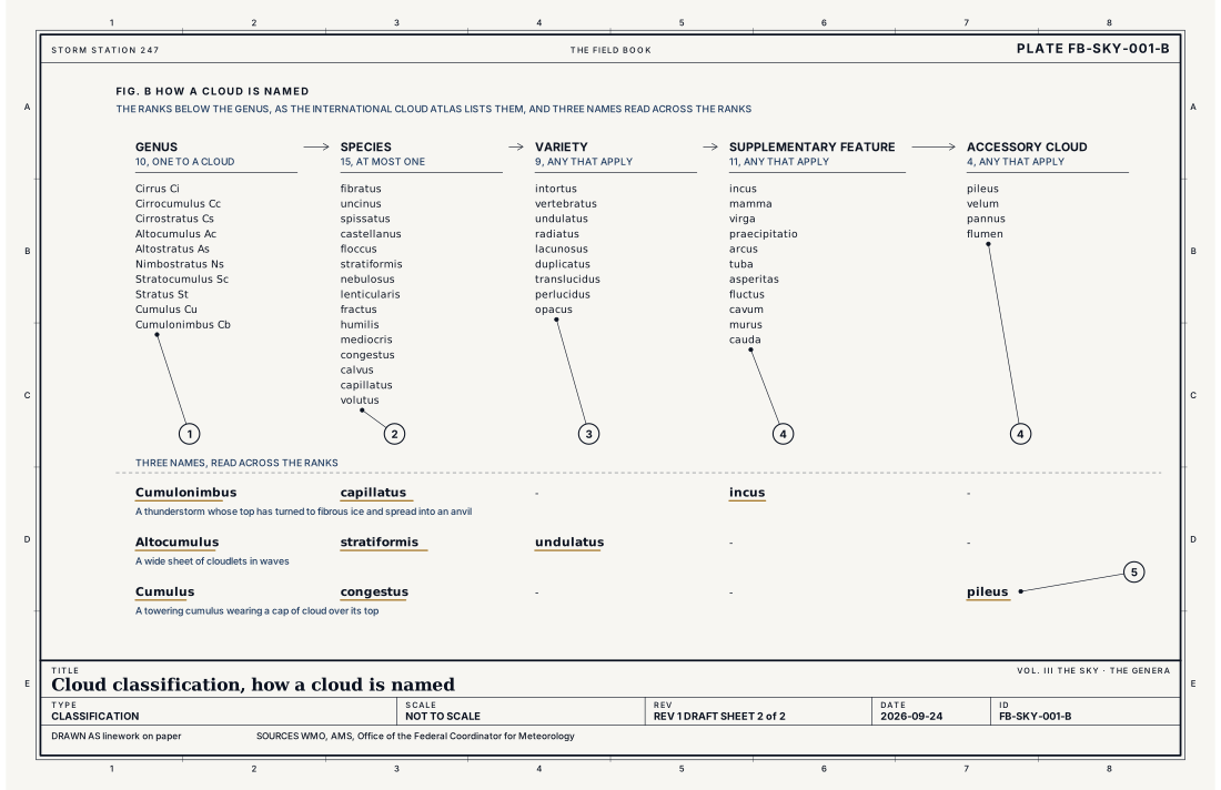
- Genus, one to a cloud
- Species, at most one
- Varieties, any that apply
- Supplementary features and accessory clouds, any that apply
- A name read across the ranks
Ingredients
- Air cooled to its dew point, mostly by rising and expanding, so its water vapour condenses on particles
- The stability of the air, which decides the shape: a broad slow lift in stable air makes a layer, parcels rising on their own in unstable air make heaps
- The temperature at the cloud's height, which decides whether it is made of water droplets, ice crystals or both
Scales
- time
- minutes for a small cumulus; hours to days for a sheet of altostratus or cirrostratus
- horizontal
- under 0.6 mi (1 km) for a cumulus; hundreds of kilometres for a stratiform sheet
- vertical
- from the ground to about 43,000 ft (13 km) in the middle latitudes, and higher at the tops of the tallest cumulonimbus
- orlanski
- meso and synoptic
Signatures
- surface
- the station's sky condition; each layer's cover and base height; CB or TCU added when a cumulonimbus or towering cumulus is seen
- satellite
- cold bright tops for high clouds and cumulonimbus in the infrared; low stratus dark in the infrared and bright in the visible
- radar
- precipitation falling from nimbostratus and cumulonimbus; most other genera show no echo
The numbers
| Quantity | Value, and the kind of number it is |
|---|---|
| Genera | 10: cirrus, cirrocumulus, cirrostratus, altocumulus, altostratus, nimbostratus, stratocumulus, stratus, cumulus and cumulonimbusStandard, International Cloud Atlas |
| Low étage | From the ground to 6,600 ft (2 km)Standard, International Cloud Atlas |
| Middle étage | 6,600 to 23,000 ft (2 to 7 km) in the middle latitudesStandard, International Cloud Atlas |
| High étage | 16,400 to 43,000 ft (5 to 13 km) in the middle latitudesStandard, International Cloud Atlas |
| Species | 15, by shape and inner structure, such as castellanus, lenticularis and congestusStandard, International Cloud Atlas |
| Varieties | 9, by arrangement and transparency, such as undulatus and translucidusStandard, International Cloud Atlas |
| Supplementary features and accessory clouds | 11 features, such as incus, mamma, virga and arcus; 4 accessory clouds: pileus, velum, pannus and flumenStandard, International Cloud Atlas |
| The four roots | Cirrus, a curl of hair; cumulus, a heap; stratus, a layer; nimbus, a rain cloud. Proposed by Luke Howard in 1803Textbook, International Cloud Atlas |
| Sky cover reported | In eighths of the sky: FEW 1 to 2, SCT 3 to 4, BKN 5 to 7, OVC 8Standard, Federal Meteorological Handbook No. 1 |
| Airport ceilometer | Cloud bases to 12,000 ft (3.7 km) overheadStandard, Automated Surface Observing System (ASOS) User's Guide |
How the station sees it
An airport station measures cloud bases directly overhead with a laser ceilometer, up to 12,000 ft, and reports each layer's cover in eighths of the sky: FEW, SCT, BKN or OVC. It does not name the genus. An observer adds CB or TCU when a cumulonimbus or a towering cumulus is in sight. The lowest layer reported as broken or overcast is the ceiling.
- Airport weather stations: the height and cover of each cloud layer overhead, to 12,000 ft
How it is warned
Clouds are not warned. One genus matters most: a cloud that makes thunder is by definition a cumulonimbus, so every severe thunderstorm warning, and nearly every tornado warning, is a warning about one, Thunderstorm FB-EVT-001.
See also
- Cirrus FB-SKY-010
- Cirrocumulus FB-SKY-011
- Cirrostratus FB-SKY-012
- Altocumulus FB-SKY-013
- Altostratus FB-SKY-014
- Nimbostratus FB-SKY-015
- Stratocumulus FB-SKY-016
- Stratus FB-SKY-017
- Cumulus FB-SKY-018
- Cumulonimbus FB-SKY-019
- Special clouds FB-SKY-034
- Orographic clouds FB-SKY-035
- Noctilucent and nacreous clouds FB-SKY-036
- Wall cloud FB-SKY-040
- Cumulonimbus architecture FB-SKY-041
- Overshooting top and above anvil plume FB-SKY-042
- Species atlas FB-SKY-030
- Varieties atlas FB-SKY-031
- Supplementary features atlas FB-SKY-032
- Accessory clouds FB-SKY-033
- Atmosphere in section FB-ENG-001
- Thunderstorm FB-EVT-001
Sources
- World Meteorological Organization. International Cloud Atlas.
- American Meteorological Society. Glossary of Meteorology.
- Office of the Federal Coordinator for Meteorology. Federal Meteorological Handbook No. 1, Surface Weather Observations and Reports.
- National Weather Service. Automated Surface Observing System (ASOS) User's Guide.
Definition after the International Cloud Atlas. Plate FB-SKY-001, revision 1, 2026-09-24. The number is permanent; cite it.