What it is
A heat wave is a run of days hotter than the place is used to. There is no one number for it: 95 °F (35 °C) is a heat wave in Seattle and an ordinary July week in Phoenix. What makes it dangerous is how long it lasts, how humid it is, and whether the nights cool off. The Weather Service counts heat as the deadliest weather in the United States, and many of its victims die indoors, in homes that never cool down.
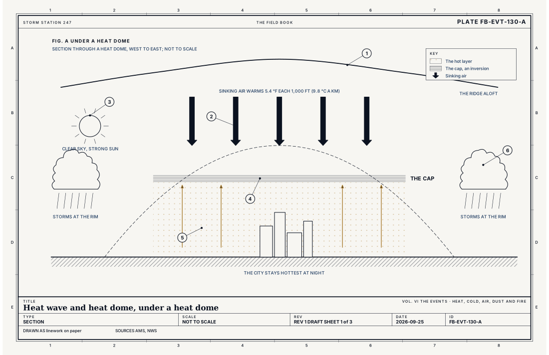
Most long heat waves have the same engine: a heat dome, a strong ridge of high pressure high in the atmosphere that settles over a region and stays. Fig. A draws one in section and Fig. B from above.
What it is not
It is not one hot afternoon. A heat wave is days of heat, and the warm nights between them are part of what makes it dangerous.
It is not a drought, though the two feed each other. A heat dome keeps the rain away, and dry ground heats faster than wet ground, because none of the sun's energy goes into evaporating water.
It is not measured by the thermometer alone. Humid air stops sweat evaporating, and the body cannot cool. The heat index below measures how hot it feels; the next plate, Extreme heat, wet bulb and WBGT FB-EVT-131, measures how much heat a body can shed at all.
Lookalikes
- A hot day
- One hot afternoon is weather; a heat wave is days of it, and the nights matter as much as the days.
- Drought
- A long lack of rain; a heat dome can cause one and dry soil can make the heat worse, but they are different events.
- Extreme heat, wet bulb
- How much heat a body can shed, measured by the wet bulb temperature and the wet bulb globe temperature: the next plate's subject.
The machine
The ridge
High above the ground, around 18,000 to 20,000 ft (5.5 to 6 km), the atmosphere has waves: troughs where the air is cool and lifting, ridges where it is warm and sinking. The jet stream runs along the boundary between them. In summer a ridge can grow strong and stall, the jet stream bent far to the north around it. Under the ridge the weather stops changing. That stalled ridge is the heat dome.
Warming by sinking
Air under the ridge sinks slowly, day after day. Sinking air is squeezed by the higher pressure below, and squeezed air warms: 5.4 °F for every 1,000 ft it sinks (9.8 °C a kilometre), the second equation below. Air that sinks 3,000 ft (914 m) arrives 16 °F (9 °C) warmer, before the sun has done anything. Sinking air is also drying air, so clouds cannot form, and the sky stays clear.
The sun, the ground and the cap
With no cloud, the long summer days put the sun's full energy onto the ground, and the ground heats the air above it. The sinking air aloft is warm too, which puts a lid on the hot layer: a capping inversion, where the temperature stops falling with height. Air heated at the ground rises only as far as the cap and no farther, so the thunderstorms that would cool a summer afternoon never form, and the heat builds day after day.
Cities make it worse. Pavement and brick soak up the day's heat and give it back all night, so a city can stay 10 °F (6 °C) or more warmer than the country around it after dark, and the people in it get no relief.
The rim
Around the edge of the dome the cap is weaker and the air can rise. Storms form there and are carried round the rim by the wind aloft, and they can be severe. Where the dome ends, so does the heat.
How hot it feels
The body cools by sweating, and sweat cools only as it evaporates. In humid air it evaporates slowly, and the body holds its heat. The heat index, the first equation below, is the Weather Service's measure of how hot the air feels in shade: at 96 °F (35.6 °C) and 55% humidity it feels like 112 °F (44.3 °C). Fig. C works the equation over a range of temperature and humidity and grades each result on the Weather Service's four levels. In full sun it can feel up to 15 °F hotter still.
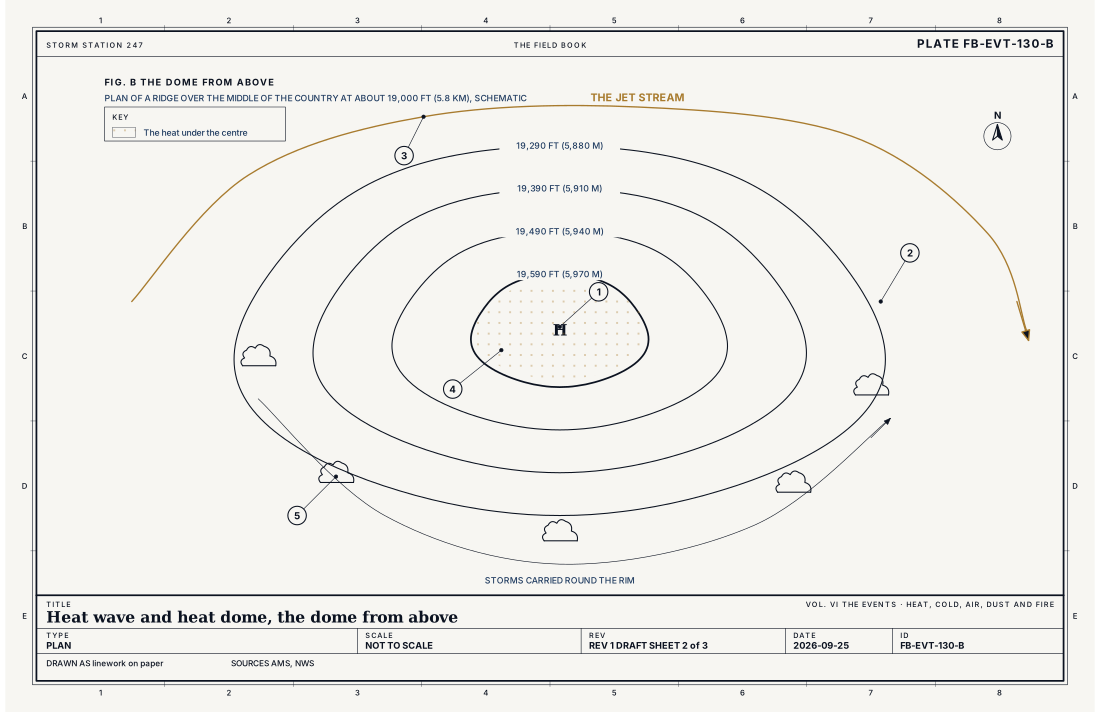
- The centre of the ridge
- Its height contours
- The jet stream, pushed north
- The heat under the centre
- Storms riding round the rim
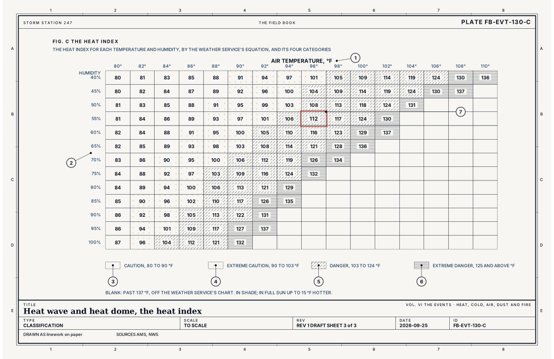
- The air temperature
- The humidity
- Caution
- Extreme caution
- Danger
- Extreme danger
- 96 °F at 55%, a heat index of 112 °F
Ingredients
- A strong ridge aloft that stays in place for days, the jet stream pushed north around it
- Air sinking under the ridge, warmed as it is squeezed, drying and clearing the sky
- Long summer days of strong sun on ground that holds the heat
- Often humid air near the ground, which keeps the nights warm and makes the heat harder on the body
Scales
- time
- several days to weeks
- horizontal
- a region hundreds to a thousand miles (hundreds to 1,600 km) across, under one ridge
- vertical
- the whole depth of the lower atmosphere, the ridge strongest near 18,000 to 20,000 ft (5.5 to 6 km)
- orlanski
- synoptic
Equations
The heat index
- the heat index, how hot it feels in shade to a person, °F
- the air temperature, °F
- the relative humidity, %
Assumes The Weather Service's fit to Steadman's model of the body, in shade and a light wind; used where the index is 80 °F or more, with small corrections at very low and very high humidity. In full sun it can feel up to 15 °F hotter.
Working form At 96 °F (35.6 °C) and 55% humidity, the heat index is 112 °F (44.3 °C): danger, on the Weather Service's chart.
Warming by sinking
- the warming of air as it sinks, °F
- the dry adiabatic lapse rate
- how far the air sinks, ft
Assumes Unsaturated air sinking without gaining or losing heat to its surroundings; air under a real ridge also loses a little heat by radiation.
Working form Air that sinks 3,000 ft (914 m) under the ridge warms by 16 °F (9 °C) on the way down, without any sun at all.
Signatures
- sounding
- warm; dry; sinking air aloft; a capping inversion at the top of the hot layer; which holds storms down
- surface
- highs well above normal for days on end; nights that stay warm; above 75 °F (24 °C) in humid places; light wind
- satellite
- clear skies under the ridge; a ring of storms around its edge
- radar
- little or nothing under the dome; storms along its rim; where they move round it with the wind
The numbers
| Quantity | Value, and the kind of number it is |
|---|---|
| Heat wave | A period of abnormally and uncomfortably hot, and usually humid, weather, lasting at least a day and conventionally several daysStandard, Glossary of Meteorology |
| Heat Advisory | A heat index high enough to be dangerous, set by each office for its climate; commonly around 105 °F (41 °C) in much of the countryTypical, Directive 10-515 |
| Extreme Heat Warning | A heat index higher and longer lasting, set by each office; commonly around 110 °F (43 °C) in much of the countryTypical, Directive 10-515 |
| Heat index categories | Caution 80 to 90 °F (27 to 32 °C); extreme caution 90 to 103 °F (32 to 39 °C); danger 103 to 124 °F (39 to 51 °C); extreme danger 125 °F (52 °C) and aboveStandard, The Heat Index Equation (the Rothfusz regression |
| Dry adiabatic lapse rate | 5.4 °F per 1,000 ft (9.8 °C per km)Standard, Glossary of Meteorology |
How the station sees it
Airport stations report the temperature and the dew point every minute, and the heat index is worked from them. Cooperative observers keep the long daily record of highs and lows that a heat wave is judged against, and the lowest temperature of each night is watched as closely as the highest of each day. Road weather stations add the air temperature along the highways between the airports, where the heat can differ by several degrees.
A standard station measures the air in shade, in a shield at a fixed height over grass, Stevenson screen and siting FB-INS-009. The heat on a sunny parking lot, or in an upstairs room, is higher than any station reports.
- Airport weather stations: the temperature and the dew point every minute, from which the heat index is worked
- Cooperative observers: the day's high and low, the long record a heat wave is judged against
- Road weather stations: the air temperature along the highways, between the airports, where the heat differs
How it is warned
Each Weather Service office sets its own heat criteria for its climate. A Heat Advisory is issued when the heat index is expected to be dangerous, commonly around 105 °F (41 °C) in much of the country. An Extreme Heat Watch is issued a day or more ahead of worse heat, and an Extreme Heat Warning when it is expected, commonly around a heat index of 110 °F (43 °C).
In a heat wave, drink water before you are thirsty, stay in air conditioning in the hottest hours, and check on anyone old, sick or alone. Never leave a child or a pet in a parked car, even for minutes.
| VTEC | Phenomenon | The alerts that carry it |
|---|---|---|
HT | heat | Heat Advisory |
XH | extreme heat | Extreme Heat Warning; Extreme Heat Watch |
See also
- Extreme heat, wet bulb and WBGT FB-EVT-131
- Air stagnation FB-EVT-134
- Fire weather FB-EVT-139
- Stevenson screen and siting FB-INS-009
- How to read a warning FB-STN-001
Sources
- American Meteorological Society. Glossary of Meteorology.
- National Weather Service. Directive 10-515, WFO Non-Precipitation Weather Products Specification.
- National Weather Service. The Heat Index Equation (the Rothfusz regression, 1990) and the heat index chart.
- National Weather Service. Watch, Warning, Advisory definitions.
Definition after the Glossary of Meteorology. Plate FB-EVT-130, revision 1, 2026-09-25. The number is permanent; cite it.