What it is
A winter storm is a storm of snow, sleet or freezing rain heavy enough to be dangerous, or of several of them together: the snow that closes roads and schools, the sleet that piles up on them, the freezing rain that glazes everything it touches. Most come from large storm systems, which draw moist air into the cold, over hundreds of miles and a day or two.
The Weather Service warns it with a Winter Storm Warning when the snow, sleet or ice of one event is expected to reach the office's own criteria. It watches for it with a Winter Storm Watch when such a storm is possible, and advises with a Winter Weather Advisory when the snow or ice will fall short of the warning but still cause trouble. The criteria are each office's own, because the snow that is ordinary in one place is a danger in another: 1 in (2.5 cm) in one event across the far South, 6 in (15 cm) across much of the country, 12 in (30 cm) in the western mountains, and 18 in (46 cm) in Utah's Wasatch Mountains. Fig. B draws every zone.
What it is not
It is not a blizzard, Blizzard FB-EVT-081, which is warned for the wind and the visibility, whatever the amount; a blizzard can come with little new snow at all.
It is not an ice storm, Ice storm FB-EVT-084, warned for the ice that freezing rain builds on wires and trees, though a winter storm can bring some ice with its snow.
It is not lake effect snow, Lake effect snow FB-EVT-082, or a snow squall, Snow squall FB-EVT-086, both narrower and shorter. No Snow Squall Warning is issued while a Winter Storm Warning is in force.
Lookalikes
- Blizzard
- Wind and snow cutting the visibility under a quarter mile for three hours or longer, Blizzard FB-EVT-081, warned for the wind and the visibility, not the amount.
- Ice storm
- Freezing rain building ice on everything it touches, Ice storm FB-EVT-084, warned for the ice.
- Lake effect snow
- Narrow bands of snow off a lake, Lake effect snow FB-EVT-082, often under fair skies elsewhere.
- Snow squall
- A burst of snow and wind that passes in under an hour, Snow squall FB-EVT-086; no Snow Squall Warning is issued during a Winter Storm Warning.
Machine
Moisture drawn into the cold
A winter storm needs moisture and cold air at once. A large storm system supplies both: its winds draw moist air from the south up and over the cold air on its northern and western side, and the air, lifted along the storm's fronts, cools and drops its moisture as snow. The heaviest snow falls in bands within the broad shield of snow, often well to the cold side of the storm's center, Midlatitude cyclone life cycle FB-EVT-060.
What reaches the ground
Snow forms in the cloud. Whether it reaches the ground as snow depends on the air below. If the air is below freezing all the way down, it falls as snow. If it falls through a warm layer it melts; then, if the cold air beneath is deep enough, it refreezes as sleet, and if not, it lands as rain that freezes on contact, freezing rain. One storm can bring all three in bands from north to south, and change from one to another as the warm air advances.
Deciding on a range
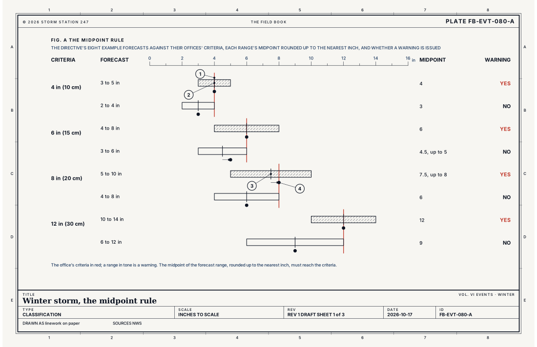
A forecast of snow is a range, such as 8 to 12 inches, because the amount is uncertain. The directive decides warnings and advisories on the middle of that range, rounded up to the nearest inch, against the office's criteria; the equation below gives the rule. Fig. A draws the directive's own eight examples: with criteria of 8 in (20 cm), a forecast of 5 to 10 in earns a warning, its midpoint of 7.5 rounding up to 8, and a forecast of 4 to 8 in does not.
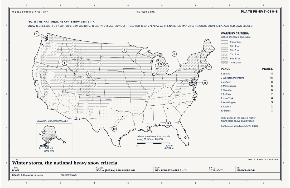
- Seattle, 4 in (10 cm)
- Wasatch Mountains, Utah, 18 in (46 cm)
- Denver, 8 in (20 cm)
- Minneapolis, 6 in (15 cm)
- Chicago, 6 in (15 cm)
- Buffalo, 7 in (18 cm)
- New York, 6 in (15 cm)
- Washington, 5 in (13 cm)
- Atlanta, 2 in (5 cm)
- Dallas, 3 in (8 cm)
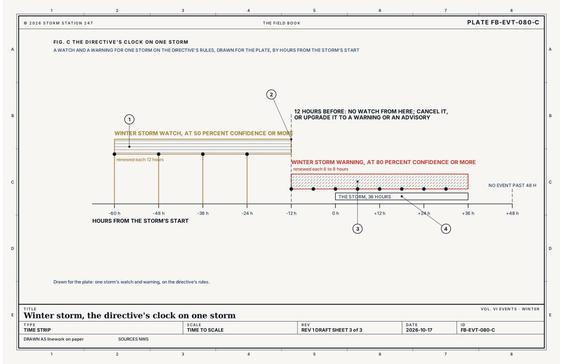
- The watch, at 50 percent confidence or more
- Twelve hours before the start, the watch upgraded or cancelled
- The warning, at 80 percent confidence or more
- The storm, within 48 hours
Ingredients
- A storm system drawing moisture into cold air
- Air cold enough, from the cloud to the ground, for the snow to reach the ground as snow
- Where a warm layer lies above cold air near the ground, sleet or freezing rain instead
- Lift along the storm's fronts to wring the moisture out
Scales
- time
- hours to two days; an event is set by its office and runs no longer than 48 hours unless absolutely necessary
- horizontal
- hundreds of miles, across the cold side of a large storm system
- vertical
- the depth of the storm's clouds, several miles, and the layers of warm and cold air that decide what falls
- orlanski
- meso-alpha to synoptic
Equations
The midpoint rule
- the low and high ends of the forecast range of snow or sleet, in
- the office's warning or advisory criteria, in
Assumes Warnings and advisories for snow and sleet are decided on the average of the forecast range, rounded up to the nearest inch, against the office's criteria. The forecast is said as a range, such as 8 to 12 inches, or, where it is very uncertain, as up to 12 inches or 8 inches or more.
Working form With criteria of 8 in (20 cm), a forecast of 5 to 10 in (13 to 25 cm) has a midpoint of 7.5 in, rounded up to 8: a warning. A forecast of 4 to 8 in (10 to 20 cm) has a midpoint of 6: no warning. With criteria of 6 in (15 cm), 3 to 6 in has a midpoint of 4.5, rounded up to 5: no warning.
Signatures
- surface
- the pressure falling as the storm nears; the wind from the east or north ahead of it; snow beginning; often heavy for hours
- satellite
- a large comma of cloud around the storm; its head over the cold air
- radar
- broad areas of snow; with heavier bands within them; a bright band where snow melts into rain
- sounding
- the temperature below freezing from the cloud to the ground for snow; a warm layer aloft over cold air for sleet or freezing rain
Numbers
| Quantity | Value, and the kind of number it is |
|---|---|
| Winter Storm Warning | Snow, lake effect snow where a region chooses, ice or sleet meeting the office's event criteria; or a combination with at least one of them meeting its criteria; or a storm forecast to have high impact though it will not meet the criteriaStandard, Directive 10-513 |
| Winter Storm Watch | Conditions favorable for a winter weather event to meet or exceed the office's event Winter Storm Warning criteriaStandard, Directive 10-513 |
| Winter Weather Advisory | One or more winter hazards meeting the office's 12 or 24 hour advisory criteria but not the warning's, or based on impactStandard, Directive 10-513 |
| When a watch is issued | At 50 percent confidence or more that the event will meet the warning criteria, with as much lead time as possible; not within 12 hours of the startStandard, Directive 10-513 |
| When a warning or advisory is issued | At 80 percent confidence or more, when the weather is occurring, imminent or highly likelyStandard, Directive 10-513 |
| How often they are renewed | A watch at least every 12 hours; a warning or advisory at least every 6 to 8 hoursStandard, Directive 10-513 |
| Impact-based criteria | A warning may be issued for less snow than the criteria early in the season, or at a critical time such as rush hourStandard, Directive 10-513 |
| How long an event runs | Set by the office, and not over 48 hours unless absolutely necessaryStandard, Directive 10-513 |
| From one zone to the next | The criteria change by no more than 1 in (2.5 cm), except where elevation or climate requiresStandard, Directive 10-513 |
| Warning criteria in the lower 48 | From 1 in (2.5 cm) of snow in one event, across the far South from Texas to Georgia and Florida and in parts of Arizona and California, to 12 in (30 cm) in the western mountains and 18 in (46 cm) in Utah's Wasatch MountainsStandard, Winter Storm Warning Criteria for Heavy Snow |
| The most common criteria | 6 in (15 cm), in 1,072 of the 3,850 zones of the lower 48Standard, Winter Storm Warning Criteria for Heavy Snow |
| Higher ground | In 80 zones a higher figure above an elevation, such as 8 in (20 cm) above 5,000 ft (1,524 m) in northern ArizonaStandard, Winter Storm Warning Criteria for Heavy Snow |
| Warning criteria in Alaska | From 6 to 24 in (15 to 61 cm)Standard, Winter Storm Warning Criteria for Heavy Snow |
How the station sees it
The cooperative observers measure the snowfall and the depth on the ground once a day, and the airport stations report the temperature, the wind and the weather falling every minute. Where a Winter Storm Warning, Watch or Winter Weather Advisory is in force, the places it covers carry it, and each alert has its own report.
- Cooperative observers: the snowfall and the depth on the ground once a day
- Airport weather stations: the temperature, the wind and the weather falling, every minute
- Severe Alerts: every Winter Storm Warning and Watch and Winter Weather Advisory in force, each with its own report
How it is warned
A Winter Storm Watch is issued, with as much lead time as possible, when there is a 50 percent chance or more that a storm will meet the warning criteria; it is renewed at least every 12 hours. It is not issued within 12 hours of the storm's start: by then the office cancels it or turns it into a warning or an advisory. A Winter Storm Warning or a Winter Weather Advisory is issued when the confidence reaches 80 percent or more, when the weather is occurring, imminent or highly likely, and is renewed at least every 6 to 8 hours until the storm ends. Fig. C draws the clock on one storm.
A warning can be issued for one kind of weather, such as heavy snow or ice; for a mix in which at least one meets its criteria; or for a storm that will fall short of the criteria but strike at a bad time, early in the season or in the rush hour. Each event is set by the office and runs no longer than 48 hours unless absolutely necessary. Across the lower 48, the criteria change by no more than an inch from one zone to the next, except where elevation or climate requires; in 80 zones of the West a higher figure holds above a stated elevation.
A Winter Storm Warning for heavy snow means the snow will make travel dangerous: travel only in an emergency, and if you must, keep an extra flashlight, food and water in the vehicle.
| VTEC | Phenomenon | The alerts that carry it |
|---|---|---|
WS | winter storm | Winter Storm Warning; Winter Storm Watch |
WW | winter weather | Winter Weather Advisory |
See also
- Blizzard FB-EVT-081
- Ice storm FB-EVT-084
- Lake effect snow FB-EVT-082
- Snow squall FB-EVT-086
- Midlatitude cyclone life cycle FB-EVT-060
- How to read a warning FB-STN-001
Sources
- National Weather Service. Directive 10-513, WFO Winter Weather Products Specification.
- National Weather Service. Winter Storm Warning Criteria for Heavy Snow, Directive 10-513 Appendix D.
Definition after the Directive 10-513, WFO Winter Weather Products Specification. Plate FB-EVT-080, revision 1, 2026-10-17. The number is permanent; cite it.