What it is
A nor'easter is a strong storm that forms or deepens along the East Coast and travels up it, its centre just offshore. It takes its name from the wind: north of the storm, along the coast, the wind blows hard from the northeast, off the ocean and onto the land. Nor'easters can come at any time of year, but they are most frequent and strongest from September to April, when the contrast between the cold land and the warm sea is greatest.
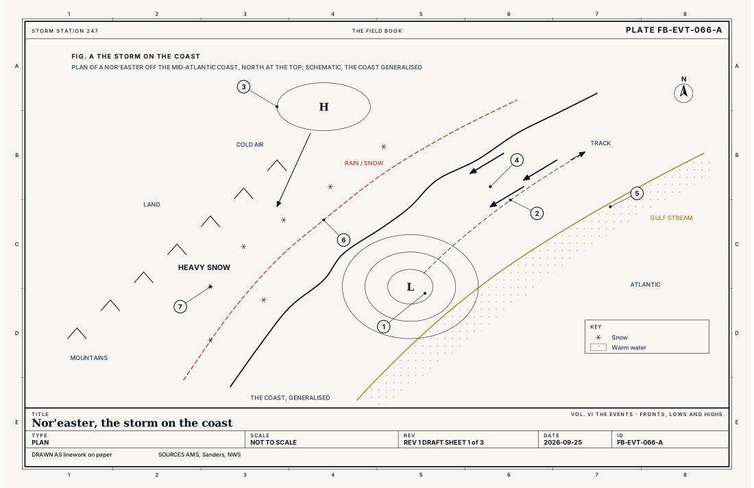
One nor'easter can bring several hazards at once: heavy snow inland, rain and wind on the coast, and water piled against the shore that floods coastal streets and eats away beaches. Fig. A draws a storm in plan and Fig. B across the coast.
What it is not
It is not a hurricane. A hurricane is a warm core storm fed by warm tropical water, and it has no fronts. A nor'easter is a cold season storm of the middle latitudes, Midlatitude cyclone life cycle FB-EVT-060, with fronts and cold air aloft. A hurricane that moves up the coast in the fall can turn into one, and some of the worst storms in the Northeast have been both.
It is not a blizzard, though it can bring one. A blizzard is a set of conditions, wind and blowing snow cutting the visibility, Blizzard FB-EVT-081; many nor'easters bring heavy snow without them, or rain.
It is not an Alberta clipper, the small, fast storm from Canada that brings a few inches of snow and little else.
Lookalikes
- Hurricane
- A warm core storm fed by warm water, strongest in late summer and fall; a nor'easter is a cold season storm with fronts and a cold core aloft.
- Alberta clipper
- A fast low from Canada with little moisture and light snow; a nor'easter draws on the Atlantic and can bury the coast.
- Blizzard
- A set of conditions, wind and snow and visibility, that a nor'easter can bring; many nor'easters are not blizzards.
The machine
Where it forms
In winter the land is cold and the Gulf Stream offshore stays warm. Along the coast, between them, the temperature changes sharply over a short distance, and that sharp contrast is where storms can grow. When a trough in the jet stream moves in from the west and its lifting air arrives over the coast, a low forms or strengthens there, often off the Carolinas or the Virginia capes, and moves northeast, parallel to the coast.
Cold air held against the mountains
To the north a high over eastern Canada feeds cold, dry air south. East of the Appalachians that cold air is trapped at the ground, dammed against the mountains, and it drains down the coastal plain as a shallow wedge. The storm's warm, moist air from the ocean rides up and over the wedge. Fig. B draws the section: inland, where the cold wedge is deep, the precipitation falls as snow; on the coast, where the ocean air reaches the ground, it falls as rain. Between them lies a band of sleet and freezing rain, and the line where rain turns to snow runs roughly parallel to the coast. A shift of a few tens of miles in the storm's track moves that line across the big cities.
The snow bands
The snow does not fall evenly. The heaviest often comes in narrow bands on the storm's northwest side, where the air is lifted hardest, and one town can measure twice the snow of the next. Under the strongest bands snow falls at one to three inches (2.5 to 7.5 cm) an hour, sometimes with thunder, Thundersnow FB-EVT-087.
Why it deepens so fast
Nor'easters often strengthen very quickly. A low whose central pressure falls fast enough is called a bomb, and the first equation below gives the threshold: 24 mb in 24 hours at latitude 60°, less nearer the equator, 17.8 mb at 40°. A nor'easter off the coast that falls from 1,000 to 972 mb in a day, 28 mb, is a bomb, Bombogenesis FB-EVT-067. Fig. C draws the threshold against latitude.
The wind and the water
The deeper the low, the harder the wind, High wind FB-EVT-150, and north of the low it blows onshore for hours, sometimes days. It piles water against the coast, and the low's pressure lifts the sea as well: the second equation below gives about 0.39 in (1 cm) for each millibar, about 17 in (43 cm) under a low of 970 mb, before the wind adds its larger share. Waves ride on top of the raised water. A slow storm that lasts through several high tides does the most damage, and a storm at the spring tides of a new or full moon adds more, Moon and tides FB-CLK-003, Coastal flood FB-EVT-105.
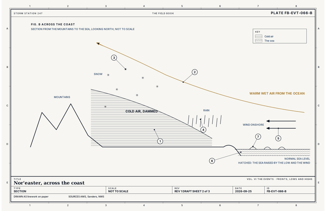
- Cold air at the ground, inland
- Warm air from the ocean, riding over it
- Snow inland
- Rain on the coast
- The wind, onshore
- The sea raised against the coast
- Waves on the raised water
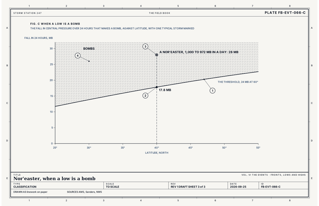
- The threshold
- Latitude 40°, 17.8 mb
- A nor'easter falling 28 mb in a day
- Bombs, above the curve
Ingredients
- A low forming along the coast, where cold air over the land meets warm air over the Gulf Stream
- A trough aloft moving in from the west, lifting the air over the low and deepening it
- A cold high to the north, feeding cold air down the coast and inland, east of the mountains
- Moisture from the Atlantic, carried round the low and over the cold air on its north and west side
Scales
- time
- one to three days, from the first rain or snow to the last
- horizontal
- a storm several hundred to a thousand miles (several hundred to 1,600 km) across, along the coast from the Carolinas to Maine and Atlantic Canada
- vertical
- the whole depth of the lower atmosphere, a deep low under a trough aloft
- orlanski
- synoptic
Equations
The bomb threshold
- the fall in central pressure over 24 hours that makes a low a bomb, mb
- the latitude of the low
Assumes A rule of thumb, not a law of physics; it scales a fall of 24 mb in a day at 60° to the latitude of the storm, because the same pressure gradient means a stronger wind nearer the equator.
Working form At latitude 40° the threshold is 17.8 mb in 24 hours; a nor'easter off the coast that falls from 1,000 to 972 mb in a day, 28 mb, is a bomb.
The sea under the low
- how much the sea rises under low pressure, m
- how far the pressure is below normal, Pa
- the density of sea water, 1,025 kg m⁻³
- gravity, 9.81 m s⁻²
Assumes The inverse barometer effect in still water with time to adjust; the wind piling water onto the coast usually adds far more.
Working form Each millibar of fall raises the sea about 0.39 in (1 cm); under a low of 970 mb, 43 mb below the standard 1,013 mb, the sea stands about 17 in (43 cm) higher before the wind adds its share.
Signatures
- sounding
- inland; a wedge of cold air at the ground under warm air from the ocean; on the coast; the warm air reaching the ground
- surface
- pressure falling fast offshore; the wind backing to the northeast along the coast and rising; temperatures near freezing in the band where rain turns to snow
- satellite
- a comma cloud off the coast; its head wrapped round the low's north and west side
- radar
- heavy bands of snow on the storm's northwest side; rain along the coast
The numbers
| Quantity | Value, and the kind of number it is |
|---|---|
| Nor'easter | A cyclone along the east coast of North America whose strongest winds blow from the northeast, onto the coastStandard, Glossary of Meteorology |
| Bomb | A low whose central pressure falls at least 24 mb in 24 hours at 60°, scaled by the sine of its latitudeTextbook, Sanders 1980 |
| Inverse barometer effect | The sea surface rises about 0.39 in (1 cm) for each millibar the air pressure fallsStandard, Glossary of Meteorology |
| Season | At any time of year, but most frequent and strongest from September to AprilStandard, Glossary of Meteorology |
How the station sees it
Airport stations on the coast show the storm coming: the pressure falling fast, the wind backing to the northeast and rising, the rain or snow arriving. Tide and river gauges along the coast show the water rising above the tide that was predicted, the surge, hour by hour. Inland, cooperative observers measure the snow each morning, and their records show how sharply the snow totals change across the rain and snow line.
- Airport weather stations: the falling pressure, the northeast wind and the rain or snow, minute by minute
- River and tide gauges: the water rising at the coast, against the tide it would have had
- Cooperative observers: the snowfall and the depth inland, measured once a day
How it is warned
There is no nor'easter warning. The Weather Service warns of what the storm will do: a Winter Storm Warning or a Blizzard Warning for the snow, a High Wind Warning for the wind, and a Coastal Flood Warning for the water. One storm often brings several at once, to different places.
In a nor'easter, follow the warnings for your own place: move cars and belongings away from low coastal streets before the high tide, stay off the roads in the snow, and keep supplies for several days without power.
| VTEC | Phenomenon | The alerts that carry it |
|---|---|---|
CF | coastal flood | Coastal Flood Advisory; Coastal Flood Statement; Coastal Flood Warning; Coastal Flood Watch |
See also
- Midlatitude cyclone life cycle FB-EVT-060
- Bombogenesis FB-EVT-067
- Blizzard FB-EVT-081
- Coastal flood FB-EVT-105
- High wind FB-EVT-150
- Moon and tides FB-CLK-003
Sources
- American Meteorological Society. Glossary of Meteorology.
- Sanders, F. and J. R. Gyakum. Synoptic-Dynamic Climatology of the "Bomb", Monthly Weather Review 108 (1980).
- National Weather Service. Watch, Warning, Advisory definitions.
Definition after the Glossary of Meteorology. Plate FB-EVT-066, revision 1, 2026-09-25. The number is permanent; cite it.