What it is
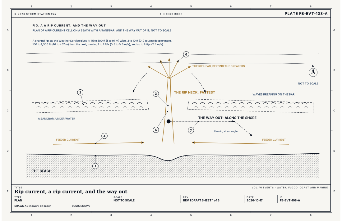
A rip current is a strong, narrow flow of water running out to sea, from close to the shore, through the breaking waves and beyond them. It is found on almost any beach with breaking waves, on the ocean, the Gulf and the Great Lakes alike, and it is the leading danger at such a beach: tens of thousands of people are rescued from rip currents by lifeguards each year in the United States, and more than 100 drown.
A typical rip moves 1 to 2 ft (0.3 to 0.6 m) a second, and the strongest up to 8 ft (2.4 m) a second, as fast as the fastest swimmers. It does not pull anyone under. It carries a swimmer away from the shore, and the danger is what follows: a swimmer who tries to swim straight back against it tires, and panics.
What it is not
It is not a rip tide. A tide is the slow rise and fall of the sea over hours. The strong flows in inlets, estuary mouths and harbors as the tide comes in and goes out are tidal currents, sometimes called rip tides; a rip current is a different thing, driven by the waves.
It is not undertow. Water carried toward the beach by breaking waves also returns slowly along the bottom; that is undertow, and it is usually too slow to be a danger. Neither pulls a person under the water.
It is not high surf, High surf FB-EVT-107, though the two often come together, nor the wider set of dangers on Beach hazards FB-EVT-109.
Lookalikes
- A tidal current
- The strong flow in an inlet, an estuary's mouth or a harbor as the tide comes in and goes out. It is sometimes called a rip tide; a rip current is not a tide at all.
- Undertow
- The slow return of water seaward along the bottom. Neither undertow nor a rip current pulls a person under; the feeling of being pulled under comes from panic, tiredness and breaking waves.
- High surf
- Large waves breaking on or near the shore, High surf FB-EVT-107. High surf often brings rip currents with it, and its advisory or warning may then name them too.
- Beach hazards
- Several dangers at once, longshore currents, rough surf, cold water, Beach hazards FB-EVT-109.
Machine
The water stands higher where waves break harder
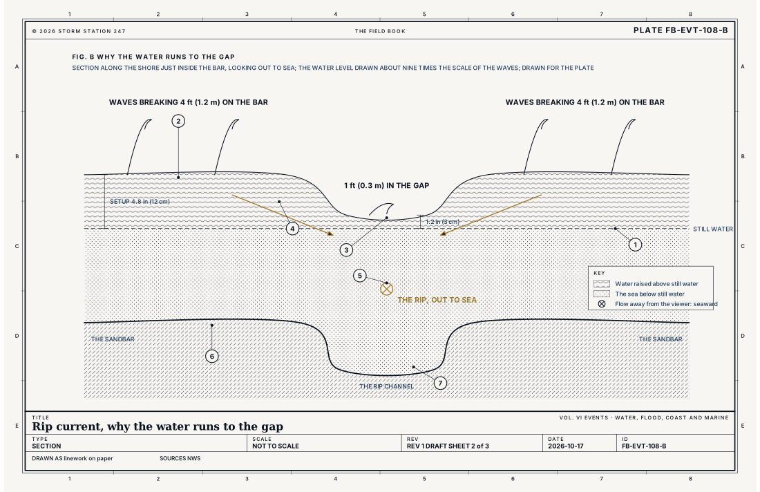
When a wave breaks, it pushes water toward the shore and raises the average water level there a little, by about a tenth of the breaking wave's height. This is wave setup, too small to see by eye. Along a beach with a sandbar, the waves break hard on the bar and hardly at all over a gap in it. Behind the bar the water stands higher; in the gap, lower. Fig. B draws it: waves breaking 4 ft (1.2 m) on the bar raise the water about 4.8 in (12 cm), and waves of 1 ft (0.3 m) in the gap about 1.2 in (3 cm). The water runs downhill, along the shore, from the higher water toward the gap.
Feeders, neck and head
Fig. A draws the whole cell. Feeder currents run along the shore from both sides and meet at the gap. There they turn out to sea as the rip neck, a narrow, fast flow through the gap, fastest about halfway out and just below the surface. Past the breakers the flow slows and spreads into the rip head, and the waves carry much of the water back toward the beach over the bar. A rip held in a channel through a bar is called a channel rip; it can stay in one place for days, weeks or months.
Other rips
Rips also form beside piers, jetties, groins and headlands, where the waves are sheltered on one side or a current along the shore is turned out to sea, even when the waves are small. On a straight beach with no bar, waves from two directions can break unevenly and make flash rips that last a few minutes and cannot be foretold to the place.
Pulses and the tide
A rip's flow is not steady. When a group of larger waves breaks, the setup jumps, waders lose their footing, and the rip can more than double its speed for 30 seconds to a minute: a pulse. The tide matters too. On a beach with a tide range under 6 ft (1.8 m), rips run fastest an hour or two either side of low tide, when the waves break hardest on the bar, and may stop near high tide. Whether the tide is rising or falling does not matter, only its level.
- Still water
- The water raised behind the bar, 4.8 in (12 cm)
- The water lower in the gap, 1.2 in (3 cm)
- The flow along the shore, downhill
- The rip, out to sea
- The sandbar
- The rip channel
- The risk, in the Surf Zone Forecast
- A Rip Current Statement
- A Beach Hazards Statement
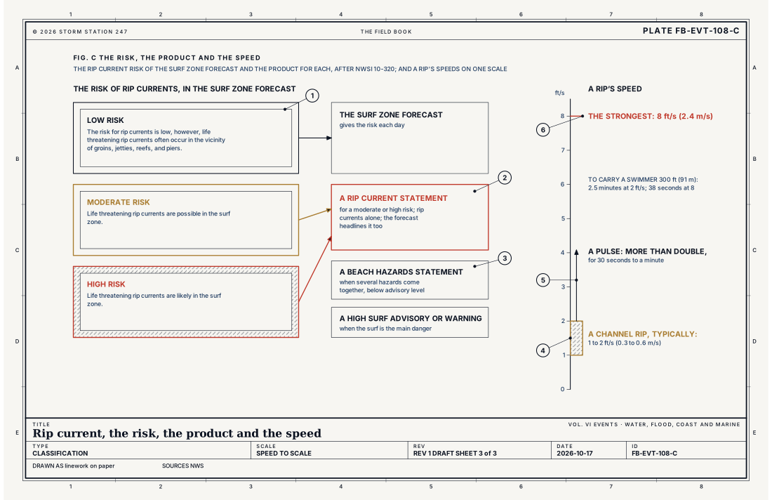
- A typical channel rip, 1 to 2 ft/s (0.3 to 0.6 m/s)
- A pulse, more than double
- The strongest, 8 ft/s (2.4 m/s)
Ingredients
- Breaking waves, on any ocean, sea or lake shore
- Waves breaking harder in some places along the beach than in others: on a sandbar beside a gap, against a pier or jetty, or where wave trains cross
- A sandbar with a channel through it, or a groin, jetty, pier or reef
- Low tide on many beaches, when the waves break hardest on the bar
Scales
- time
- minutes for a flash rip; days to months for a rip held in a channel
- horizontal
- 15 to 300 ft (5 to 91 m) wide, from the shore out past the breakers
- vertical
- a channel 3 to 10 ft (0.9 to 3 m) deep or more; the water raised a few inches by the breaking waves
- orlanski
- micro-beta to micro-alpha
Equations
Wave setup
- the rise of the average water level near the shore, ft
- the height of the breaking waves, ft
Assumes The Weather Service's rule of thumb, about a tenth of the breaking height; the true share depends on the slope of the beach and the waves. Where waves break unevenly along the shore, the water stands higher behind the harder breaking, and that difference in level drives the flow along the shore to where the water stands lower, and out.
Working form Waves breaking 4 ft (1.2 m) high on a sandbar raise the water behind it about 4.8 in (12 cm); waves of 1 ft (0.3 m) in the gap beside it, about 1.2 in (3 cm). The water stands 3.6 in (9 cm) higher behind the bar, and runs along the shore, downhill, to the gap and out through it.
Signatures
- surface
- a gap in the line of breaking waves; a narrow path of darker water; choppy; rippled water heading out; foam or sand carried past the breakers; scalloped bays cut in the beach
- satellite
- nothing; a rip is far too small
- radar
- nothing; a rip is water; not rain
- sounding
- nothing; the cause is the waves; from swell made by a storm far away or wind nearby
Numbers
| Quantity | Value, and the kind of number it is |
|---|---|
| Low Risk | The risk for rip currents is low, however, life threatening rip currents often occur in the vicinity of groins, jetties, reefs, and piersStandard, Directive 10-320 |
| Moderate Risk | Life threatening rip currents are possible in the surf zoneStandard, Directive 10-320 |
| High Risk | Life threatening rip currents are likely in the surf zoneStandard, Directive 10-320 |
| Rip Current Statement | Issued to highlight a moderate or high risk, with rip current information alone, in seasons each office sets with its regionStandard, Directive 10-320 |
| Beach Hazards Statement | Several beach and surf zone hazards below advisory criteria, such as dangerous currents, unusually cold water or lightning at the beachStandard, Directive 10-320 |
| Speed | 1 to 2 ft/s (0.3 to 0.6 m/s) in a typical channel rip; up to 8 ft/s (2.4 m/s)Typical, Rip Current Science |
| A rip pulse | More than double the speed, for 30 seconds to a minute, as a group of larger waves breaksTypical, Rip Current Science |
| A channel rip | 15 to 300 ft (5 to 91 m) wide, 3 to 10 ft (0.9 to 3 m) deep or more, 150 to 1,500 ft (46 to 457 m) from the nextTypical, Rip Current Science |
| Wave setup | About a tenth of the breaking wave heightTypical, Rip Current Science |
| The tide | On beaches with a tide range under 6 ft (1.8 m), rips run fastest an hour or two either side of low tide, and may stop near high tideTypical, Rip Current Science |
| The breaker zone | Waves begin to break in water about 10 to 20 ft (3 to 6 m) deepTypical, Rip Current Science |
| The toll | Tens of thousands of rescues by lifeguards and over 100 drownings a year in the United StatesTypical, NOAA and USLA Rip Current Safety Toolkit |
| At a beach with lifeguards | The chance of drowning is 1 in 18 millionTypical, How to Avoid Getting Caught in a Rip Current |
| If caught | Relax and float. Don't swim against the current. If able, swim in a direction following the shoreline. If unable to escape, face the shore and call or wave for helpStandard, Directive 10-320 |
How the station sees it
No instrument on this site measures a rip current; the Weather Service forecasts the risk. Each beach on this site carries its rip current or swim risk for the day from the Surf Zone Forecast, the waves at its nearest buoy, their height, period and direction, and the tide. The signs at the beach are a gap in the line of breaking waves, a narrow path of darker water, choppy water heading out, and foam or sand carried past the breakers; they are easiest to see from a dune or a beach access above.
- Beaches: every beach, with its rip current or swim risk today, the waves at its nearest buoy and the tide
- Severe Alerts: every Rip Current Statement and Beach Hazards Statement in force, each with its own report
How it is warned
The Surf Zone Forecast gives the risk of rip currents for each day in three steps, in the Weather Service's own words: a low risk, though life threatening rip currents often occur near groins, jetties, reefs and piers; a moderate risk, when life threatening rip currents are possible in the surf zone; and a high risk, when they are likely. A moderate or high risk is headlined, and a Rip Current Statement is issued for it, in the seasons each office sets. A Beach Hazards Statement covers several dangers together, and a High Surf Advisory or Warning covers the surf when it is the main danger. Fig. C sets them out.
Swim at a beach with lifeguards, where the chance of drowning is 1 in 18 million. If caught in a rip current, relax and float. Don't swim against the current. If able, swim in a direction following the shoreline. If unable to escape, face the shore and call or wave for help.
| VTEC | Phenomenon | The alerts that carry it |
|---|---|---|
RP | rip current | Rip Current Statement |
See also
- High surf FB-EVT-107
- Beach hazards FB-EVT-109
- Coastal flood FB-EVT-105
- Waves and swell FB-WAT-041
- Tide as a water machine FB-WAT-042
- Moon and tides FB-CLK-003
- How to read a warning FB-STN-001
Sources
- National Weather Service. Rip Current Science.
- National Weather Service. Directive 10-320, Surf Zone Forecast and Coastal/Lakeshore Hazard Services.
- National Weather Service. NOAA and USLA Rip Current Safety Toolkit.
- National Weather Service. How to Avoid Getting Caught in a Rip Current.
Definition after the Rip Current Science. Plate FB-EVT-108, revision 1, 2026-10-17. The number is permanent; cite it.