What it is
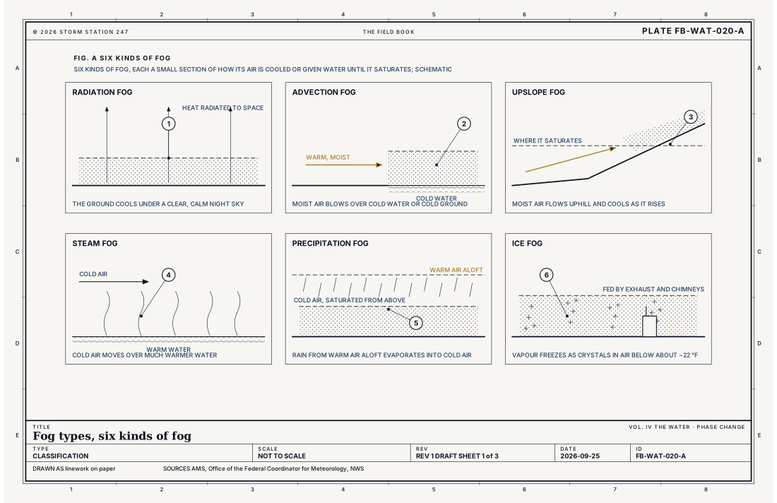
Fog is cloud at the ground: drops of water, or ice crystals, dense enough to cut the visibility below 5/8 of a mile (1 km). It forms in one of two ways. The air near the ground is cooled to its dew point, or water evaporates into it until it saturates, Water vapour as a gas FB-ENG-011. Its kinds are named by how that happens, and Fig. A draws six.
What it is not
It is not mist: the same drops, thinner, with the visibility between 5/8 and 6 miles. It is not haze or smoke, which are dry particles in air that is not saturated. Fig. B sets the visibilities an observation uses.
Lookalikes
- Mist
- The same drops, thinner: the visibility 5/8 to 6 miles.
- Haze and smoke
- Dry particles, not water; the air is not saturated and the dew point is well below the temperature.
- Low stratus
- Fog lifted off the ground, or the same cloud where the ground is lower, Stratus FB-SKY-017.
The machine
Cooling from below
Radiation fog forms on clear, calm nights, when the ground radiates its heat to space and chills the air against it, Radiation budget FB-ENG-007. It settles in valleys and burns off from the edges after sunrise. Advection fog forms when warm, moist air blows over cold water or cold ground, as along the Pacific coast in summer.
Cooling by rising
Upslope fog forms when moist air flows uphill and cools as it rises. The equation below gives the climb: the spread between temperature and dew point closes about 4.4 °F every 1,000 ft. Fig. C draws the High Plains. Air at 50 °F with a dew point of 44 °F saturates after rising about 1,370 ft (417 m), and the plains rise more than 3,000 ft toward Denver.
Adding water
Steam fog, or sea smoke, forms when cold air moves over much warmer water, as over the Great Lakes in late fall. Precipitation fog forms when rain from warm air aloft evaporates into the cold air beneath it. Ice fog forms in the coldest air, below about −22 °F (−30 °C), and is fed by exhaust and chimneys.
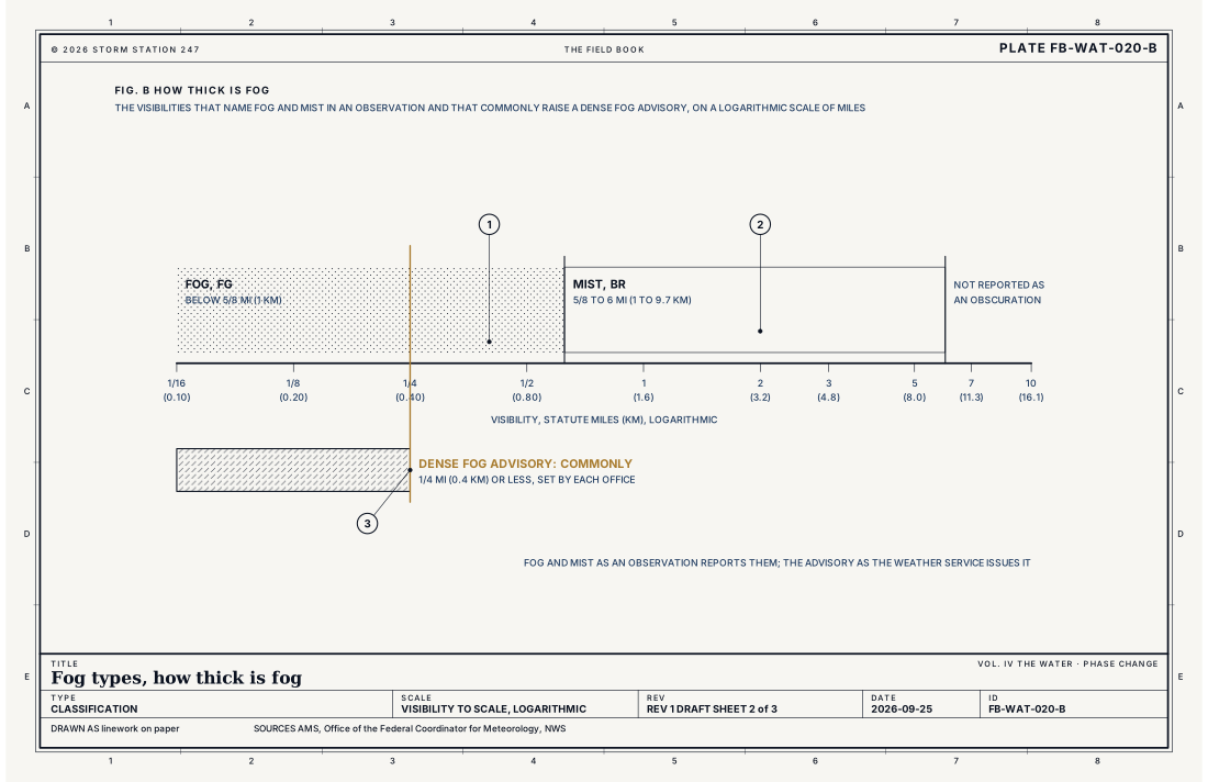
- Fog, below 5/8 mile
- Mist, 5/8 to 6 miles
- The Dense Fog Advisory, commonly 1/4 mile or less
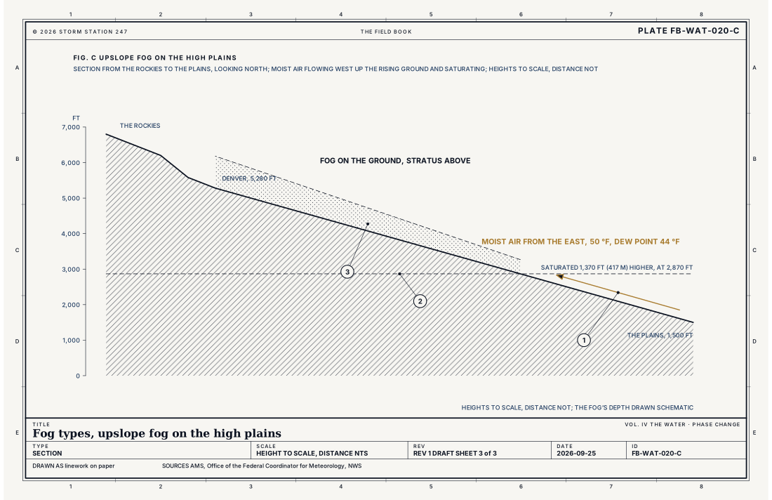
- Moist air flowing west, upslope
- The level where it saturates
- Fog on the ground, stratus above
Ingredients
- Moist air near the ground, its dew point close to its temperature
- A way to close the gap: cooling from below, cooling by rising, or water added by evaporation
- Light wind, enough to spread the fog but not to mix in drier air from above
Scales
- time
- from an hour at dawn to days in a cold valley or on a cold coast
- horizontal
- a single valley to hundreds of miles (hundreds of km) of coast or plain
- vertical
- from a few feet (1 m) to about 1,000 ft (300 m) deep
- orlanski
- meso
Equations
How far rising air climbs before it saturates
- the rise, ft
- the dew point spread at the start, °F
- the dry adiabatic rate, 5.4 °F per 1,000 ft (9.8 °C per km)
- the rate at which the rising air's dew point falls, about 1.0 °F per 1,000 ft (1.8 °C per km)
Assumes Air rising without mixing or condensing; the spread closes about 4.4 °F every 1,000 ft (8.0 °C per km).
Working form Air on the plains at 50 °F with a dew point of 44 °F, a spread of 6 °F, saturates after rising about 1,370 ft (417 m). The plains rise more than 3,000 ft (900 m) from central Kansas to Denver, so the air flowing west reaches saturation well before the mountains, and upslope fog and stratus fill the western plains.
Signatures
- sounding
- a surface inversion with the air saturated beneath it; the temperature and dew point lines together at the ground
- surface
- the visibility falling below 5/8 mile; the temperature and the dew point equal; light wind
- satellite
- a smooth; flat grey or white sheet in the valleys and along the coast at dawn; eroding from its edges as the sun climbs
- radar
The numbers
| Quantity | Value, and the kind of number it is |
|---|---|
| Fog | A visible aggregate of minute water droplets suspended in the atmosphere near the surface, reducing the visibility below 5/8 mile (1 km)Standard, Glossary of Meteorology |
| Fog in an observation | FG when the visibility is less than 5/8 statute mile; BR, mist, from 5/8 to 6 statute miles; FZFG, freezing fog, when the temperature is below freezingStandard, Federal Meteorological Handbook No. 1 |
| Dense Fog Advisory | Commonly for fog reducing the visibility to 1/4 mile (0.4 km) or less, set by each officeTypical, Directive 10-515 |
| Ice fog | Fog of ice crystals, usually at temperatures below about −22 °F (−30 °C)Standard, Glossary of Meteorology |
| Depth | Radiation fog commonly a few feet to several hundred feet (a few metres to about 100 m) deepTypical, Glossary of Meteorology |
How the station sees it
An airport station measures the visibility with a forward scatter sensor and reports FG below 5/8 mile, with the temperature and the dew point equal. Road stations measure it along the highways.
- Airport weather stations: the visibility, measured by a forward scatter sensor, and the temperature and the dew point
- Road weather stations: the visibility on the highways, where fog is most dangerous
How it is warned
A Dense Fog Advisory is issued for fog commonly thinning the visibility to 1/4 mile (0.4 km) or less, and a Freezing Fog Advisory when the drops freeze on roads. Drive slowly with low beams, and leave space.
| VTEC | Phenomenon | The alerts that carry it |
|---|---|---|
FG | dense fog | Dense Fog Advisory |
ZF | freezing fog | Freezing Fog Advisory |
MF | marine dense fog |
See also
- Phase changes of water FB-WAT-001
- Humidity variables FB-WAT-002
- Dew, frost and rime FB-WAT-021
- Water vapour as a gas FB-ENG-011
- Lapse rates and stability FB-ENG-005
- Stratus FB-SKY-017
- How to read a warning FB-STN-001
Sources
- American Meteorological Society. Glossary of Meteorology.
- Office of the Federal Coordinator for Meteorology. Federal Meteorological Handbook No. 1, Surface Weather Observations and Reports.
- National Weather Service. Directive 10-515, WFO Non-Precipitation Weather Products Specification.
Definition after the Glossary of Meteorology. Plate FB-WAT-020, revision 1, 2026-09-25. The number is permanent; cite it.