Station report
Cutler Farris Wharf, in 2 sheets Drawn from the register, in the manner of the Field Book, and opened beside the plates that explain each part of it.
1 The sun2 The instrumentOn Oct 11 the noon sun stands 38 degrees above the horizon at 44.66 N, and the day is 11 h 03 min long. Level ground there takes 62 per cent of the noon sunlight a surface facing the sun would.
Elevation of the noon sun at Cutler Farris Wharf, angles true: on Oct 11 it stands 38 degrees above the horizon, against 69 at the June solstice, 45 at the equinoxes and 22 at the December solstice; the day is 11 h 03 min long. 1 1 2 2 3 3 4 4 5 5 6 6 7 7 8 8 A A B B C C D D E E © 2026 STORM STATION 247 THE FIELD BOOK STATION REPORT NDBC-CFWM1 FIG. E THE SUN AT CUTLER FARRIS WHARF ELEVATION LOOKING WEST, SOUTH TO THE LEFT: THE NOON SUN ON THE DAY OF THE REPORT, AND AT THE SOLSTICES AND EQUINOXES; ANGLES TRUE THE STATION JUNE SOLSTICE 69° EQUINOXES 45° DECEMBER SOLSTICE 22° OCT 11, 38° SOUTH ANGLES TRUE; THE RAYS ARE OF ONE LENGTH AND DRAW DIRECTION ONLY DAY LENGTH 11 H 03 MIN LEVEL GROUND TAKES 62 PER CENT OF THE NOON SUN A FACING SURFACE WOULD LATITUDE 44.66 N; THE SUN'S DECLINATION -7.2° TITLE Cutler Farris Wharf, the sun STATION REPORT · DCP NDBC-CFWM1 TYPE ELEVATION SCALE ANGLES TRUE REV FROM THE REGISTER SHEET 1 of 2 DATE 2026-10-11 ID SR-NDBCCFWM1-1 DRAWN AS linework on paper SOURCES FB-ENG-007 A data collection platform. Its sensors, as its network builds them.
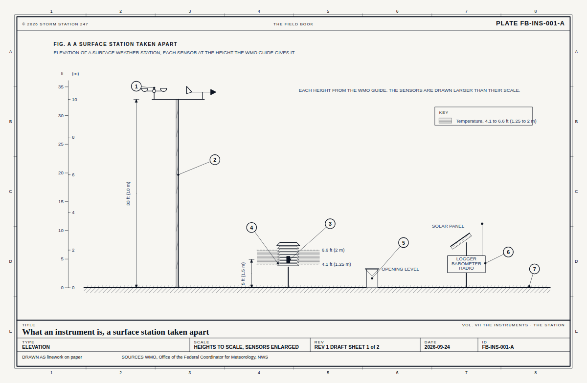
Elevation of a data collection platform, Cutler Farris Wharf, each sensor drawn and labelled with what it read: no reading in the last day. 1 1 2 2 3 3 4 4 5 5 6 6 7 7 8 8 A A B B C C D D E E © 2026 STORM STATION 247 THE FIELD BOOK STATION REPORT NDBC-CFWM1 FIG. F THE INSTRUMENT ELEVATION OF A DATA COLLECTION PLATFORM, EACH SENSOR WITH WHAT IT READ ANTENNA, SENDING BY SATELLITE - AIR TEMPERATURE - PRECIPITATION GAUGE - SCHEMATIC; THE SPACING BETWEEN SENSORS IS NOT TO SCALE TITLE Cutler Farris Wharf, the instrument STATION REPORT · DCP NDBC-CFWM1 TYPE ELEVATION SCALE SCHEMATIC REV FROM THE REGISTER SHEET 2 of 2 DATE 2026-10-11 ID SR-NDBCCFWM1-2 DRAWN AS linework on paper SOURCES FB-INS-001  FB-ENG-007, Fig. ARadiation budget